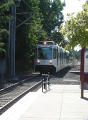
Aug 31, 2011
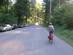
My friend Ed does a regular(ish) wednesday morning bike ride up one hill or another, and since this is the last week I can do it for a while (school starts next week, and I will be spending my early mornings babyherding) I decided I’d go out for one last fling.
The plan was to go up to Pittock Mansion, but when we got there the plan changed to going up to Council Crest. About halfway there I decided to escape because it was creeping up towards 9am and I wanted to get back home at a reasonable time, so I peeled off and (I thought) started heading towards town.
In Southwest Portland this is not a good plan, because that part of the city is a maze of twisty little passageways all alike. I ended up looping around one of the volcanic vents north of highway 26, then getting stuck in a maze of twisty little roads that deposited me right at the foot of the road up to the park. Okay, fine, I’ll go up there; but once I got up there I needed to get down, but I ended up going south on Council Crest Road, which deadended into a (steeply downhill with gravel) trail that dropped down off the summit and finally onto Fairmount Road, which, after passing by many houses in the so-expensive-we-couldn’t-afford-good-design style, finally deposited me onto a familiar road that dropped down into Portland proper.
I’d like to think that now that I’ve ridden these roads I’ll remember them and won’t get lost again, but hah! – this is Southwest Portland we’re talking about and that part of the city is a classic example of non-euclidian space.
—orc Wed Aug 31 12:50:42 2011
Aug 30, 2011
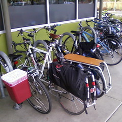
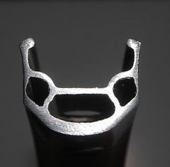
The Big Big Big Store was quite busy tonight, so when I arrived I had to lock the Trek up next to one of the other xtracycles that were parked up by Division St.
They may not look like it, but I believe that both frames are ~56cm. But my 56cm frame does not have a huge long stem or an electric motor attached to it, and the skateboard that came with my Free Radical kit has long-since been sent to a better home via ebay. (But I do like the pannier racks on that other xtracycle more than I like the water retaining saddlebags on mine.)
—orc Tue Aug 30 22:51:59 2011
Aug 28, 2011
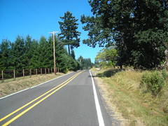
Last Tuesday, Ed Groth proposed a Saturday group ride out to Vernonia via the (ex-)CZ haul road and other logging roads, returning via the (ex-)United Traction line from Vernonia to Banks, then taking a collection of secondary roads back into Portland.
I thought it was a smashing idea, despite the “cross bike or 28mm+ tires recommended” note on the mail (not that I was going to pay any attention to this recommendation, because there’s no way I’m going to fit wide tires under MLCM’s fenders – I have a pair of el-cheapo wide Velo Orange fenders that I’m going to stuff under that bicycle sooner or later, but this is not the month for that – and furthermore I’d ridden the CZ haul road, plus the still-unpaved-at-that-time sections of the United Traction ROW on the same kind of Nashbar 26mm tires that are currently on the MLCM. So I set my alarm clock for 5:30, then woke up and staggered around like a clubbed ox for a hour before getting out the door, arriving at the designated departure point in North Portland at ~7:15.
It was all dark and silent. Uh oh. Maybe they left already?
I sat around for a few minutes trying to decide what to do, then bolted off towards Scappoose as fast as I could go in the hopes that I’d catch up with the group before they rolled into Scappoose. But despite sprinting up to Scappoose as fast as I could go (The Hood to Coast relay race had gone this way on Friday, and there was an amazing clutter of shattered blinky lights, earphones, and waterbottles along the side of the road, most of which I managed to resist stopping to pick up) I didn’t see anyone I knew, so I made what was probably a fatal mistake – I thought that maybe I was wrong and started before them, so I should park myself at the foot of the CZ haul road and wait for people to catch up to me.
Half an hour later, I reconsidered this decision, and thought that I should maybe return to Portland and make other plans. But I’d come this far, the Black Bear Coffee Company is always a good place to stop for a snack, and it would be much easier to piece together a 70 mile return (to round up to a R200) from there than it would be to make a 70 mile loop from Portland. So I hopped back on the MLCM and headed west on the CZ haul road.
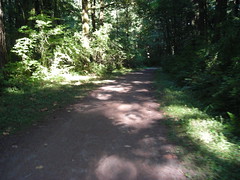
There’s more signage along the haul road these days, and it looks like Columbia County (or one of the trail-maintaining groups in the Scappoose area) have run a mower down the lower reaches of the road, but it’s not in any better condition than it was last year. But at least it’s been dry for a few weeks this year, so the steep ramps up to the summit aren’t quite as slippery as they were. And the second washout on the east side of the Nehalem divide (the 50+ foot climb down to a stream, then 50+ foot climb back up) is no longer there; someone dropped a culvert into the stream, then backfilled with coarse ballast so there’s a narrow and almost ridable lane across the top of the fill (the ballast is baby-head sized sharp rocks, which I’m sure would be ridable if I was more used to riding on that sort of surface, but I was just as happy to walk the 150 feet.)
From the summit of the road, it’s a nice drop down to Pittsburg – steeply at first, then leveling out and weaving along hillsides until it dumps you out just north of what used to be a log reload (and railroad yard?) decades ago. My plan was to follow the planned route and cut across to Vernonia on the Pebble Creek Mainline, but I completely missed where that branch cut out and didn’t realize it until the haul road crossed the Scappoose-Vernonia highway a mile or so this side of Pittsburg.
One annoying thing about the haul road on the west side of the Nehalem divide is that the parts that aren’t being actively used are grown up like mad – the grass, which is all dried this time of year, is knee high when you’re on a bicycle, and it’s apparently
not all grass either. The outside of my left lower leg ended up with a spectacularly red and painful rash that’s still there a day and a half later. Fortunately I wasn’t paying attention to it when I was actually out on the line, though!
When I reached Pittsburg, I switched over to highway 47 for the ~5 miles into Vernonia, where I stopped for a little something before returning to Portland. Vernonia was crawling with bicyclists that day, though – there was a local charity ride going on and a lot of people were riding into and out of Vernonia (on the ex-United Traction ROW) for the event. The Black Bear Coffee Company was crowded enough so I had to sit inside to eat my lunch, instead of my usual non-rainy routine of sitting out on the patio.
And when I was done, I rode down to the next rail line and hopped on the trail to return to the Portland area. This is a fairly scenic, but otherwise not mentionable section to ride on, and the only thing of interest I did with it this time around is to just stop pedaling when I crested the grade at Tophill and then just coast – for 6.7 miles – down to the bottom of the ramp just south of Pongratz Road (there’s a quarter-mile section past the road where the landowner graded the railroad embankment, so there’s a tiny upgrade just north of a bridge over a stream. That tiny upgrade killed the last of my momentum and I had to start pedalling from that point.)
And then into Banks and the end of this section of railroad trail. I stopped at the Banks terminus to refill water bottles and eat an orange, and while I was doing this I first got one of those scammer phone calls, and then when I was getting ready to leave some bozo in a sedan came driving down the main drag calling out to every bicyclist he passed to “GO BACK TO PORTLAND!” (with one pathetic “AND GET OFF MY ROADS!” shouted over his shoulder as he drove off into the distance.) The funny thing about this is I’d suspect that the vast majority of the riders this day were from Washington County, thanks to the charity ride, and there’s no back involved in them going to Portland unless they were doing it for one of the big Portland-based charity bikemobs.
But here I was in Banks with about 45 miles (and one climb over the West Hills) to go to round up to 200km. And I had no interest in dropping down into the Forest Grove/Hillsboro/Beaverton urban area, but instead thought that I could reverse some of the route of the Verboort Flat Tire Extravaganza!, then cut across on secondary roads to get to Old Cornelius Pass road.
I’d looked at maps and knew that it was possible to get from Jackson School Road to Jackson Quarry Road without dropping down to West Union – about halfway between West Union and the upper end of Jackson School the better paved part of the road turns off to the east (and becomes Mason Hill Road) and joins up with Jackson Quarry Road . Every time I’ve ridden up Jackson School Road, I’ve wondered where that other road goes (aside from the vague “connects to Jackson Quarry Road”) and this was the day to find out.
Mason Quarry Road mainly goes up through cultivated fields. There’s very little shade, and it’s quite hot, but it’s less than a mile before you reach the (unmarked; there used to be a road sign but all that’s left is the sign holder) junction with Jackson Quarry Road. And that goes down abruptly to Jackson Quarry, and then turns sharply right and winds gradually up to the heights above Helvetia (passing through a fairly tony suburban neighborhood with some huge ugly houses perched on the hillside south of the road) and then dropping down to the junction with Helvetia Road, which then goes steeply up to a little bit past the Helvetia church, and then steeply down through Helvetia and the junction with Phillips Road, which cuts over to Old Cornelius Pass Road.
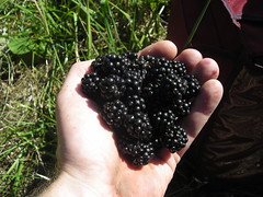
I skipped the Rock Creek Tavern this time around, but when I passed a large blackberry bramble groaning under the weight of ripe blackberries, I paused for long enough to eat a pint and a half of berries before continuing up to the head of Old Cornelius Pass Road and onward to Skyline. Skyline Road has, as is traditional, a large number of extremely fit riders on light bicycles cruising back and forth, so I was a slowly moving obstacle course all the way down to Saltzman Road, where I gtfo'ed Skyline for a nice gravelly descent down what used to be a logging plank road to highway 30 and the last 15 miles to home.
To call Saltzman Road “gravel” is perhaps giving the wrong impression. It is (mainly) gravel – from looking at the surface I think it was macadamed once upon a time, but that was many years ago and most of the tar has disintegrated – but inside Forest Park it’s very well maintained and doesn’t have the sort of spectacular potholing that the two City of Portland sections on each end have. So you can just release the brakes and slither all the way down without worrying that a GIANT POTHOLE will leap up and eat your bicycle. I didn’t completely release my brakes, though – there are a good number of hairpins and I didn’t want to see if I could skid over the edge of the cliff-face :-)
And at the bottom, of course, you’re back in the city. So highway 30 to St Helens, St Helens to Vaughn/Thurman, Vaughn/Thurman to Naito, and Naito to the Hawthorne Bridge, after which I jumped onto the Springwater Trail (Portland Traction) for the ride down to my house.
At the foot of the Springwater Trail (Spokane Street) I realized two things; first, I was almost exactly six miles short of 200k, and secondly I was ravenously hungry and if I stopped at home to get something to eat before wrapping up to 200km I would never get out of the house again that night. So instead of taking Spokane Street home, I took the gravel part of the Springwater Trail down to Garthwick, circumnavigated Garthwick, then detoured through the Milwaukie industrial park before jumping back onto the Springwater Trail to ride out to 45th, where I turned back and rode city streets back to Tacoma, then 17th/19th back to home, finishing up with 200.5 kilometers and my second R200-length loop of the month (in about 10h30; not nearly as slow as the bridge of the gods preride, but still pretty slow.)
At least I can consider the 27 miles of gravel as a good excuse for being slothful!
I never did manage to catch up to Ed and company, but there are many pictures to make up for that.
—orc Sun Aug 28 23:53:28 2011
Aug 26, 2011
Aug 25, 2011
I finally got around to throwing out the mlcm’s old rear rim tonight. But to fit it into the trashcan, I needed to saw it in half, and when I had it sawn in half I had to take a picture to show how badly a wheel can get worn after a years worth of riding long loops in the rain and grit.
If you look really closely, you might be able to see the faint remains of the left hand wear notch. If you’re dreaming, you might be able to see the right hand wear notch.
—orc Thu Aug 25 21:47:27 2011
Aug 24, 2011
I think I prefer the paint :-)
—orc Wed Aug 24 20:32:48 2011
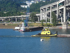
Now that Tri-Met is actually working on building the trolley line down to Milwaukie (you can take my spluttering complaints about the $130 million/mile cost as read; the layers and layers of graft that surround public works in this country are pretty shameless, and it doesn’t help to know that this is an order of magnitude less than what’s being proposed to the replacement I-5 Columbia River bridge) there’s suddenly a whole bundle of maritime traffic between the Marquam & Ross Island bridges. There are tugboats galore, and if you’re down there with a camera at the right time of the day you can see traffic that looks dimly like Portland’s glory days.
—orc Wed Aug 24 11:24:36 2011
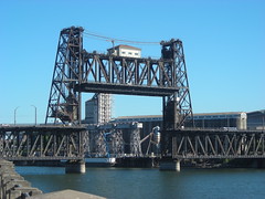
The Steel Bridge at about 9am this morning, not quite late enough to avoid delaying late commuters.
—orc Wed Aug 24 11:16:52 2011
Aug 23, 2011
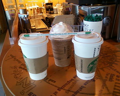
… at the St*rb*cks in the Milwaukie Marketplace mall.
—orc Tue Aug 23 01:47:30 2011
Aug 22, 2011
On Saturday, Ed Groth, Theo Roffe, yours truly (aka “The Portland Crew”),
and Ed’s sweetie Steph went out and did the traditional preride for the
Bridge of the Gods 200k to verify that there weren’t going to be any
horrible surprises on the day of the ride.
There are some surprises, but none of them are horrible, and, aside from
the teeny detail that it was in the high 90°F’s on the way back in
from Stabler it was a very pleasant and leisurely loop.
Our plan was to start at 7am, but Ed had a flat on the way to
Wilshire Park and discovered that his rear tire had worn down
to the casing, and by the time he bolted home (he liberated Steph’s
bicycle for the sprint across town for another Col de la Vie), got
the new tire, returned, and reassembled his bike with non-leaking
wheels it was 7:30, so we had to start then.
The wind was gently blowing from the east, but getting out of town
was still really easy; we scuttled down 33rd towards the Columbia
at a fairly high speed (33rd, with the noticable exception
of a fairly narrow bridge across Killingsworth and the OR&N
mainline, is nice and wide and untrafficked early in the
morning), turned east onto the Marine Drive bikepath, and
dodged the wind at high speed all the way into Troutdale.
Troutdale has a lot of services, so if you’re feeling a bit
peckish it’s easy to drop into a convenience store and pick
up a little something. Note that there is also some road
construction along the frontage road that leads into downtown
Troutdale, but at least on Saturday it was all on the north
side of the road so there shouldn’t be anything to worry about
aside from stray gravel.
We didn’t stop at Troutdale, but continued onto the Historic
Columbia River Highway, which we would more-or-less stay on
all the way out to Cascade Locks. But first we had to climb
the hill up to Crown Point, which is steep, but not horrifyingly
so, and rewards you for the climb by wonderful views at the Vista
House control, and then a lovely twisty descent back down into
the gorge before resuming our flight east.
Unfortunately, we paused to regroup, and then to chat, at Crown
Point and before we knew it half an hour had vanished away. And
when we reached Multnomah Falls, we paused for a little something
which then became a little something and a long chat with some
other cyclists who were doing a short 100 mile loop, and before
we knew it about 40 minutes had vanished away.
Ugh.
But, after the
obligatory railroad photo,
we got onto our bicycles and continued east.
The drivable part of the Historic Columbia River Highway ends not too far
east of Multnomah Falls (8 miles, maybe?) and if you want to go further
east you’ve got to take the freeway. The freeway is not actually that
bad; there used to be two narrow bridges that forced bicycles out into
the traffic lanes, but now there’s just one that’s just past where the
frontage road (the Columbia River Highway crosses under the freeway
at Ainsworth Park, and then peters out to a dead-end path soon thereafter)
dumps you onto I84, and once you’ve squoze past the bridge and dodged
the g-dd-mn-d rumble strip that starts up just past it, you’re on
a nice wide shoulder for the 2.4 miles to the Bonneville dam exit.
Theo and I were running ahead of the others here, but when we hit the
highway he accelerated up to about 25mph, and I couldn’t keep up for
more than a mile of this.
At Bonneville, we jumped off the highway and switched back to the
Historic Columbia River Highway (it’s actually a bikepath now, which
meanders on and off along the old ROW) but first paused to pick blackberries
(and very good they are, blackberries!), regroup, fix a flat (Ed picked up
a staple in his new tire along the freeway), and gossip with the cyclists
we chatted with back at Multnomah Falls.
The bikepath/Columbia River Highway is very nice along here; it’s
slowly falling to ruin, but it’s still ridable if you’re cautious
(treeroots are snaking under the pavement, so there are stretches
that are corregated like you wouldn’t believe) and pay attention
to the traffic signs.
And then the Columbia River Highway swings out around a spur of
the mountain, swings back south, and curves around to a STOP sign,
followed immediately by a flight of stairs down to a side-of-the-freeway
path (I’m guessing that the highway crossed over the I84 ROW here,
but was simply removed when the freeway was cut in.) There was actually
a traffic jam here, because there was a family (with a kid trailer!)
going slowly down the stairs, and another couple of cyclists coming up
the stairs. I tried to take advantage of the nice bicycle wheel
channels alongside the stairs, but had to give up and shoulder the MLCM
halfway down the stairs.
And then, after a few more twists and turns, we were in Cascade Locks,
where we were about to sit down for a nice leisurely lunch when someone
(Theo?) looked at the cuesheet and realized that we only had about 1h30
before the Stabler Market control (15 miles and about 1000 feet away,
and our brevet average speed was just about 9.5mph when we realized this)
closed. So we changed plans and got some drinks instead, wolfed them
down, and bolted for the Bridge of the Gods so we could get down to the
Washington Side of the loop.
After crossing over the Columbia, Steph decided that she’d rather just
park herself at the tiny little scenic viewpoint there and read than do
the run up to Stabler Market. A wise choice, because in the interval
between leaving Marine Drive back in Troutdale and getting back to
the river near Stevenson the wind had picked up substantially and, to
add insult to injury, the temperature had gone up to the mid 90°Fs.
So Steph sat down to read, and Ed, Theo, and I bolted east as quickly
as the headwind would let us. A couple of things we discovered about
the run up to Stabler are that
- the roads are generously wide enough
so that you don’t feel squashed by the
- infrequent traffic (the roads
are generously wide enough, but the shoulders are all rough gravel.
You want to stay on the road) and
- they don’t call it Wind River Road
for nothing – as we climbed away from the river first we got stiff headwinds
on the leg into Carson, and then stiff tailwinds as the grades steepened on
the climb up to Stabler.
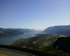
About halfway up Wind River Road you pass over the aptly named High Bridge;
the views, at least the views I saw from very short peeks, are spectacular,
as well they should be because it’s 300 feet down to the Wind River. If you
haven’t burned away two hours gossiping on the way up, you should have enough
time to stop and take a picture or two. We’d burned away two hours gossiping,
so we didn’t stop but continued directly towards Stabler with visions of a little something dancing in our heads (at least in my head; I was thinking how nice it would be to have a nice cold sodapop before we came back down the mountain.)
And then we reached Stabler and had the second (and more unpleasant) surprise
when we discovered that the Stabler Market was no longer in business,
and had not been in business for at least 2 years. Whoops, no sodapop
here, and no anything (the people who lived where the store used to be
were very nice and let us refill our water bottles, but would not want
to be used as a resupply dump on a regular basis) – if you’re running
short of food and or water (or if your water has started boiling from
the heat) by the time you reach Carson, for the love
of G-d STOP! and resupply there – there are 4-5 places along the
road before you pass the Georgia-Pacific sawmill, and then nothing
for the 6 miles and change up to the New! Hemlock Y Road info control.
So the three of us scrambled around for a while collecting a pile of
info control questions, then got back onto our bicycles and bolted back
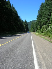
down the road to SR14, regrouping with Steph, and points west.
SR14 isn’t nearly as nice as the Historic Columbia River Highway, but
when the wind is at your back it’s nice and fast up to
Beacon Rock,
where the road pitches steeply upward to cross over the debris apron
north of the lava plug.
When you’re winding up that pitch, you may kick yourself that you
didn’t pause at the gas station/convenience store at North Bonneville,
but at the top of the ramp there’s a parking lot and a nice log-built
bathroom facility with potable running water. If your water bottles
are piping hot, this is a wonderful chance to put cooler water in
them, because it’s not too far down the road before a much longer
climb awaits.
Ed was overheating at Beacon Rock, so we stopped there for a
considerable amount of time to cool down, and then hopped onto our
bicycles and headed west again.
By this time I was feeling a need for something other than a little
something (we didn’t get anything at Stabler Market, of course, and
were worried enough about our timings so that we didn’t stop in Carson,
Stevenson, OR North Bonneville) and had demolished most of the science
diet in my rando bag and was down to trying some of the “5 hour energy”
drinks I was saving for an emergency (summary: 30 minute energy, perhaps,
and G-d are they nasty!) So Ed, Steph, and Theo vanished to the west and
I plodded along at the back past the Skamania store (I should have stopped,
but was thinking more of catching up to everyone else) and then, slowly,
up the long and depressingly hot ramp up Cape Horn.
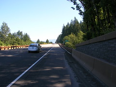
When you reach Krogstad Road (it’s not obvious, but it is signed and
when we went through the fellow who lives in the house by the junction
was selling crystals just east of the lane), you might think that
the climbing is all done for the day. Do not believe your lies.
Krogstad road goes UP precipitously (widening into a two-lane road after
a quarter mile or so) and then you go up that distance again on Canyon Creek
Road before it summits and drops you down (a steep descent on a
wide road with gentle curves) to the Washougal River Mercantile,
where you can finally get that little something along with a receipt
and/or signature for your brevet card.
The third surprise is Washougal Road. It’s been recently chipsealed,
which is not the grandest thing in the world, but that’s not the
surprise. The surprise is that, at least on our ride, it had been
a long hot day and many many people had been down on the river and
were starting to pack up and drive home. And some of them were
toasted, and when they were surprised by bicyclists on Their! Road!
reacted as rudely as they could without risking arrest for assault
and battery.
Drunken insults (“get a car!”) screamed out car windows? Check.
Honking just as the truck (lots of SUVs on on this road) passed?
Check. Brushing by 3 inches away from my elbow? Oh, yes, check
that a dozen times or so.
By the time we reached the foot of this road I was well and ready
to get the eff out of Washington, but fortunately the rest of the
way out of the state is along less trafficked routes (6th Ave,
which becomes the old Evergreen Highway, is Slab Creek Road
levels of roughness, but had almost no traffic aside from lunatic
bicyclists) and we were able to make it over to the I205 bridge
and across the river with no problems.
And then we were in Portland, and it was just a matter of winding
along the south side of the airport to get to 37th, then climbing
up to Wilshire Park where we staggered in at the crack of dusk,
finishing the loop in a luxurious 12h27.
If I was going to do this ride again (can’t do it on the third,
because someone needs to either hand out brevet cards in the morning
or pick them up in the afternoon!) I’d make a few changes in how I
do it.
- First, I’d be a lot faster at the controls and scenic viewpoints
between Troutdale and Cascade Locks. Burning off 1h40 before
reaching Cascade Locks is silly enough, but then burning off
an additional 20 minutes before getting onto the Bridge of the Gods
added insult to injury.
- Second, I need to take advantage of the services in Carson,
Stevenson, or North Bonneville, because the climb up Cape Horn
is extremely unpleasant when it’s hot, sunny, and the water in
my water bottles is piping hot.
- Third, less science diet, more real food. I took a couple
of bananas along, and they were nicer than any of the science
diet was, but they didn’t last past Cascade Locks (and in any
case they aren’t as good as potatoes and/or fruitcake.)
- Fourth, maybe this would be a nicer brevet if it’s a cloudier
day?
(It’s not actually nasty and brutish, but it was hot, and that made the climbs up to Beacon Rock and Cape Horn a lot nastier than they would normally be. If the highs aren’t in the 90°Fs, the climb up Cape Horn would merely be annoying.)
The gory details, in bullet point form
- 127 miles, maybe (the cuesheet claims 125 miles, but both Theo and my odometers were registering a mile ahead of the cuesheet before more than 20 miles had gone by)
- in 12h27, of which
- 8h58 was spent riding, and the largest chunk of the residue was spent gossiping.
- And I took a few pictures, as is traditional.
—orc Mon Aug 22 01:01:39 2011
Aug 20, 2011
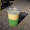
Take a Slushee, drink about half
of it, then fill the glass with Gatorade. Salts, sugars,
cold, and fluids – just the thing after climbing Cape
Horn on a 95°F day.
—orc Sat Aug 20 23:27:06 2011
Aug 19, 2011
Who needs a Holga or one of those fancy iPhone apps when you can get this sort of old-timey photographic washed-out colo(u)r with a 49¢ el-cheapo photo sensor?
The tiltedness of the photo just adds to the retro look.
—orc Fri Aug 19 14:13:23 2011
Aug 18, 2011
Testing the built-in camera in a “new” cellphone (actually an old one; my mother replaced it with a Linux box) by taking pictures of the bears.
—orc Thu Aug 18 23:47:50 2011
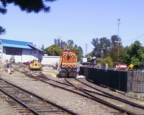
Two pusher Eng!s shove a container freight towards what used to be Brooklyn Yard.
—orc Thu Aug 18 00:11:57 2011
Aug 17, 2011
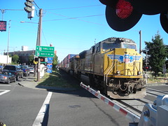
A northbound Coast Starlight crosses 11th/12th/Division just moments after we cleared the crossing.
—orc Wed Aug 17 23:57:51 2011
Aug 16, 2011
I had a job interview out in Hillsboro today, and I decided that instead of riding my bicycle there and back (which would have meant that I would have arrived as a ball of sweat) I would get a ride out from the best and then just take the interurban back into town.
It’s certainly a good choice if you’re trying to get work done during your commute, because it took me 2h15 to go the ~20 miles from the Hillsboro Airport back to my door.
I’m not so sure about it being a good choice if I want to remain sane. At least if I was offered this job (which I’d have to take, of course, because my unemployment goes *poof* when it even smells something like a job offer. It’s a bonus that the descriptions I was given of the job make it sound quite interesting!) I could get my bike riding in by riding out there in the morning and riding back in the evening and only taking 3 hours and change instead of 4 hours and change.
My cow orkers would just have to get used to my wearing +4s to work all the time.
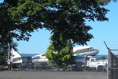
—orc Tue Aug 16 23:43:58 2011
A
museum’s C-47 basks in the sun at Hillsboro Airport this afternoon.
—orc Tue Aug 16 22:48:15 2011
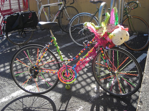
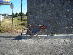
A summer bike at Trader Joe’s
—orc Tue Aug 16 10:56:42 2011
Aug 15, 2011
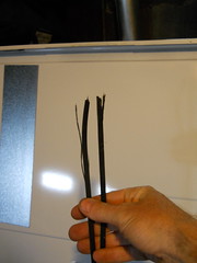
I disassembled the broken dryer today, and found the drive belt coiled up on the floor of the thing. Obviously something had been binding and the belt finally went *snap* in protest.
—orc Mon Aug 15 20:14:56 2011
Aug 14, 2011
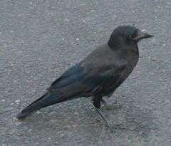
An inquisitive crow up at the Seven Corners New Seasons; it walked up close enough when taking a look at my camera so that the built-in flash actually had an effect on the photo.
—orc Sun Aug 14 23:37:30 2011
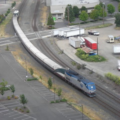
A southbound Cascades approaches Union Station, as seen from the top of the (temporarily car-free) Fremont Bridge this morning.
—orc Sun Aug 14 15:41:40 2011
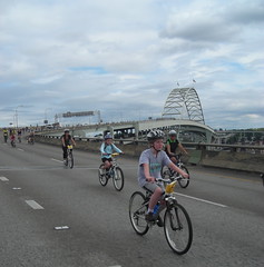
Russell descends from the Fremont Bridge at the end of this year’s Providence Bridge Pedal®©™.
—orc Sun Aug 14 15:35:50 2011
Aug 12, 2011
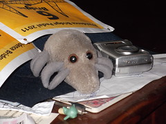
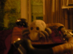
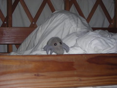
A stealthy no-flash photo of the rare and elusive giant plush
Dust Mite—orc Fri Aug 12 23:31:42 2011
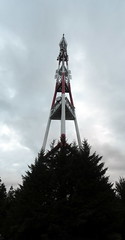
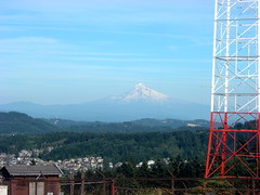
Mount Hood from the summit of a somewhat smaller volcano.
—orc Fri Aug 12 23:29:18 2011
Aug 11, 2011
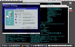
Civilization II doesn’t run on MacOS X, or inside Wine (or at least the commercial version of Wine that is all that’s available for MacOS – at least the vendor provides evaluation copies so I didn’t end up spending money before making that discovery) so I needed to grab a virtual machine monitor (SunOracle’s VirtualBox, which has horrible documentation and a spectacularly stereotypically snobbish Open Source®©™ support community) and install a full version of Windows 95 (sans networking!) so I could load up Civ and conquer the world again.
I always knew there was a reason that I didn’t throw out my copies of Windows 95 (or the installation manuals that come with the very important license keys!)
—orc Thu Aug 11 23:29:43 2011
Aug 10, 2011
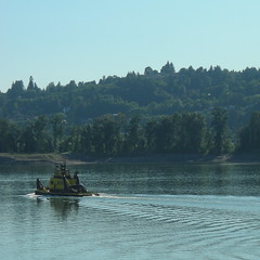
The RossIsle, captured en passant (and into the sun) when I was on my way back home from the Big Big Store.
—orc Wed Aug 10 23:53:44 2011
Aug 08, 2011
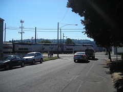
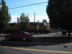
Along Division Street at about 4:30pm today.
—orc Mon Aug 8 23:03:34 2011
Aug 07, 2011
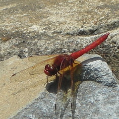
It’s not as good as a photo from my *istDS (there are some advantages to larger pieces of film and/or imaging sensors, and there are even better advantages from using the nice glass that you can find in old manual focus lenses) but given enough light even an el-cheapo point-and-shoot can capture a pretty good picture of an insect if it bothers to stay in one place long enough.
—orc Sun Aug 7 23:53:41 2011
Aug 06, 2011
We’d gone out for the day to visit with my brother, who’s in town after a job interview in Seattle (the economy might be bad for minions, but it’s still pretty good for senior executives) and when we came back I went down the basement to empty the dryer and refill it with some of my more durable woolens.
Hmmm. The clothes in the dryer are still wet. So let’s set the timer back, press the switch and … whirrrrrrrrrrrr the drum didn’t start spinning.
While I panicked, the best looked through our “how to fix random household appliances” book and found a section that seemed to strongly imply that the belt drive broke. Okay, so now all I need to do is take the whole dryer apart to see if there are fractional belt pieces lying inside the box.
At least it’s summer and if it’s not the belt but some sort of dryer-killing disease I can string up clotheslines outside to take advantage of the month and a half before the fall rains come in.
—orc Sat Aug 6 22:48:40 2011
Aug 05, 2011
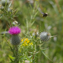
A bumblebee flies away from a thistle after collecting a load of nectar for the grubs back home.
—orc Fri Aug 5 22:57:54 2011
Dust Mite chills in the yurt at Cape Lookout.
—orc Fri Aug 5 22:49:17 2011
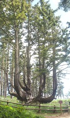
The octopus tree at Cape Mears – it’s only about half a mile off the Three Capes Scenic Loop, but that’s 10 minutes by bike so I never see it when I’m riding a loop out there by myself. Fortunately I wasn’t on a deadline today when coming back from camping with my family.
—orc Fri Aug 5 20:51:28 2011
Aug 04, 2011
Aug 02, 2011
A couple of months ago, I replaced the crankset on the mclm with a somewhat more modern unit with external bearings and everything. Today, after two months of increasingly unhappy knees and
legs after reasonably long loops (the Codename:UGB210 loop last Saturday was instructive, but not in the way I wanted,) I finally snapped, took the new crankset off and put the old one back on.
The Sram Apex crankset I’d installed had 172.5mm crankarms, and a tread of ~150mm. The old crankset has 170mm crankarms and (on a 113mm bottom bracket) a ~140mm tread. It doesn’t seem like very much, but the final straw today was when I came back from the store (after one short loop on the mlcm and another on the trek,) sat down, then listened to my knees going “pop!” “ping!” and “klunk” every time I moved my legs. I’m fond of my legs, and I managed to ride – with the old crankset – a collection of loops up to 600km this year without any knee or leg discomfort at all.
So I ripped the Sram crankset out, threw it away (not really; I’m going to try and sell it, but it’s not usable for me), took the old mlcm crankset off the trek and moved it back to the mlcm (with a brief intermission to swap chainrings,) dug out one of my old Biopaced cranksets and the loose-bearing bottom bracket that used to be on the trek, put them onto the trek, tried to tighten up all the nuts and bolts, and collapsed into a heap.
I’ve discovered that the spiffy Sram hex-socket-on-both-sides chainring bolts have one fatal weakness to them, in that it’s really easy to destroy them, even if I tighten them with short wrenches. When I swapped the alpine double chainrings over to the Sram crankset, I thought I was carefully tightening the bolts to spec, but apparently my torque wrench is measuring low because I ripped one of the bolts in half when bringing it up to spec. And then I ripped another one in half when I was paranoiacally tightening it with a very short wrench :-(
I hope that putting back the old crankset(s) (and I’m going to have to retune my saddle and handlebar position, but I need to do that anyway because my parents gave me some money as a birthday present and I used a bit of that to get some Salsa cowbell handlebars which are going to play merry hell with the front end configuration of the mlcm) makes my legs happier when I go out for my next reasonably long loop.
—orc Tue Aug 2 23:28:38 2011
—30—