Nasty, Brutish, and Hot – Bridge of the Gods 200k preride report
On Saturday, Ed Groth, Theo Roffe, yours truly (aka “The Portland Crew”), and Ed’s sweetie Steph went out and did the traditional preride for the Bridge of the Gods 200k to verify that there weren’t going to be any horrible surprises on the day of the ride.
There are some surprises, but none of them are horrible, and, aside from the teeny detail that it was in the high 90°F’s on the way back in from Stabler it was a very pleasant and leisurely loop.
Our plan was to start at 7am, but Ed had a flat on the way to Wilshire Park and discovered that his rear tire had worn down to the casing, and by the time he bolted home (he liberated Steph’s bicycle for the sprint across town for another Col de la Vie), got the new tire, returned, and reassembled his bike with non-leaking wheels it was 7:30, so we had to start then.
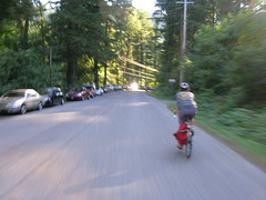
The wind was gently blowing from the east, but getting out of town was still really easy; we scuttled down 33rd towards the Columbia at a fairly high speed (33rd, with the noticable exception of a fairly narrow bridge across Killingsworth and the OR&N mainline, is nice and wide and untrafficked early in the morning), turned east onto the Marine Drive bikepath, and dodged the wind at high speed all the way into Troutdale.
Troutdale has a lot of services, so if you’re feeling a bit peckish it’s easy to drop into a convenience store and pick up a little something. Note that there is also some road construction along the frontage road that leads into downtown Troutdale, but at least on Saturday it was all on the north side of the road so there shouldn’t be anything to worry about aside from stray gravel.
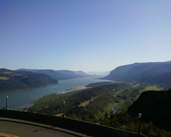
We didn’t stop at Troutdale, but continued onto the Historic Columbia River Highway, which we would more-or-less stay on all the way out to Cascade Locks. But first we had to climb the hill up to Crown Point, which is steep, but not horrifyingly so, and rewards you for the climb by wonderful views at the Vista House control, and then a lovely twisty descent back down into the gorge before resuming our flight east.
Unfortunately, we paused to regroup, and then to chat, at Crown Point and before we knew it half an hour had vanished away. And when we reached Multnomah Falls, we paused for a little something which then became a little something and a long chat with some other cyclists who were doing a short 100 mile loop, and before we knew it about 40 minutes had vanished away.
Ugh.
But, after the obligatory railroad photo, we got onto our bicycles and continued east.
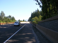
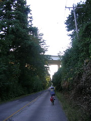
The drivable part of the Historic Columbia River Highway ends not too far east of Multnomah Falls (8 miles, maybe?) and if you want to go further east you’ve got to take the freeway. The freeway is not actually that bad; there used to be two narrow bridges that forced bicycles out into the traffic lanes, but now there’s just one that’s just past where the frontage road (the Columbia River Highway crosses under the freeway at Ainsworth Park, and then peters out to a dead-end path soon thereafter) dumps you onto I84, and once you’ve squoze past the bridge and dodged the g-dd-mn-d rumble strip that starts up just past it, you’re on a nice wide shoulder for the 2.4 miles to the Bonneville dam exit.
Theo and I were running ahead of the others here, but when we hit the highway he accelerated up to about 25mph, and I couldn’t keep up for more than a mile of this.
At Bonneville, we jumped off the highway and switched back to the Historic Columbia River Highway (it’s actually a bikepath now, which meanders on and off along the old ROW) but first paused to pick blackberries (and very good they are, blackberries!), regroup, fix a flat (Ed picked up a staple in his new tire along the freeway), and gossip with the cyclists we chatted with back at Multnomah Falls.
The bikepath/Columbia River Highway is very nice along here; it’s slowly falling to ruin, but it’s still ridable if you’re cautious (treeroots are snaking under the pavement, so there are stretches that are corregated like you wouldn’t believe) and pay attention to the traffic signs.
And then the Columbia River Highway swings out around a spur of the mountain, swings back south, and curves around to a STOP sign, followed immediately by a flight of stairs down to a side-of-the-freeway path (I’m guessing that the highway crossed over the I84 ROW here, but was simply removed when the freeway was cut in.) There was actually a traffic jam here, because there was a family (with a kid trailer!) going slowly down the stairs, and another couple of cyclists coming up the stairs. I tried to take advantage of the nice bicycle wheel channels alongside the stairs, but had to give up and shoulder the MLCM halfway down the stairs.
And then, after a few more twists and turns, we were in Cascade Locks, where we were about to sit down for a nice leisurely lunch when someone (Theo?) looked at the cuesheet and realized that we only had about 1h30 before the Stabler Market control (15 miles and about 1000 feet away, and our brevet average speed was just about 9.5mph when we realized this) closed. So we changed plans and got some drinks instead, wolfed them down, and bolted for the Bridge of the Gods so we could get down to the Washington Side of the loop.
After crossing over the Columbia, Steph decided that she’d rather just park herself at the tiny little scenic viewpoint there and read than do the run up to Stabler Market. A wise choice, because in the interval between leaving Marine Drive back in Troutdale and getting back to the river near Stevenson the wind had picked up substantially and, to add insult to injury, the temperature had gone up to the mid 90°Fs.
So Steph sat down to read, and Ed, Theo, and I bolted east as quickly as the headwind would let us. A couple of things we discovered about the run up to Stabler are that
- the roads are generously wide enough so that you don’t feel squashed by the
- infrequent traffic (the roads are generously wide enough, but the shoulders are all rough gravel. You want to stay on the road) and
- they don’t call it Wind River Road for nothing – as we climbed away from the river first we got stiff headwinds on the leg into Carson, and then stiff tailwinds as the grades steepened on the climb up to Stabler.
About halfway up Wind River Road you pass over the aptly named High Bridge; the views, at least the views I saw from very short peeks, are spectacular, as well they should be because it’s 300 feet down to the Wind River. If you haven’t burned away two hours gossiping on the way up, you should have enough time to stop and take a picture or two. We’d burned away two hours gossiping, so we didn’t stop but continued directly towards Stabler with visions of a little something dancing in our heads (at least in my head; I was thinking how nice it would be to have a nice cold sodapop before we came back down the mountain.)
And then we reached Stabler and had the second (and more unpleasant) surprise when we discovered that the Stabler Market was no longer in business, and had not been in business for at least 2 years. Whoops, no sodapop here, and no anything (the people who lived where the store used to be were very nice and let us refill our water bottles, but would not want to be used as a resupply dump on a regular basis) – if you’re running short of food and or water (or if your water has started boiling from the heat) by the time you reach Carson, for the love of G-d STOP! and resupply there – there are 4-5 places along the road before you pass the Georgia-Pacific sawmill, and then nothing for the 6 miles and change up to the New! Hemlock Y Road info control.
So the three of us scrambled around for a while collecting a pile of info control questions, then got back onto our bicycles and bolted back down the road to SR14, regrouping with Steph, and points west.
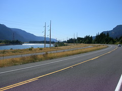
SR14 isn’t nearly as nice as the Historic Columbia River Highway, but when the wind is at your back it’s nice and fast up to Beacon Rock, where the road pitches steeply upward to cross over the debris apron north of the lava plug.
When you’re winding up that pitch, you may kick yourself that you didn’t pause at the gas station/convenience store at North Bonneville, but at the top of the ramp there’s a parking lot and a nice log-built bathroom facility with potable running water. If your water bottles are piping hot, this is a wonderful chance to put cooler water in them, because it’s not too far down the road before a much longer climb awaits.
Ed was overheating at Beacon Rock, so we stopped there for a considerable amount of time to cool down, and then hopped onto our bicycles and headed west again.
By this time I was feeling a need for something other than a little something (we didn’t get anything at Stabler Market, of course, and were worried enough about our timings so that we didn’t stop in Carson, Stevenson, OR North Bonneville) and had demolished most of the science diet in my rando bag and was down to trying some of the “5 hour energy” drinks I was saving for an emergency (summary: 30 minute energy, perhaps, and G-d are they nasty!) So Ed, Steph, and Theo vanished to the west and I plodded along at the back past the Skamania store (I should have stopped, but was thinking more of catching up to everyone else) and then, slowly, up the long and depressingly hot ramp up Cape Horn.
When you reach Krogstad Road (it’s not obvious, but it is signed and when we went through the fellow who lives in the house by the junction was selling crystals just east of the lane), you might think that the climbing is all done for the day. Do not believe your lies. Krogstad road goes UP precipitously (widening into a two-lane road after a quarter mile or so) and then you go up that distance again on Canyon Creek Road before it summits and drops you down (a steep descent on a wide road with gentle curves) to the Washougal River Mercantile, where you can finally get that little something along with a receipt and/or signature for your brevet card.
The third surprise is Washougal Road. It’s been recently chipsealed, which is not the grandest thing in the world, but that’s not the surprise. The surprise is that, at least on our ride, it had been a long hot day and many many people had been down on the river and were starting to pack up and drive home. And some of them were toasted, and when they were surprised by bicyclists on Their! Road! reacted as rudely as they could without risking arrest for assault and battery.
Drunken insults (“get a car!”) screamed out car windows? Check. Honking just as the truck (lots of SUVs on on this road) passed? Check. Brushing by 3 inches away from my elbow? Oh, yes, check that a dozen times or so.
By the time we reached the foot of this road I was well and ready to get the eff out of Washington, but fortunately the rest of the way out of the state is along less trafficked routes (6th Ave, which becomes the old Evergreen Highway, is Slab Creek Road levels of roughness, but had almost no traffic aside from lunatic bicyclists) and we were able to make it over to the I205 bridge and across the river with no problems.
And then we were in Portland, and it was just a matter of winding along the south side of the airport to get to 37th, then climbing up to Wilshire Park where we staggered in at the crack of dusk, finishing the loop in a luxurious 12h27.
If I was going to do this ride again (can’t do it on the third, because someone needs to either hand out brevet cards in the morning or pick them up in the afternoon!) I’d make a few changes in how I do it.
- First, I’d be a lot faster at the controls and scenic viewpoints between Troutdale and Cascade Locks. Burning off 1h40 before reaching Cascade Locks is silly enough, but then burning off an additional 20 minutes before getting onto the Bridge of the Gods added insult to injury.
- Second, I need to take advantage of the services in Carson, Stevenson, or North Bonneville, because the climb up Cape Horn is extremely unpleasant when it’s hot, sunny, and the water in my water bottles is piping hot.
- Third, less science diet, more real food. I took a couple of bananas along, and they were nicer than any of the science diet was, but they didn’t last past Cascade Locks (and in any case they aren’t as good as potatoes and/or fruitcake.)
- Fourth, maybe this would be a nicer brevet if it’s a cloudier day?
(It’s not actually nasty and brutish, but it was hot, and that made the climbs up to Beacon Rock and Cape Horn a lot nastier than they would normally be. If the highs aren’t in the 90°Fs, the climb up Cape Horn would merely be annoying.)
The gory details, in bullet point form
- 127 miles, maybe (the cuesheet claims 125 miles, but both Theo and my odometers were registering a mile ahead of the cuesheet before more than 20 miles had gone by)
- in 12h27, of which
- 8h58 was spent riding, and the largest chunk of the residue was spent gossiping.
- And I took a few pictures, as is traditional.