Oct 31, 2012

The bears didn’t carve a pumpkin this year, so I had to do a last minute jack-o-lanterning. It didn’t turn out that badly.
—orc Wed Oct 31 19:37:16 2012
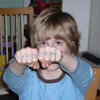
Silas’s idea of the ideal knuckle tattoo.
—orc Wed Oct 31 12:25:58 2012
I was going – late, but early enough to finish if I could do better than 4h30 – out the door to ride the Estacada 100 when I felt the front wheel go *squish* when it rolled over the stoop.
Oh oh.
It was noticeably low, and, of course, soft, and when I attached the pump to it to find what pressure it was at it cheerfully told me 20psi. Well, goddamn, that kills riding a permanent today – after popping the wheel, pulling the tube, inflating it to the point where I could find the leak, checking the tire for debris (no debris, but a nice little hole in the tread that matched the tiny little nick in the tire; I must have rolled over a piece of glass on highway 30 (maybe that’s why I was slowing down on the return from Sauvie Island?) and had the tire slowly bleed air for the rest of the day), booting the tire (with duct tape; it’s not much – I should cut apart one of the USPS priority mail kevlar envelopes I’ve been saving – but it at least puts some barrier between the tube and the puncture surface), putting in a new tube, and inflating it (twice; Nomad 28s won’t fit between the arms of my caliper brakes fully inflated) it was already past 10am, and even though I’m aiming for a sub-4 100k (again; my record was 3h41 on the Snooseville populaire after the 600 last summer, and I’ve hit 3h30 thrice en passant on the Sauvie Island populaire) I’m not comfortable trying to do it under the gun.
And I can’t do it this evening, because its Halloween and an early populaire would conflict with trick or treating, and a night populaire (particularly the Estacada 100) would conflict with holiday drunks on the highway.
Damnit.
I guess I’ll put my regular clothes back on and do some errands on the central east side. Maybe go up to Food Fight! and see what they’ve got for vegan fatty spreads for bread, bread pudding, and fruitcake (I have to go up there anyway to get some more hummus from King Harvest, and Food Fight is on a busy enough street so that I have a good chance of avoiding emotional trauma while I’m doing it.)
I checked my riding, and it’s only been about 680 miles between front wheel flats now (I’ve got about 2500 miles on the front Nomad, and didn’t have a front wheel flat until somewhat over 1800 miles on it. This compares favorably with the one flat/~500 miles on the rear Nomad) which is somewhat more frequent than I like, but these tires are baller enough so that I’m willing to put up with the flats in exchange for their ride, grip, and speed.
—orc Wed Oct 31 10:59:40 2012
Oct 30, 2012
My traditional speed limiter has been that I run out of breath and can’t actually get enough oxygen into my system to run my legs at my desired cruising speed, but in the last couple of months I’ve found that the things that fail first are my legs, which start to get tired well before I start gasping for breath.
This means that if I can coax my middle-aged (only if I live to 104, otherwise I’m old) legs into being able to produce more power, I’ll be able to shove my cruising speed up a ways before I start being oxygen-restricted again. And since my big rando goal now is to finish a populaire or 200k before the closing control opens (I’ve a way to go, since I’m still over 100 minutes above the opening time,) this is a good thing.
—orc Tue Oct 30 19:11:51 2012
As promised, I went out on a populaire (Kevin Brightbill’s Cuthbert Binns super-fast Sauvie Island loop.) The weather forecast called for occasional rain, but the “occasional” part turned out to be 3.5 hours of fairly enthusiastic downpour and 45 minutes of drizzle, which acted to slow me down to 4h12 loop time.
Nuts.
I did manage to discover that my Resist Nomad tires have way better handling in gravel than I do; the gravel section up to the nude beach has had new gravel dumped onto it, and this gravel is heaped up in drifts where the pavement turns to gravel. I hit one of the drifts at about 20mph and that sent the mlcm into a spectacular fishtail (there were a couple of points where I was leaned over about 20° as I turned into a skid, but the Nomads held tight and kept me from dumping) which I got out of just before I reached the side of the road …. at which point the tires slid out sideways into empty air and dumped me onto my left side, but fortunately only at about 4mph.
(And, also, when I was returning from the nude beach I encountered a couple of pheasants, who went galloping down Reeder Road ahead of me for about 150 feet before they decided that flying was a better bet. The male pheasant was running ahead of the female pheasant, and by the time they took off I was riding alongside her. I would have gotten a picture, except that (a) the L6 starts up very slowly and (b) I was too busy pushing into the rain and wind to think about it.)
And, after grinding out 70 miles, I’m much less wound up than I was yesterday. I’ve still got the same issues as before, but punching out a fast wet 100k makes a big difference in my attitude. Perhaps the Estacada 100 again tomorrow. It’s supposed to dump down rain again, but it’s not likely I’ll get much wetter than I got today.
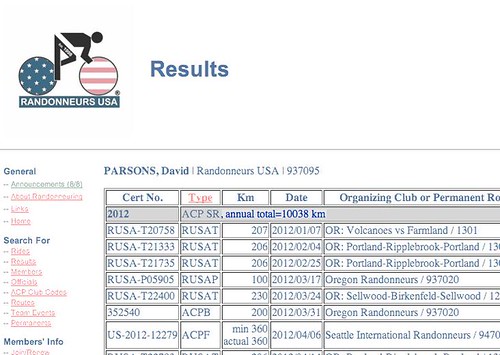
10,450 miles & 10148 RUSA km for the year.
—orc Tue Oct 30 15:42:46 2012
Oct 29, 2012
The fall rains have come in, and despite being on massive antidepressants I’m starting to slide right back into the black depression I was in this spring. I guess it’s time to throw myself into as much distance riding as I can wedge in over the next few days to try and kick myself out of it.
4×Estacada 100 this week, maybe, or switch between the Estacada 100 and Kevin’s Sauvie Island 110?
—orc Mon Oct 29 14:08:27 2012
Oct 28, 2012
Okay, so it’s the very end of October now, and the snowline has dropped below pass level on all of my alpine loops, so why am I looking at Portland-Portland-Portland and thinking that it would make a lovely November 600?
Am I
- Insane
- Itching for more longer loops
- Insane
- Really really wanting that third SR for the year (I’d need to build up and submit a winter 400k to do this. Lemme take a look at my Pacific City transit perms and see if I can find 30k and make a Big/Little Nestucca 400…)
- Insane ?
—orc Sun Oct 28 10:59:55 2012
Oct 27, 2012
My plan was to ride One Big Hill today, and I asked around to see if anyone else wanted to ride it as well (apparently nobody did; I asked on the orrando list and got a grand total of one “maybe” response. Oh well!) but when Saturday morning rolled around the alarm woke me to the sound of dripping rain, and with a nasty sinus headache, so I briefly considered the pros and cons to throwing on my clothes and heading for Silver Falls, then reset the alarm clock for 9am and went right back to sleep.
And by the time I woke up the second time, then by the time the antihistamines kicked in and I got warm enough to even consider going outside (I didn’t bother to put day clothes on, but went directly from naked to my geeky bike clothes. My cloud chamber jerseys are pretty good at keeping me warm when I’m wandering along country roads at 18mph, but not quite so good at keeping me warm when I’m sitting, shivering, in front of the computer. I ended up tossing on a fleece sweater to bottle in just a little more heat before I warmed up) it was already noon and there was not a chance in hell that I’d be making it back before it got dark at 6:30pm. So no 200 today (or 300, for that matter, even modulo the teeny detail that it’s teetering on the edge of the winter forest road closure) but instead something shorter.
Larch Mountain is, even now, likely to be a 7 hour round trip from Sellwood, and the Zigzag 160 is similarly long. I’m not going to ride the Dixie Mountain 100 by myself, so that leaves my newest 100 to ride.
It’s a bonus that I was fairly sluggish when I rode it on Thursday and I wanted to see if I could do better if I wasn’t feeling quite so achy. There was a 100% chance of rain, but that’s sort of the cost of doing business in Oregon in the fall/winter, and if I’m not used to it I’d better get used to it because I’m not going to stop riding until the day they put me under the knife to try to kludge my shoulder back together again (I am trying not to think about what’s going to happen after then, given that riding the fuck out of my bicycle is one of the things that’s keeping me from sinking into a black depression again.)
So I loaded up the mlcm with a long-distance load (I want to push up my moving average when I’m riding 600s, so I need to carry extra weight to make up for the 55 pounds of me that I am no longer carrying around) spread between my handlebar bag and the Carradice saddlebag I borrowed from Kevin and pushed off to ride east at about 1:45pm.
It wasn’t raining when I started, but sort of indifferently misting, so I didn’t bother to put on any rain layers before running out on Woodstock to the Springwater Trail. By the time I actually reached the Springwater Trail, the misting was becoming more serious, and by the time I reached the east side of Gresham the mist had converted to a moderate rain that was showing signs of becoming a serious one, and which provoked me to pull up under a shelter and toss on a light windshell (my rainjacket was such a disaster on the 700 that I didn’t want to use it unless it was an absolute emergency) which might get wet, but would at least block the wind after I got soaked by the rain.
And when I pulled out from the shelter, the rain had become fairly enthusiastic, so you can guess what my next move was: when I reached the end of the paved part of the Springwater Trail at Rugg Road, I did not dodge over to Telford but continued on into Boring on the gravel part of the trail, in the rain, through some fairly spectacular puddles and streams running down the right of way.
Amazingly, this did not completely soak me; my shoes and socks did not become completely soaked until after I was back on pavement in Boring.
After the control in Boring, I headed on the familiar route to Amisigger Road, Barton, and points south. It rained all the way down Amisigger Road, which kept my top speed under 50mph on the descent (and this time I stayed in the middle of the lane and avoided the bottle-ejecting bump that I found on the Tickle Creek bridge on my last trip) but, thankfully, had stopped by the time I did my first crossing of the Barton bridge.
From this point on to almost Estacada, I passed through little sections of rain, little sections of fog, and increasingly larger sections of dark gloom that did not contain either rain or fog. I wasn’t nearly as worn down as I was on Thursday, so the long slow climb up Springwater Road went by faster and I got into Estacada about 6 minutes up on Thursday’s ride.
Normally I’d take the chance to take pictures on the return from Estacada to Portland, but today I just wanted to put my head down and move as fast as I could, so I just went without sightseeing and/or pictures.
In Carver, I ran back into the rain, and most of the rest of the run back into Portland was done in the rain. And, annoyingly, when I reached Oregon City I ran into a headwind that stuck with me as either a headwind or a sidewind most of the way up to the Portland city limits.
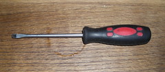
Along here I didn’t stop for anything. Well, anything except for this screwdriver I found lying on the street in Oregon City – I kited by it, registered that it was a screwdriver, and the stopped and walked back 50 feet to pick it up, because a sub-4 finish would be nice, but so is picking up rando junk :-)
I arrived back at the opening/closing control at, alas, 6:02, for a 4h17 loop time. Oh well! A 15mph brevet average isn’t that bad, but I’ve got to keep making runs at Springwater Road to see if I can improve my speed from the Eaden Road ramp up to Hayden Road.
Not many pictures this time (I didn’t want to take the camera out when it was raining on the way up, and I didn’t want to slow down to take pictures on the way back) but the few I took are on flickr.
10,350 miles for the year & 10,038 km of completed RUSA permanents/brevets.
—orc Sat Oct 27 22:46:09 2012
I was planning on riding One Big Hill to push myself over 10 megameters of finished RUSA brevets/permanents, but I woke up all congested this morning and my sinuses didn’t start clearing out until noon. So, instead, I went out and re-rode the Estacada 100 (trying, unsuccessfully, for a sub-4 finish) to just barely shove myself over the goal.
Maybe I’ll be able to do a 200 next Sunday (can’t do it Saturday, because I’m staffing the closing control for the Verboort Flat Tire Extravaganza!) to make up for falling down on the job today (or maybe I’ll try an early-morning re-rerun of the Estacada 100 tomorrow for another try at that elusive sub-4 finish?)
—orc Sat Oct 27 18:49:52 2012
Oct 26, 2012
Oct 25, 2012
I’ve been riding, almost exclusively, Kevin Brightbill’s two flat fast populaires during the week (I’m quite confident that, modulo late starts + flats, I can finish them in the ballpark of 4-4.5 hours) but have started to feel that I need to mix up my populaire-riding with a few different ones instead of repeatedly pestering Kevin to ride the same two loops over and over and over and over (I’ve not ridden either of those loops as many times as I’ve ridden Portland-Ripplebrook-Portland, but they’re both getting really close :-)
So I built up a couple more populaires of my own. One of them (The Larch, which climbs Larch Mountain) is just ridiculous and there’s no way on G-d green earth that I’ll ever be able to loop it in under five hours barring an extensive doping program, but the other one (the Estacada 100 is, for me, short and flat enough to be a good candidate for a sub-4 finish.
RUSA approved the Estacada 100 on Monday, right after I returned from riding Kevin’s Grawp! 700, so I decided that this would be a good week to do the checkride for it. I didn’t want to do it on Monday, because I was a little bit flattened from the 700 (which was considerably more difficult than Orrando’s summer 600, and not just because it was fall instead of summer) so I originally planned to ride it on Wednesday. But Wednesday was predicted to be rainy while today was merely going to be cold and foggy in the morning, so I changed my plans over and rode it today.
I started the ride at the crack of 9am, which means I actually left the house at 9:19, and set out into a thick cold morning fog. But when I climbed Woodstock up past Chavèz, I popped out of the fog at the top of the hill (40th) and flew east under sunny, but cold, skies. I made good time across Portland despite riding in city streets, and managed to notch my speed up a little bit when I switched over to the Springwater Trail, and made the 19 miles out to Boring in 1h12, which was pretty nice. I slowed a little
climbing up to Amisigger Road, but made most of that back when I plunged down the hill at 45mph (stopping, alas, at the bridge over Tickle Creek, because I hit an expansion joint the wrong way and ejected one of my water bottles onto the highway) and was thinking I was looking forward to a nice fast loop when I turned onto Eaden Road and discovered, to my dismay, that I had not fully recovered from the 700 when my legs knotted up and started howling with agony when I hit the first small ramp on the way up to the lower plateau.
Oh, dear. I thought this was because I hadn’t warmed up enough yet (I’d not done much riding on Monday, Tuesday, or Wednesday, so was probably a bit stiff) but, no, from this point on basically every climb became a slow painful cursing creep.
I managed to ignore the pain most of the way up Springwater Road, but that proved to be a miscalculation, because even though I made it into Estacada in 2h22, that blew up most of my legs and made the run back down into Portland much slower than it would otherwise be (all of the little hills between the summit of Springwater and Portland ended up being more painful than the hills flanking Boring.
I did manage to make it back in less than 4h30, though (4h28), so I didn’t end up being overly late to pick Silas from Llewellyn.
And it was a pretty ride, at least the parts I noticed when I wasn’t swearing my way up hills or down shallowly graded descents (A few pictures can be found in the usual place,) and it was enough to put this year’s RUSA total up to 9934km.
It’s unfortunate that it’s supposed to rain on Saturday, because that’s when I’m riding One Big Hill and I’d really hate to do a slow ride of that loop in the rain :-(
—orc Thu Oct 25 21:13:17 2012
Oct 24, 2012
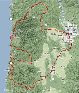
Prior to this fall, there were no 600+k permanents in the state of Oregon except for one that was part of SIR’s point-to-point from Washington State to Crater Lake. Now there are three; the SIR one, my Portland-Portland-Portland (which only got approved on Monday, which, alas, was after the snowline dropped below Cascade pass level and has either closed or made treacherous NF46’s pass between the Clackamas and Santiam watersheds. Oh, well, I’ll make it part of my (very late, after my shoulder heals) spring series) and Kevin Brightbill’s Grawp 711k extravaganza. Kevin and I have been goading each other towards 10k RUSA miles for the year (we are, I believe, currently the top two milage holders for Oregon; Kevin is the top milage holder for Oregon Randonneurs, and I’m about 1600km above him (I’m unaffiliated with any regional clubs, though when I rode organized brevets they were pretty much exclusively orrando ones)) and had been passing back and forth the idea of doing the permanent version of a Super Randonneur series (without, of course, getting any of the awards that RUSA or the ACP offer for completing a series of organized brevets; the motto for a Permanent Super Randonneur award would be “All of the fun, none of the credit”) so when his 700 was approved we had to ride it.
The original plan was to ride it on the 12-14th, but the weather forecast was for rain all that weekend but clear on the following (19-21st) one, so we pushed it off a week and rode my High Rock 300 for the last time this season (the high point of that ride is at ~4600 feet, and is sheltered enough so that whatever snow falls there stays there, as Ed Groth and I discovered last year when we did a checkride in June 2011).
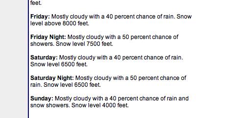
However, as the week progressed the weather forecast became progressively more gloomy, with it being a 50% chance of rain for friday,saturday, and sunday. And we were planning on a night start 700 (so we’d get to the overnight control in Oceanside before dark on Saturday) on Friday night. But the weather wasn’t getting any better, so we figured to bet against probability and just do it unless one of us injured ourselves, got sick, or had family emergencies. And, on Thursday, I got ready for the trip by running a fast populaire and borrowing a Carradice longflap saddlebag so I could carry a few more layers than I would normally carry. I’d bought a new pair of waterproof gloves & a rainjacket from REI, too, so I thought I’d be ready for most anything the fall could throw at me.

On Friday afternoon, I loaded up the mlcm and met up with Kevin for a 5pm departure. It hadn’t rained at all that day, but 30 seconds before 5pm it started to drizzle. Sigh.
But, anyway, off we went, riding south through Sellwood into Milwaukie, then up and along River Road to Oregon City, where we climbed up onto the Boring Lava with the route I traditionally take down – the steep 5th/Linn Ave ramp. About halfway up that ramp, we were briefly stopped by a police barricade because a homecoming parade was coming down the ramp. The police nicely let us pass, because we could thread the gap between the parade and the curb, and as we finished climbing the ramp we provided great amusement to the people on the floats, who cheered us on and/or threw boxes of candy at us as we worked our way up the hill (Kevin stopped and retrieved some of the candy, but I just kept plugging upgrade without stopping because I’d already filled my handlebar bag to overfilling.) Once on top of the lava, we headed south towards Canby, passing through spots of drizzle mixed with spots where it wasn’t raining at all, but as we approached New Era we dropped down to a bridge in the drizzle, but by the time we climbed up the other side of the valley it was seriously raining. So a brief stop (I’d pulled ahead of Kevin here, so it didn’t delay us as much as it would have otherwise) to put on the new raincoat, and then we forged ahead into the steady rain.
But, sadly, the rain didn’t stay steady; we made it almost all the way to Canby getting nothing more than damp, but as we crossed 99e the skies opened up and we were competely soaked by a torrential downpour, which held steady for about 4 minutes before we waded out of the downpour and headed, at a considerably reduced pace, through Canby and southwards again (we lost about 2mph moving speed here, and never really got it back. Ugh.)
The route from Canby to Salem is basically the reverse of the Orrando Covered Bridges 400 loop, so it was moderately familiar to me. Going south here, and without 300km under my wheels, is a long faster and less confusing than going north has been in the past, so I didn’t have much trouble navigating through here even though my night vision is such that I can’t really read signs unless I’m right up next to them.
We had a flat along here, which was annoying (Kevin’s rear Hetre collected a shard of glass, and, goodness, those tires suck up a lot of air before becoming even slightly inflated) but not overly so, because while we were changing the tube the sky cleared and let us travel the rest of the way into Keizer under the light of a quarter moon.
The first control was at a Safeway in Keizer, and we took advantage of this control to change out of our wet socks and continue on, still following, in reverse, the route of the Covered Bridges 400, slightly less damply.
At Independence, we headed west towards the Kings Valley Highway (along a route segment that we’d previously ridden on the summer 600) and into yet another band of heavy rain. Here I noticed an annoying thing; even though my gloves and rainjacket were keeping most of the rain off where they covered, I was still cold underneath them. My hands were dry, and the gloves had a nice fuzzy inner layer, but my fingers still got uncomfortably cold as the rainstorm progressed. And my jacket was waterproof enough to keep water from getting in (except at the collar,) but wasn’t particularly breathable, so everything inside it became very damp from sweat, which then had enough breathability to evaporate under my headwind and make the inside of the jacket very cold.
The rain had stopped again by the time we reached the Kings Valley Highway, but we still stopped at the Ritner Creek Bridge for a sheltered snack and relayering before we jumped onto the first scenic shortcut – Hoskins Road, which cuts off the extra distance of travelling down to Blodgett to get onto Summit Highway by the simple expedient of climbing across the mountain range directly to Summit proper. And it’s gravel, so a little harder to move at line speed on.
Halfway up the climb I needed to stop and strip off my rain jacket, which was interesting after I summited and followed Kevin down the other side, because the combination of cold+sweaty clothes+speed made me a very cold camper indeed by the time I caught up with him near the village of Hoskins. But I had managed to climb a pretty steep gravel ramp without stalling or spinning out, which was a nice change from the last time I came down here.
From Summit (the last 3 miles into Summit, on Mary’s River Road, were paved,) we dropped down into the Yaquina River valley and turned north onto Logsden Road at the village of Nashville. Logsden Road is nice in that it keeps people away from highway 20 (the main drag to Newport, so there’s always a lot of traffic on it; Logsden Road, on the other hand, had more deer/elk on it than it did automobiles) but not quite so nice because it goes to gravel where it climbs over Green Mountain. But that’s only a couple of miles, and then you’re basically going downhill most of the way to the Pacific Ocean.
As usual, it seemed to take forever to do the 18 miles or so of Logsden Road from the gravel section to Siletz (it’s odd, because it runs through pretty countryside; even when it’s daytime it takes forever. At least it was close enough to dawn here so that we kept flushing deer out as we rode along – there was actually a point where I was riding ahead of Kevin where I flushed out a pair of deer who ran down the highway ahead of me for a little while before bolting into the underbrush to my right,) and it kept getting colder and colder as we wound along. We reached Siletz just after 5am, which was nice because the Little Chief Cafe opened at 5, and we could stop and have a leisurely warm breakfast before continuing. There’s not much I can eat at rural restaurants these days ‘cuz vegan, but hash browns, oatmeal, and coffee are widely available and I like them.
The staff and customers there seem to be used to seeing bicyclists come through, because they didn’t bat an eye at us except when we said we were trying to go from Portland to Portland in one go via the scenic route, at which point they were suitably impressed. And they didn’t mind when we stayed much longer than it took us to eat (we needed to get/put things on the bicycles, and every time we went outside it was “oh, lord, it’s cold out here” and we’d bolt back inside for another five minutes) and wished us luck when we finally pried ourselves out the door and onto the bicycles again.
From Siletz, we followed highway 229 north and towards the Pacific Ocean. It winds along the Siletz River, so you’d think it would be moderately level, but, no, it spends a considerable amount of time winding up and down various hillsides as it proceeds along (this explains why I thought during the 2011 600 that 229 went up to a plateau from the coast, then went through another range of hills before it reached Siletz) and I kept finding myself getting lost in thought, cranking up and over a bunch of ramps, then looking back to see that Kevin was a considerable distance behind me. *sigh* The morning is usually when I brood over things, but I don’t usually do it at 17mph.
It wasn’t raining, just cold, but sadly that would not last. As we turned towards the ocean (after 15 miles or so) we went under the edge of a marine effect storm, which was, at least here, cheerfully dumping rain upon our heads, and by the time we reached highway 101, we were both pretty soaked (me more than Kevin – he managed to score an experimental Goretex jacket as part of a test that Team Estrogen is running, which meant that he didn’t have nearly as much of the hot/coldhouse effect inside his clothing) and fairly chilled. My fingers were freezing at this point. They were still dry, but there was enough moisture in the waterproofing layers of the gloves to wick every bit of heat out of them, even with a pair of liner gloves to try and coounteract the coldification. But at least it wasn’t raining at highway 101, so we managed to dry out a little bit in the mile or so we stayed on that road, and for the first 5-6 miles of our run back into the mountains on Drift Creek Road, Anderson Creek Road, and the first 100 or so feet of Schooner Creek Road (aka NF 17.)
But after that 100 feet, two things happened. First, it started to dump down rain again, and second, the pavement ended and it became a gravel road (for the next 10-11 miles, too.) We first tried to park ourselves under the canopy of a tree to wait the rain out, but when the rain didn’t stop we said “to eff with it!” and waded out into the deluge and headed east (and up) along this scenic logging road.
And it was scenic. Now that I’ve got tires that are nimble on gravel, I can chug uphill on moderate grades at close to the speed I do on pavement, so I managed to pace Kevin eastwards and we came out from under the marine effect storm in almost no time. And then it was just winding upgrade on a thankfully not washboarded gravel road through regrowth forest, clear cuts, and the occasional house where the road came out of the national forest and into private lands. The summit was paved (it’s out of the forest, and there are about half a dozen houses here) but that pavement ended before the descent, which was, once again, gravel, but washboarded this time. Kevin vanished ahead (a theme on gravel descents on this loop) and I plodded along more slowly, looking cautiously for gullies and similar shoulder-separating obstacles, and caught up with him as he waited at the bottom.
And then we turned back and headed for Slab Creek Road along highway 18.
There are a couple of businesses at the intersection of highway 18 and NF12/Old Scenic 101 (which is what Slab Creek Road becomes when it summits Cascade Head) and we stopped at the Otis Cafe for a second breakfast and a change into our last pair of dry socks. The storm was no longer threatening to the west (it was, apparently, being blocked by Cascade Head) and the clouds had broken up so it was actually intermittently sunny, and we worked our way up the south side of NF12 without even breaking much of a sweat.
Slab Creek Road was, once again, the lightly graded route that I remember from this summer, and I’m going to have to make a 600 of my own that uses it one of these days. And where it dropped us onto highway 101 again there was a nice wide clean bike lane that took us all the way to the next control in Pacific City.
From Pacific City, it’s only about 22 miles to Oceanside, where the overnight control is. 22 miles by the direct route, that is; Grawp takes a far more scenic route by going back south to highway 101, then crossing the Coast Range (via the Little Nestucca River Highway and Hebo Road) to Willamina, then returning via Bible Creek Road (etc) and the Nestucca River Road, which makes it more like 90 miles.
Oh well, we’re doing this for fun, and it’s now a nice warm sunny day, so it’s not a problem.
We shot (fsvo “shot”) east up the Little Nestucca River Highway, then dropped down into Grand Ronde on Hebo Road (which is still annoyingly grooved, but I’ve gotten better at pointing the mlcm between the ruts) and crossed to Willamina on, first, Highway 18/22, and then on Yamhill River Road, which is much quieter because it’s been cut at Highway 18/22 (we needed to hikeabike down an embankment to cross over to it, but that was only about 50 feet) and now has almost no traffic on it. We stopped in Willamina for the control and a snack (grocery store bananas and jellybeans for me, ‘cuz vegan (ish: I’m not sure about the origin of the food colors in the jellybeans. I’ll check that before the next 600)) before turning around and heading west again.
The pass at Sourgrass Summit is quite low and the approaches to it are fairly gently graded, but going back via the Nestucca River Road is not either of those. The traditional route of taking Meadow Lake+Nestucca River across is quite steep and climbs to about 2000 feet, and the route we were taking cuts off a couple of hundred feet from that summit.
But it cuts that off by first a dozen or so miles of fairly easily graded climbing along small rivers, then diverging and doing basically directly up the mountainside on Gilbert Creek Road (Gilbert Creek runs somewhere off to the west of Gilbert Creek Road, but I don’t think I would have noticed it if we were riding down the streambed) which resulted in some of the most horrifically steep climbing I’ve ever done. First you climb about 800 feet via super-steep ramps (15-20% grades) connected by short level(ish) sections, and then, once you enter BLM lands, it settles down to a constant climb of 7-10% for another 600 feet or so. The only saving grace of this insane climb is that there’s an almost identical descent on Bible Creek Road on the other side of the pass, which is great fun on a sunny day.
Alas, this was not a sunny day; as we climbed Gilbert Creek Road, clouds started to press in, and almost at the point where we tipped over the top and started to descend the spigots opened and freezing cold rain dumped down on us. So what would normally be a thrilling plunge down the side of a mountain became instead a white-knuckled attempt to creep down as debris sluiced across the road around me. Kevin, thanks to somewhat more worn brakes, vanished ahead of me during this descent, but I had quickly become so cold that I would not have been good company anyway.
When I reached the bottom of Bible Creek Road, I was chilled to the bone, and couldn’t warm up for the life of me – if I sprinted, I would warm up during the sprint, but then as soon as I slowed down I would be freezing cold again. We’d been planning on just riding directly through to Oceanside, but when we reached Beaver I had to stop and get some warm coffee and sit inside a warm building for a while before we could continue.
After about 20 minutes, we headed out again. It was not raining here, so the last (20, I think) miles started uneventfully; Highway 101 has horrible shoulders here, so the first 4 miles involved a lot of jockeying for position between us and the automobile/truck traffic, but not annoyingly so, and those four miles passed pretty quickly, as did the run up to Cape Lookout on Sandlake Road. Climbing Cape Lookout was actually not that bad (it’s more gradually graded from the south than from the north, so we could make pretty good time up it despite the 260 miles we already had under our wheels) and the descent down the other side was okay (the road is not in the greatest of shape, so I proceeded fairly cautiously down the ramp to where Kevin was impatiently waiting at the bottom. And then it was a simple run across to Oceanside along Netarts Bay.
So, of course, it started to rain, and then to pour, and then to hail, all of which was coming horizontally in from the direction of the Pacific Ocean. We were, of course, once again soaked, but this time I had the unpleasant feeling of having first my left side get soaked, and then feeling the wet creeping across my body to my right side. But, thankfully, we were almost to the overnight control, which, happily, was Kevin’s grandmother’s house right on the beach in Oceanside, and, more importantly at this time, with showers and clothes washers, so we could clean ourselves and get our clothing clean and dry before heading out into the weather again. (Plus we were fed, and got 2h15’s worth of sleep before eating again, loading our now clean and dry clothing back into our bicycles, then heading out.)
Refreshed, we rode out into the night, warmed ourselves up climbing Cape Mears, dropped (quickly and slowly) down the other side, and then rode around the back side of the cape into Tillamook, where we were planning on stopping briefly at the 24 hour Safeway there so Kevin could grab a space blanket and I could, I dunno, pick up some more sweets to snack on. But when we got there, we discovered that the “24 hour” part was a cruel lie and the store was closed. We stopped anyway, because it was starting to drizzle again and we wanted to get raingear on to avoid getting wet, then headed north along Highway 101 towards the Miami-Foley Highway (and then Foss Road, which, alas, we thought we’d transit in the dark and miss the scenery.)
Amazing how plans can change. The rain had been gradually getting stronger (to the point where I actually considered recommending that we pull off the road and shelter for a while in Bay City, but decided not to because we weren’t getting particularly wet) but when we were about halfway between Bay City and Wheeler it took a nasty turn for the worse – first the spigots opened and we got nailed with horizontal rain from the ocean, and then when we were thoroughly soaked it turned into a savage hailstorm that dumped enough hail to put between a quarter and half inch of hail on the ground.
Of course the hailstorm happened between towns, so there was very little shelter. When we reached the Miami-Foley Road, we ducked under a tree when the hailstorm slackened, but as we shivered there the hail intensified again and forced us onto the move again. A few miles on we reached the end of the marine effect storm and the hail cut out as if it had been sliced off by a knife, but then we worked our way along in freezing rain. We tried to shelter under another tree, but the wind blew the rain sideways enough to get us wetter, if that was at all possible, so we headed out again.
I do not like these REI waterproof gloves I purchased, nor do I love the REI rain jacket I purchased either, because they seemed to be engineered to suck in and trap cold, no matter what layers I had underneath them (wool gloves under the waterproof gloves didn’t work, nor did the three layers of wool (baselayer, cloud chamber jersey, thick Portland Cyclewear jersey) under the stupid rain jacket. And it didn’t take much more than about 5 miles after we were forced out from under the second tree before the rain stopped, the wind came up, and I started to seriously freeze, to the point where I was shaking enough to have trouble steering the mlcm. Kevin was far in the lead here, and I didn’t think I could safely catch up enough to tell him we had to look for shelter now, so I hopped off the bicycle and began to briskly walk it down the highway.
Riding a bicycle is a very efficient way to move around. Walking, not so much, which would normally not be a good thing, but at this point it meant that I was producing a lot of heat and not moving fast enough so that the horrid raingear I had would wick all of it away. So after a mile or so, I stopped feeling like I was hypothermic and was merely really really cold (at which point I caught up with Kevin, mentioned that I was feeling hypothermic, and we needed to find a sheltered place ASAP so I could warm up a bit.)
There are not that many open barns along the Miami-Foley Road, so we walked (and rode when I’d warmed up enough so I could ride without immediately freezing) another couple of miles before we saw a farmyard that (a) didn’t have a fence and (b) did have an open-sided shed right near the road. So we scampered in there, I took off the stupid jacket and gloves, pulled out my space blanket, wrapped it around myself, and scrounged up a bunch of food from inside my handlebar bag so I could crank my metabolism up to maximum heat production.
After 45 minutes or so, I was feeling less like a potential icicle, so we gathered up our stuff and headed out. But before we headed out, I shredded my mylar blanket and made a tinfoil hat to go under my cap and a tinfoil vest that went under my windvest, which was gratifyingly warm and warmed me up to the point that I was comfortable within a dozen miles.
But before that dozen miles we reached the end of Miami-Foley Road and turned right onto Foss Road, which was easily the high point of the loop. Foss Road starts out paved, but painted onto the side of the bluffs along the Nehalem River (the ex-POTB line to Tillamook runs along the river, but is in pretty sad shape these days – it’s covered with landslides and other debris now, and would take a considerable effort to get effort to put back into service again) but then goes abruptly to being a muddy path that is also painted on the bluffs along the river. Part of it used to be paved, because large stretches of it are partially paved with disintegrating asphalt, but most of it is gravel, stones, and mud.
But it had stopped raining, it was dawn, the scenery is spectacular, and I’ve got baller tires on the mlcm these days. So I could charge along after Kevin (on flats and upgrades; my shattered shoulder slows me way down on gravel descents, though I was moving a lot faster downhill after the Nomads demonstrated that they have excellent adhesion on rough surfaces (demonstrated by me not washing out a couple of times where I pulled the bicycle hard to one side or another to avoid a pothole; I could feel the wheels break loose, slide a little sideways, and then grab onto the gravel surface again before sliding out from under me.)
As I accelerated up a loose gravel ramp, the thought came to my mind that this must be what cyclocross is like, which is a dangerous thought for a middle aged ex-programmer with a shattered right shoulder.
This went on for about 18 miles before we came to the end of the gravel section (after a couple of false alarms where the road went to pavement for ¼th to ½ mile before going back to gravel) and were back on pavement for most of the rest of the loop. But by this time we were actually riding below brevet minimums, and, even though Kevin said he’d let us blow one control as long as we made up for it on the subsequent ones, I wanted to see if i could get to the control before it closed.
It was 5 miles away, mainly uphill, and there was only 18 minutes left until the control closed. I didn’t make it, though I came pretty close (this control is at the store+restaurant on Highway 26 at Jewell, which is about 600 up from the Nehalem River, and Foss Road goes up and down a few times here as it cuts across a couple of meanders before ending at Highway 26.) And then we lost another half an hour warming up before continuing onwards.
I’d never been on highway 103 before – it’s pretty nice. It’s not so much a country road as a suburban road; Jewell spreads along the road between Highway 202 and Highway 26, and rural fields are intertwined with country houses, farms, and schools, and the occasional business. And then, on 202, it’s only 20 miles over to Birkenfeld and the familiar (from the Birkie 200k that Orrando used to run) route on 202/47/Timber Road over to the Gales Creek Road and new roads east.
202 undulates a bit between the junction of 103 and Birkenfeld, so I opened it up on some of the climbs and pretty soon dropped Kevin, getting to the Birkenfeld store about 10 minutes before he did. I tried to restrain myself after then, but the chain on the mlcm was starting to get squeaky and when I was pulling Kevin down the road the rhythmic squeak-squeak of the chain was very lulling and I found myself actually falling asleep while riding down Highway 47, so I had to give up and either follow him or ride alongside for most of the way into Vernonia (when we got within 5 miles of Vernonia, I bolted ahead so I could stop at the Shell station there to grab some caffeinated soda and not delay us too long) and then, after Vernonia, we had just turned onto Timber Road when we went over a bump and my rear rim went scrape against the ground.
Oh, shit, another flat. I popped the rear wheel, found the puncture (a piece of beer bottle had daggered through the tire and into the tube) patched the tube, reassembled everything, and we were on our way. I was hurrying a bit because of this unexpected stop, and found that I had dropped Kevin before we even reached the Highway 26 crossing. Oh well, I might as well bolt over the mountain as fast as I can go and wait for him at the Glenwood control. (Or, as it turned out, I might as well stop and reinflate the rear tire when it went flat again just before Timber, then sprint as fast as I can the rest of the way to Glenwood so I can pop the wheel and put a different tube in before Kevin caught up. That almost worked; Kevin rolled in while I was still investigating the tire for additional pokey things, but he had cleaned out his handlebar bag and needed a lot of food now, so he bought food at the control and ate while I put in a different tube and reassembled the wheel.)
After Glenwood, we stuck together for the rest of the loop. We diverged from Gales Creek Road at Clapshaw Road, which is part of the most direct route across the valley that doesn’t involve riding along highway 26. There’s the tiny detail of having to climb up the cliffside that makes the west side of Clapshaw Hill (300 feet of hill with a really steep switchbacked road winding up it. Average 15% grade, maybe more – it starts out with a 20+% pitch, which drops down to “only” 10%, and then pitches up to around 20% again. I punched it and charged to the top of this hill as fast as I could go, but that ate up the remaining bits of my climbing speed right there) but once that was over it was a fairly level ride across the valley to the west hills. Night was creeping in as we rode across the valley; we reached North Plains at dusk, but by the time we reached Jackson Quarry Road it was nighttime and we finished the loop in the dark.
When we reached the last climb (Laidlaw/Thompson to the top of Tualatin Mountain, then Thompson/Cornell back to the bottom) I was starting to feel the effects of not having enough sleep. I was starting to have visual hallucinations, mainly perspective and imagining constructed artifacts from tricks of shadow and branches, and my energy was dropping off at an appreciable rate. I took this hill slowly, lagging well behind Kevin until near the top, when he ran out of steam (because he was big-ringing his way up the hill) and I churned past him in an embarrassingly low alpine gear. Going down the hill was worse, because Thompson is fairly twisty on both sides of the hill and I didn’t want to misjudge something and end up hurdling off the side of the road at 35mph, so I ended up liberally applying the brakes and creeping down the hill at maybe 20mph.
And then we were effectively done. A quick (for values of quick that include urban areas) transit of NW and downtown Portland, across the Hawthorne Bridge and over to Division Place, then up 8th to the Powell St. pedestrian overpass, across it, up 8th again to Boise, then into the final control, where I quickly signed and dated my brevet card, handed it over, and bolted for home with a “thanksbutIgottagoweshouldridethisagainwhenit'ssummertime!”
The final tally: 52h11 to ride 712km; a brevet average of a whopping 8.4 miles per hour (my moving average was a little more than 14mph, shockingly, given that it took us 4 hours to go 15 miles on the Miami-Foley Road.)
What worked? Almost everything. The historical reenactment bag I borrowed from Kevin was very nice for carrying extra clothing, despite weighing approximately 500 pounds, and I didn’t really feel it when I was trundling around the countryside. I can’t really say whether the Atac clipless pedals worked or not, because I wasn’t stomping on it all the way around the loop, but I did spend about 46 hours on the bicycle this weekend and my feet didn’t hurt, and that is after doing a 17.1mph brevet average populaire on Thursday. My layering worked, the mylar blanket worked, my food selection worked (all vegan, as far as I know; I can go a long way on potatoes, oatmeal, bagels, nuts, science diet, and vegan candy,) and, really, the only thing that didn’t work were those stupid REI waterproof gloves and rain jacket, which came really close to jeopardizing my life after the hailstorm on 101/Miami-Foley Road.
I’m now at 10200 miles for the year, and 9730 RUSA km. I’ll be over 10k/10k by the end of the weekend (I’m going to ride One Big Hill on saturday, probably by myself, and I’m going to do the checkride of my Estacada 100 tomorrow morning, so, modulo DNFs, I’ll have 10134km by next monday) and then the only bikey project I’ll have left is to see if I can get over 20,000km for the year (12400 miles; two months at 1000 miles a month in winter? That’s maybe doable, provided I’m not taken out by a nasty fall flu.)
Oh, yes, and I’ve now got two SRs for the year. One “official” ACP SR, and one Permanent SR (which isn’t recognized by anyone except me :-) If I was completely insane, I’d try for a second Permanent SR by reriding Hot Springs/Covered Bridges and Portland-Portland-Portland in the next three weeks (while there’s still a fighting chance of being able to get through the snows at the summit of NF 46) but I don’t know if there’s anyone I could convince to come along with me on this project.
Pictures? Check the usual suspect for them.
—orc Wed Oct 24 23:43:47 2012
Oct 22, 2012
I rode Kevin Brightbill’s Grawp this weekend; 52h11 total loop time (loops longer than 699km enjoy a relaxed minimum speed, so we had ~54 hours before the final control closed, and we certainly took advantage of that extra time) and now have two 2-3-4-6 series for the year; an ACP series of brevets and a PSR series of 1-2-3-4-6 permanents. This ride brings me up to 10200 miles of riding this year and 9830km’s worth of finished RUSA brevets/permanents, with over two months still to go until the year staggers to an end.
This was possibly a bit late in the season to ride longer loops. It was cold for about 40 hours of this loop (only warming up Saturday and Sunday afternoons when the sun came out) and there were savage rain and hailstorms on Friday and Saturday night (Friday was annoying, because it first started to rain just as we left the opening control at Milwaukie & Bybee, and that converted into a slashing downpour with about 5' visibility in Canby, and then, after stopping for a few hours, we got another round of it as we were going west from Independence to the Kings Valley highway – fortunately the Ritner Creek covered bridge exists, because we were able to shelter under it and relayer with drier clothing before heading west towards Hoskins Road (first gravel stretch; a honkingly steep ramp up the side of the Coast Range to Summit – but the Saturday ones were downright dangerous. We were dumped on with freezing rain just as we reached the Bible Creek Road descent from Bald Mountain, and my allegedly waterproof REI gloves and raincoat immediately failed, so I froze my butt off to the point where we had to stop in Beaver for about half an hour to thaw out, and then we got another one as we transited Netarts Bay towards our overnight control in Oceanside, and finally, just after we cleared Bay City on the way back towards Birkenfeld, we were absolutely nailed by a hailstorm that left between a quarter and half inch of hail on the ground and, once again, soaked me to the skin. We spent about 4 hours on the Miami-Foley Road scrambling from one sheltered spot to another, and finally found ourselves holed up for a while in a barn while I wrapped myself in a space blanket and crammed food into myself to push my metabolism up to high heat production. I was most certainly colder than I’ve ever been, and that includes the DNF on the Barlow 300k. When Kevin finally pried me out of the barn, I cut apart the space blanket and went to full tinfoil by putting a chunk of mylar under my had and then wrapping a bigger chunk around my torso before putting on my actually windproof vest. I’m sure I looked somewhat ridiculous, but, shoot,. I was nice and warm!)
That was probably the low point of the trip (Kevin thought I was going to DNF just before we found the barn; I was more worried about actually freezing to death, though once I got off my bicycle and started walking I was producing more heat than was being sucked away by the wind and thus my fears were possible a bit overblown.) The high points of the trip were, I think, the gravel sections, which were made not exactly easy (can’t get 20mph in gravel no matter how I try) but actually fun by the 28mm Resist Nomad tires I’m using on the mlcm these days. The climb on NF 17 was a blast because I could actually open it up and climb at close to my pavement climbing speed through this spectacularly lovely stretch of coastal forest (there was actually some snow on the ground here) and Foss Road was a spectacular rollercoaster ride where I was regularly accelerating uphill on loose gravel (and only had to walk one particularly steep ramp because I was unable to finesse my pedaling enough to continue to move without spinning the rear wheel on the gravel, mud, and fallen leaves) – The Nomads are actually surefooted enough so I could do some fairly drastic maneuvering to get around potholes without having the tires wash out on me and dump me into those potholes.
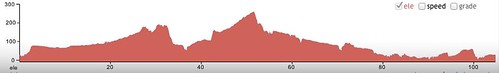
The insane parts of the loop were the climbs. Ridiculous climbs, ranging from the regular super-steep gravel climbs on Logsden Road and Hoskins Road (the traditional “we’ll put switchbacks in because we can’t get the road surface to stay in place when we paint a line directly up the mountain) to the mindbogglingly steep climb up Gilbert Road, which is a 3-4 mile stretch that was painted directly up the side of Bald Mountain (it was paved, so they could do that) – imagine, if you will, a climb that starts off with 800 feet of 15-20% ramps with very short stairsteps between them, and then finishes with another 600 feet of a steady 8-10% ramp, and then, in the last 40 miles, a climb up Clapshaw Hill (a steady climb that varies between stupidly steep and insanely steep; you’re climbing one of the insanely steep pitches and the stupidly steep one ahead look level, but, no, you’re still going to be climbing in your alpine ring and you won’t be very happy about it) followed by a climb up Laidlaw and Thompson to get to the top of the west hills (I walked one of the pitches on Laidlaw, because I’d been sprinting up all the other steep ramps on the loop and was getting kind of tired after about 56 hours with only 2 hours of sleep.) Ridewithgps claims 7600 meters of climbing on this loop, and I’m tired enough to believe it.
I will post more about it later, but I’m a little too tired to do so now.
—orc Mon Oct 22 13:29:43 2012
Oct 19, 2012
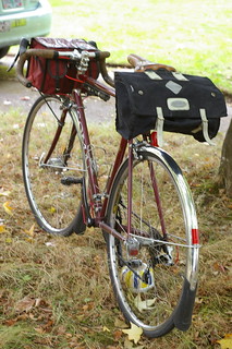
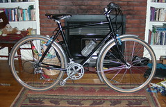
The midlifecrisismobile, weighted down with a Carradice longflap saddlebag. G-d, canvas luggage is heavy – I’m going to have to make a note to sew a duplicate out of cordura or some space-age fabric so I can have a less-heavy bag for the next long brevet (the next after this afternoon’s 700) I ride.
—orc Fri Oct 19 14:05:25 2012
Oct 18, 2012
With the change in the weather this last week I hadn’t been doing much riding, which isn’t necessarily a good thing because there’s the tiny detail of one last big brevetpermanent that’s gonna happen tomorrow at 5pm (if you’re riding 712km, why not start at 5pm? This means that two of the three gravel sections – Hoskins Road and the Logsden Gravel – will happen at night, so it’s as if they won’t even be there.) So I needed to get out to stretch my legs once during the week, to at the very least shake the cobwebs out of my brain and get me out into the country.
So I decided to ride on up to Sauvie Island again, because it’s a nice fast loop and even when I’m sluggish I can generally make it around in 4.5 hours modulo flats. I had a telephone errand to run, so I didn’t get out the door until about 9:15 (I actually locked up at 9:12, and sat on the front sidewalk until 9:14, at which point I started the brevet clock and headed north.)
It was cold (45°F) this morning, but not at all cloudy in Portland proper (the weekend rain didn’t come in until tonight) so I felt pretty sluggish as I worked my way north from Westmoreland towards downtown. Unlike yesterday’s trip up to the central eastside, I did not feel sprighty and full of vigor, but felt as if I was just sort of plodding along.
As I worked my way through downtown (across the Hawthorne Bridge, then north on Naito/Front to Kittridge) I slowly warmed up and started to feel like my normal self again, which was good because there were interesting railroad things to photograph as I went. (But, alas, the railroad photographs were the last I took because the batteries went dead in the camera!) I could see every now and then a bank of very dark and damp looking fog to the north of me, hovering ominously over Sauvie Island, but but by the time I’d reached Linnton the fog was starting to look a little moth-eaten under the impact of the sun – when I passed under the St. John’s Bridge, I could see a fairly substantial tongue of fog across Highway 30 approximately in the middle of Linnton, but by the time I reached Linnton that fog was gone and I could see the near banks of Sauvie Island clearly.
When I finally crossed over onto Sauvie Island, I briefly went under the fog – two miles of really chilling damp cold between the Sauvie Island bridge and the little town at the corner of Sauvie Island Road and Reeder Road – but I passed back into sunshine as I worked my way north on Sauvie Island Road. It’s fall now, and the fields have all been harvested and many of them have already been ploughed for the next crop (winter wheat? more corn? I dunno) and all of the farms with pumpkin patches have them in full operation. There was maybe the slightest headwind as I went north, but it faded at the Sauvie Island Road turnaround and became a lackadaisical crosswind for the rest of the morning. And then south, back down to Reeder Road at a somewhat slower (19mph instead of 20mph) speed, and across and up to the nude beach info control on the northeast.
It was fully sunny now, and I wanted to get some more pictures, but, alas, I could not :-(
But in any case I got up to the nude beach info control (41 miles from home) 2h23 after I set out, which was a pleasantly fast time (I was averaging something over 18mph brevet time here, which was nice) but on the way back my body started gently reminding me that I was possibly working too hard by slowing right on down – I found myself actually having to push to keep over 18mph now, and after I’d wrapped around the bottom of the island and reached the bridge for the return I found that ramp to be a lot more difficult than it had been on previous loops (slowing to about 9mph to climb up to the bridge.)
Highway 30 was, as always, a pleasantly fast return loop, but I proceeded a little bit more cautiously because I didn’t want to ram a field of broken glass or any other sort of tire-eating debris. But, despite all this, I zipped back into town at a pretty good rate, ignoring the scenery and occasional train in favor of watching the road ahead of me for tire-eating debris, and cleared 100km after about 3h33.
And then I started to hit stoplights. Most of which were turned red. And the next 30 minutes were, as usual, a festival of stop, then creep away on the green light to the next stoplight, then repeat. Ugh. It’s a fact of life that brevets/permanents with city sections are going to be slowed by the lights, but it was still somewhat annoying to be spending all this energy accelerating away from one traffic control or another.
I reached the closing control, alas, 4h03 after I started out, with 2km (1.25 miles) of bonus milage bringing my loop time down to just over 4 hours.
Drat. Oh, well, I’ll try to push my moving speed up .1 mph next time I do this loop (the last 4 times I’ve done this loop have finished in 4h04, 4h11, 4h21, and now 4h03. There’s got to be a sub-4 in me somewhere close at hand!)
After doing this loop, I have ~9750 miles ridden this year, and 9118km of completed brevets/permanents. And it’s not going to be too long before I’m over 10k miles this year (possibly by the middle of the day on Saturday?)
—orc Thu Oct 18 23:12:25 2012
Oct 17, 2012
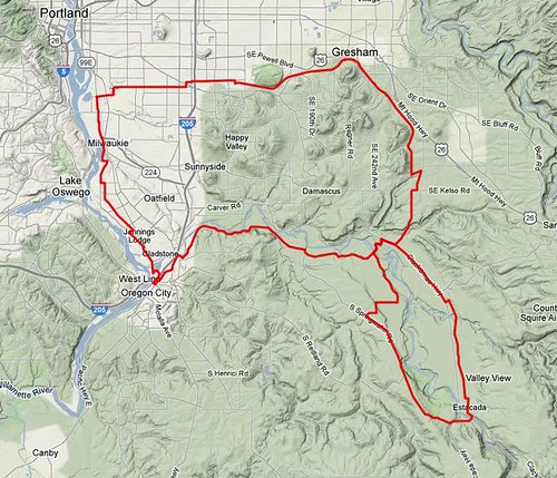
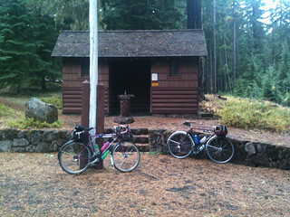
This is my idea of a flat loop. There are only three steep ramps on it (Woodstock just east of Chavez in Portland, Eaden Road just before climbing up to Springwater Road and the Broadway cliff in Estacada) and the rest of it is either flat or fairly gradually graded. It starts out, as is traditional, at Milwaukie and Bybee, but instead of going south it goes directly east on Bybee, around the Eastmoreland golf course on 28th, then east again on Woodstock out as far as 87th, where it zigs north onto quieter city streets for the last couple of miles out to a connection with the Springwater Trail.
The Springwater Trail takes you east through Gresham, then south into Boring (the paved part of the trail ends at the Multnomah County line; you can continue into Boring along the unimproved railbed, but the cuesheet directs you onto adjacent roads) where the first control sits. And after the first control, it follows (the all too familiar if you ride a lot of my permanents route on) Ritchey, Kelso, and Amisigger Road down into the Clackamas River Valley, and then dumps you onto OR-224 for a mile and change until you reach the town of Barton, where you abandon the highway for Baker’s Ferry Road, and then, almost immediately after crossing the Clackamas, you abandon Baker’s Ferry Road for Eaden Road, which is a nice quiet loop along the lower bluff top by the Clackamas River, with only one honkingly steep ramp where it climbs up to the upper bluff where Springwater Road runs.
Springwater Road takes you south again, climbing slowly, up until you’re parallel to Milo McIver Park, where you turn off onto Hayden Road and then plummet about 700 feet back down to the Clackamas River and the next control in Estacada. If you’re not in a hurry, there are some nice brewpubs, coffeeshops, and restaurants here (and why be in a hurry? The climbing is pretty much all done now and all you’ll see, after you winch your way up the Broadway cliff, is rollers and river crossings.)
The route back from Estacada attempts to avoid Highway 224 as much as possible by taking Eagle Creek Road instead. There’s a pretty steep ramp in Estacada (Broadway attempts to go directly up the bluff from lower Estacada to upper Estacada) that may see you dropping into your alpine gears, but once you’re up there it’s generally downhill, with a few rollers, all the way to where you have to leave Eagle Creek Road and get back to OR-224 so you can run up into Barton (and then across the Clackamas on Baker’s Ferry Road) for the second time in the day.
But this time you’re not going on Eaden Road. No, you climb up to the top of the lower bluff, and then scoot along the edge of it back to Springwater Road, which you take north and west into the little town of Carver, where you join Clackamas River Road for a pleasant, if somewhat trafficky, section that runs through farmlands, then alongside the Clackamas, and then through suburban estates until you climb a short ramp, pass a water facility, and are popped right into Oregon City proper.
The state of Oregon has just finished spending a large sum of money to redesign the highway intersection here to make it easier for Clackamas County commuters to get up into Portland, but one of the side effects of this is that what used to be a grade crossing of Highway 213 is now an underpass, so now Clackamas River Road runs into a roundabout, and when it comes out it’s Oregon City’s Washington Street. There is a bike lane here, but it’s not particularly good (the road surface is pretty terrible, and there are drifts of tire-puncturing debris scattered here and there along it. Ask me how I know about that!) so you might want to ride, cautiously, in the traffic lane until you reach the open control around 15th St, where you leave Washington and connect to Main St and the north.
Normally I route people on Main Street to an access road for the Oregon City Shopping Center, and from there onto 99E up to River Road (the less-trafficked way into Portland) but there’s a better way to get there; there’s a MUP that connects Main Street from the old stub of Washington Street (Washington Street used to, before the interstate highway severed it, connect to a bridge into Gladstone. That bridge has been abandoned to auto traffic and is now only used as a ped/bike bridge, and it gets you across the river and onto Arlington Ave (which turns into River Road at 99E) and keeps you from having to do a left turn across a major highway.
You take River Road for a mile or so north, but then jog to the right and onto the newly opened Trolley Trail (another abandoned Portland Traction ROW, just like the Springwater Trail) which goes in a much more evenly graded manner all the way into downtown Milwaukie. Or at least it will go all the way into Milwaukie when the last mile is finished, but for now, after a few evenly graded miles on the Trolley Trail you jog back to the left onto River Road, then plunge down off the point of land south of downtown Milwaukie in a much more precipitous manner.
And once you’re in Milwaukie, you’re just about done. It’s about 3 miles up to Milwaukie and Bybee again, and it’s just one road (17th Ave, which becomes Milwaukie Ave about a mile into Portland) all the way there.
(Once it’s approved, I’ll publish a copy of the cue sheet. But for now you can look at the prototype map on bikeroutetoaster.)
—orc Wed Oct 17 23:01:32 2012
Oct 16, 2012
In the past few years, I’ve ridden 1-2000km’s of brevets/permanents, with the vast bulk of them being organized (ACP/RUSA-approved) brevets, with a few permanents thrown in to fill up the gaps, and ended up with not very many miles spent out on the road (filling up my time with 30-40 mile grocery loops, at least until my family started to complain about me vanishing for 4 hours when I went grocery shopping.)
This year, so far, I’ve completed 9000km of brevets/permanents (~10200km if you include non credited checkrides; ~10700 if you also include DNFs) and, um, only about 2400 of those kilometers were ACP/RUSA brevets.
So why am I riding brevets? It’s certainly not for the ACP credit – I’m never going to ride PBP, because the idea of spending several thousand dollars to go on a long ride with 5,000 of my closest friends fills me with crawling horror – and it’s increasingly not for the company (I’ve gotten fast enough so that I am more or less the same speed as the slower echelons of the fast boys, and at those speeds it’s more of a race than it is anything else. I could slow down, as has been contemptuously suggested when I’ve griped about it, but I like kiting through the countryside at a comfortable speed.) Maybe because it’s because I love travelling out to remote parts of the Portland metro area and spending $15-40 so I can wander around the countryside by myself.
Actually that last part is a lie. I hate waking up at 2-3 in the morning so I can ride the mclm 20-30 miles out to a remote suburb, then ride another 120-240 miles, then ride 20-30 miles back home. I much prefer the routine I’ve developed for riding permanents, where I wake up at 4-6am, ride 0-4 miles to the start, do the loop, then ride 0-4 miles back home. The Portland-based series that was done this year went a long way to making riding the organized events more pleasant (though I didn’t ride any of them except for the summer 600; I was involved in organizing/volunteering for the 200, 300,and 400 so I couldn’t ride anything except for the workers rides) but, alas, the ancien régime strongly disapproves of rides that start in Portland, so that experiment is not being repeated.
But I can ride a 200 by myself without difficulty. I can ride a 300 by myself if I carry a mp3 player and can listen to music. I’ve ridden a 400 by myself (and hated it, though that loathing did carry me to an under 20 hour finish, even including a 45 minute break where I sat down and seriously thought about DNFing the stupid thing before deciding that I needed to go home, so I might as well finish) without a mp3 player, but there is a small collection of Portland-area riders who are happy to ride long loops without having the carrot of an ACP stamp dangled in front of them, and I’ve coaxed some of them out on 300s and 400s (and one of them is coaxing me out on a 700 this weekend, which I’m very much looking forward to and not just because it will give me my second series for the year.)
And there’s the small problem of my shattered shoulder, which can be patched (and which needs to be patched, because I’m getting very tired of the clavicle and scapula rubbing against each other, and equally tired of the way all of the muscles in that quadrant of my body are slowly turning into knotted balls of pain from trying to support the load of my arm without the assistance of my clavicle) but at the cost of not being able to use that arm at all for 3-6 months while the ligaments slowly regrow around the cadaver ligaments that will be sewn in as a supporting matrix.
This surgery and recovery will, happily, basically cover the spring ACP series, which means that I will have an excuse to not ride out to the dog end of nowhere to ride (and, as a massive bonus, it will keep me away from some people who would make the whole experience an exercise in despair.)
So, as an experiment, I’m going to just not do any local brevets next year. If I feel I need the social interaction, I’ll just take a train up to Seattle to ride a SIR series (or take a train to California to ride a SF series,) but, barring that, I’ve got a huge stack of permanents to ride (16 of mine now, including one 2-3-4-6 series, and I’m not the only one who’s got a 600+ out there, so I can almost (I need to design a coast range/valley floor 400; if I stitch together my two Portland-Pacific City routes they’re almost 400k, and I’m sure I can make up the remaining 32k by avoiding the Wheatland Ferry) ride two permanent 2-3-4-6 series without overlap) and if I ride the eff out of my routes I’m sure I can get myself up to 10k RUSA km without too much trouble.
And it’s not as if I’m going to have any choice; by the time my arm is functional, it will be June (I may have to back out from organizing a couple of 200s in June/July because of this; if I can’t checkride the routes, I can’t organize a ride on them,) and then I won’t have time for any bike camping because it will take time away from riding the local routes. But it is useful when something I have to do is something I want to do.
—orc Tue Oct 16 23:40:11 2012
Oct 15, 2012
Russell has been riding to and from school on his new (to him; it’s a used frame I bought from Theo Roffe and built up with various unmatched bits and pieces) Kogswell P/R and it is slowly getting him into shape (“Into shape” means that he’s now able to sprint at 25mph on the thing, and he’s basically riding it as a 48×11 single-speed bike.) So I suggested going out for some longer loops so he can enjoy riding more.
Nope, no go. Bicycle riding cuts into computer time, and one must have their priorities.
Sigh. Youth is wasted on the young.
—orc Mon Oct 15 18:50:41 2012
4000 feet is lower than High Rock summit, Peavine summit, or Barlow Pass, and the roads crossing the two summits are not maintained for winter travel. If there was an absolutely clear and warm indian summer day, I might be tempted to rope in a friend and do Sellwood to Hood & Back, just so I can say I covered all of my pre-2012 permanents, but it’s not something I would do by myself (no cellphone service, chance of alpine blizzards, hypothermia, and death? No, this would put a severe crimp in my plans to, if they don’t hurry up and get that cure for mortality, die peacefully in my bed at age 125.)
—orc Mon Oct 15 11:32:21 2012
Oct 14, 2012
The mlcm is pretty well suited for randonneuring, but there are a few things I’d like to change/add for a less chaotic bicycle.
- There are too many zipties on the thing; I’d love to have ports in the frame so I could internally route all of the wiring that’s currently ziptied all over the thing.
- A third pair of bottle cage mounts would be nice (the pipe clamps add a touch of elegance, but bottle cage mounts would weigh less and not be a potential source of things moving around and fouling the crankset.
- braze-ons for the front rack; the stupid p-clamps keep migrating southwards and tipping the front rack to one side or another.
- More clearance under the fork crown – Ideally, I’d like to have a frame where I could fit 33mm tires and fenders, not so much so I could run out and get fatter tires (though I would like to try the 35mm Nomads on the MLCM so I can compare them to the 28s that are on it right now) but so that I would have enough room to fit the fenders without having to do heroic efforts to wedge them in (and still have them foul the brakes, sigh)
- canti posts, not for canti brakes but so I can put v-brakes onto the bicycle.
- a mountpoint for the rear dynolight.
- a pump peg on the DS seat stay.
- a light mount for a battery blinky on the NDS seat stay.
- a steel stem with a mountpoint for a bell.
- a fork crown mountpoint for bolting the fender in, so I don’t have to mess around with some stupid tire-fouling daruma.
- vertical dropouts (or slightly forward facing dropouts) so that I don’t have to pull out the fender line so I can get the rear wheel in and out.
- an elevated mountpoint on the chainstays for the fender – mountpoints that sit between the chainstays mean that wide fenders foul on them (the mlcm and the project bike both use steel strapping to elevate the fender mountpoint above the chain stays, because both of them use wide fenders that don’t fit between them.
- Three sets of mounts on the rear dropouts, so I have room to fit a rear rack if I lose my mind and decide to do bike camping instead of bike camping plus have the ability to fit two fender stays back there for fender stability.
- Two sets of mounts on the fork dropouts for the same reason – I’d love a longer fender in the front, but I’d not feel comfortable with it unless I could put a fender stay on the front extension.
- A proper kickstand plate, so I can horrify my friends and acquaintances by putting a kickstand on a rando bike.
In my perfect fantasy world I’d also like to get a pair of forks, one high-trail (like the one that’s on the mlcm today) and one that’s low-trail, so I can swap them in and out and compare the ride characteristics of the two.
Alas, this will cost me money and time (I’d need to buy a torch and spend a few weeks killing practice lugs, then spend a few months mangling a tubeset to shape, then brazing it all together; Torches are kind of expensive, as is steel tubing, though the latter is cheaper if I scrounge junk frames and cut them apart for the tubing) and I don’t know how I’d even fit this in given that I’m currently unable to do more than one project at a time.
Maybe next summer when I’ve got a functional right shoulder again.
—orc Sun Oct 14 23:57:58 2012
I was planning on riding a 700 this weekend, but Kevin and I decided, after looking at the distinctly terrifying weather forecast (which, in the tradition of PNW weather forecasts, turned out to not be particularly accurate,) to put it off until next weekend (one advantage of permanents over bike camping is that it’s a lot easier to reschedule long loops when the weather looks like it’s going to hell) and to instead do a rainy-day run of the High Rock 300.
Well, it didn’t rain, and there were actually a few hours where we could see blue sky and got occasional sunshine. But we left when it was dark (5am; it got light south of Boring) and came back when it was dark (it got dark, thanks to flat repairs, about the time we climbed out of the Eagle Creek gorge after the Bonny Lure info control) even though we only took a little over 16 hours to do the loop (15h25 if you exclude flat repairs – my front tire ate a shard of glass, which stopped me on Faraday Road, then again at Bonny Lure park (because I couldn’t find the shard of glass when I changed the tire on Faraday Road), and then my back tire ate a staple in Oregon City.)
And lemme tell you it’s almost spookily quiet up around Timothy Lake this late in the year. There is still some traffic, but all of the campgrounds are closed (and the water is turned off at the Clackamas Lake ranger station) and there are only a few diehards still camping in the woods now. We’d taken three water bottles each, and were glad we did when we discovered that it was actually 65 alpine miles between water stops (Ripplebrook, going up, and Ripplebrook, coming down) on this trip – we’d actually both run out of water by the time we reached the 2400' descent down from the summit of NF 58 just east of High Rock.
The low points of this trip were that my alarm didn’t go off on Saturday morning, so I woke up at 4:20 instead of 4am, which meant that I didn’t get any tea into me before heading off to Timothy Lake. This, combined with the 13 (or 14? I’m not sure if I’ve gone up to Ripplebrook without getting RUSA credit this year or not) trips up to Ripplebrook that I’ve already done this year meant that it was a very familiar route section, to the point where I actually started to feel like I was falling asleep as I climbed the last 10 miles up to the plateau that Ripplebrook Ranger Guard Station sits on. And it didn’t help that I got to enjoy the fall debris season more than ever before; The two/three flats I had were really annoying, and have me wondering if I should, for the season, abandon the nirvana that are Resist Nomad 28s for some clunkier puncture-resistant tires (or if I should experiment with slime or some other type of liquid patch in the tubes.)
The high points on this trip included the descent from High Rock, which now that I’ve done it three times I’m a lot more confident of just pointing the bicycle downhill and letting it go without braking at all. I did use the brakes fairly liberally on the first (and steepest) half mile downhill from the High Rock hairpin, but then let myself go, at which point the mlcm accelerated as if I’d dropped it from an airplane. And we didn’t see anything of Mount Hood or Mount Jefferson today, thanks to the low-lying clouds (the cloud level was at about 4500 feet, so we were in the lowest layers of the clouds at the High Rock summit,) but High Rock itself was shrouded in clouds so it was visible, but spookily so.
The snow levels yesterday were at 8000+ feet, but they’re not going to stay up there for very long. It’s probable that this is the last loop of the High Rock 300 I’m going to be doing this year, and I don’t know if I’ll be riding my Hot Springs-Covered Bridges 400 (or Portland-Portland-Portland, for that matter) until next summer (I will, however, make at least one more trip up to Ripplebrook, particularly if the snowline comes down to 13-1400 feet, because it’s fun to ride up into the snow and back.)
(Oh, yes, and on the statistics front this brings me to 9008 RUSA km, and ~9600 miles ridden, this year.)
—orc Sun Oct 14 14:23:29 2012
Oct 12, 2012
Oct 11, 2012

This is the route of Kevin Brightbill’s Grawp permanent, which was just approved by RUSA yesterday. My plan is to load up the mlcm for long-distance riding either today or tonight, then meet up with Kevin tomorrow sometime between 12 and 1, then go out for a nice afternoon (fsvo “afternoon” that includes Friday night, Saturday, and Saturday night) ride around NW Oregon (changed plans) sometime next week and go out next friday afternoon after I’ve passed the bears off to my parents for the weekend.
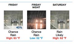
We were going to do it tomorrow, but as the week went on the weather forecast got more and more certain that it was going to dump down rain all weekend, while clearing up and getting really cold next weekend, so we decided that freezing our appendages off was a safer bet than getting soaked. I’m not sure how my feet will feel about this (I only have one pair of shoes that are cleatable, and they’re more summer shoes than cold weather shoes. I do have a pair of toe covers somewhere, so I guess I’ll need to go and find them) but there’s only one way to find out. This weekend, when it’s raining, we’ll just do something sedate like one of my alpine 300s, where at least if we get soaked to the skin we’ll get soaked to the skin within 90 miles of Portland.
If I finish this one without dying, it will put me at ~9900 miles and ~9400 RUSA km for the year (100 miles in 75 days? Oh, I think I can do that. Ditto for 600km – Ripplebrook and Silver Falls are not that far away, and if the mountain passes haven’t snowed in there might be enough time for a 300 or 400 as well. But I will first ensure that I don’t die this weekend.)
—orc Thu Oct 11 10:03:34 2012
Oct 06, 2012
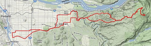
I can’t believe that this isn’t already registered as a RUSA permanent populaire, but when I browsed the list of Oregon permanent it didn’t show up. It’s really a simple outandback, with a few route tweaks for variety, and one substantial climb in the middle.
Larch Mountain is, at least when it’s not snowed in, a popular climb for fit road cyclists. The climb (~3900 feet from the Sandy River) is quite nice, climbing first through fields and villages, then up and through the Mount Hood National Forest and along the edge of the Portland watershed to a summit parking lot ~80 feet below the actual summit. It’s a pretty relentless climb; after you clear the lower plateau (where Springdale & Corbett sit) it goes up without a break basically all the way to the summit.
But first you’ve got to get there. This loop starts, as is traditional, at Bybee & Milwaukie (Marsee Baking is here, as is a Starbucks, a handful of restaurants and bars, and Staccato Gelato) and goes directly east on Bybee Blvd, which twists around the Eastmoreland golf course and becomes Woodstock before heading east towards i205. You take Woodstock for a considerable distance, but not all the way to i205 (where it merges, in a horrible mass of on and off lanes, with Foster Road) but only to 97th Ave, which has a bicycle/ped light where it crosses Foster.
Once cross Foster, the route works east on sidestreets for a while before it drops you onto the Springwater Trail for a 4 mile run out into Gresham, where you get back onto city streets to go north to Stark St, which you again take east to the Sandy River gorge and the start of the big climb. (Made a little bigger by, after you climb up to Springdale, being routed onto Hurlbert Road, and then Louden Road, which gets around the climb through Corbett by being an far steeper connection to upper Larch Mountain Road.)
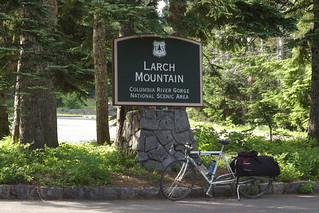
And then all you need to do is climb up to the summit and you’re more or less done with the climbing on this route.
The return is, obviously, on Larch Mountain Road (there are other roads coming off Larch Mountain Road, but they all go into the Portland watershed and are off-limit to non-permitted users because this is where Portland’s water supply comes from) but it doesn’t diverge back onto Louden Road, but takes Larch Mountain Road all the way down to the Historic Columbia River Highway, and takes that (with one shortcut on Bell Road, which is really steep and fast, but doesn’t have the best pavement; if you’re not confident in your abilities to handle steep potholed roads, staying on the Historic Columbia River Highway gets you to the exact same place as Bell Road does at the cost of maybe ½ kilometer) all the way down to the Sandy River gorge and, eventually, Troutdale.
In Troutdale, the Historic Columbia River Highway becomes Halsey Blvd, but you’re not going that way; there’s one more climb up 257th Ave into Gresham, where, after some wandering around on city streets, you eventually reach the Gresham-Fairview Trail, which you take south back to the Springwater Trail, then west on it all the way into Sellwood, where there’s a last mile of city street to return you to Milwaukie & Bybee.
Note that Larch Mountain Road closes during the winter, and is out of service from roughly November to June. So this is a summer/fall ride only (and I hope it gets approved soon so I can checkride it before the fall rains/snow starts … I’m not holding my breath, given that the long term weather forecast is showing “chance of rain” for what I hope will be next weekend’s 700, but it would be nice.)
—orc Sat Oct 6 17:53:25 2012
It’s October 6th, and I’ve got 86 days left in the year to get myself to 10k miles (760 to go) and 1 RUSA megameter (1397km to go) and I suddenly find that a ride I’d arranged for Sunday has fallen through.
So opportunities abound. Should I
Ride, for the third time, the High Rock 300 and see if I can better the 14h58 I did on the first loop? My iphone, if I put it into airplane mode as soon as I reach Faraday Road, has about 25 hours before it runs out of juice, so I can plug in one earphone and music my way up to Ripplebrook and around Timothy Lake.
Ride, for the first time this year, Sellwood to Hood & Back. If I ride this one, it will give me a chance to verify the info controls out on the mountain (I know that I need to refresh the Clackamas Lake Ranger Station one for certain), and it will get my feet on every permanent I own at least once this year. But it’s got a bucketload of climbing (the last time I rode it it took me exactly 17 hours to complete the loop. Admittedly, this was without riding about 6000 miles in the four months preceding the loop, so I could probably carve off some time) and a really really cold descent down highway 26 from Government Camp to Zigzag, so I’d pretty much have to start at 5am Sunday morning to get back by 10pm and have even the slightest chance of being functional on Monday.
Bail on a 300 this week (I’m hoping to be able to ride a 700 next weekend, so it’s not as if I’m waving goodbye to my last chance of riding a long loop until next June) and just attempt to ride a fast 200 (either to Ripplebrook or Silver Falls) with the aim of getting myself down to or under a 8 hour loop time.
Sellwood to Hood & Back is the most problematic to do by myself, because of the teeny detail of about 10k feet of climbing and no services between mp 59 and 124. That, combined with the other teeny detail of having no cell phone coverage from mp 35 to mp 110, makes for a long desolate ride in the alpine wilderness late in the season, which, although it might be early for snap blizzards, is still a long ways out in a part of the world where the weather can be unpredictable.
The High Rock 300k is more doable, and I could probably get back home before 9pm. But that’s still pretty late for the day before school. If I bailed and did a fast 200, I could leave home at 6am and maybe be home again at 2pm, then fill in with a populaire immediately afterwards or on Monday morning.
A 300 would give me 8904 RUSA km, a 200 would give me 8803/8806 (Silver Falls/Ripplebrook) and get me back early enough so I could maybe clock in another run up to Sandy on Monday morning, which would leave me with 8907/8911 km, which combined with a midweek populaire and the (I certainly hope it’s approved this weekend/early next week!) 700 to get me up to 9730km (and 10k/10k/perm-SR by the end of the following weekend.)
And a 200 would be less exhausting if I’ve actually got a cold instead of being socked with a round of allergies. Go for the glory, or be cautious and maximize the chances of getting my permanent-SR for the year?
Decisions, decisions.
—orc Sat Oct 6 00:34:39 2012
Oct 05, 2012
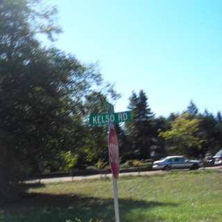
My plan for this morning was to make a quick run up to Sandy on Kevin Brightbill’s Nicolas Flamel populaire before going over to Llewellyn to retrieve Silas, but a few things got in my way.
First, I was an absolute slug this morning and didn’t get myself out the door until about 9:45 (and this after discovering the rear tire on the mlcm had gone flat in the three days since my last populaire – I pumped it up and hoped that it was not a puncture, but, alas, this was not to be the case…)
Secondly, when I got four miles north of home, I needed to stop and find the pokey thing that had put a hole in my rear tire, because the pumped up tire had lost most of its air by then. The tread on the rear Nomad is getting worn down a bit after 1400 miles, but that’s not where the puncturing object was; no, there was a piece of glass driven sideways into the tire about half a cm away from the centerline, and it had been driven, possibly during the last populaire, just far enough to put a teeny little puncture into the tire.
I pulled the piece of glass out, repaired the tire in place, and, miraculously, it stayed patched and didn’t force me to do the 35 minute marathon tube repair/replace/repair/curse session I did when the bicycle tried to eat a cotter bolt.
Thirdly, and most importantly, after I transited NE Portland (overhauling Natalie Ramsland and her tiny baby™ as she rowed her narrow-tired drop-barred (and with saddle to bar drop like G-d Himself Intended) xtracycle up the ramp on 15th just south of Prescott Street. I recognized her from the Sweetpea website (as well I should, because I’ve been sadly admiring her framebuilding for several years now, both from pictures on the website and from the Sweetpea frames that four of my friends/acquaintances own. Man, if I had $3000 burning a hole in my pocket I’d be frantically trying to get onto her waitlist to build me a road-geometry longtail to replace the trek with (and then put a low-trail fork and 650b wheels under the Trek 400 frame, just so I could have a machine to compare low trail 650b vs 700c with a wide variety of tires instead of the limited set I experimented with the last time around) but I noticed the geometry and wheelset of the bicycle (650a wheels? 26" wheels? In any case, the tires were much narrower than the nicely painted prismatic fenders on the thing, and they certainly looked narrower than the 28mm Nomads on the mlcm) well before that) I was thwarted by a nasty gusty east wind that pushed me back all the way up Marine Drive and most of the way up Bluff Road. I tried to do my usual put my head down and ram through the wind, but, lord, the headlong gusts of wind just killed my forward momentum and made it really hard to keep above 13mph.
In any case, the trip up was slow enough so I reached the southern border of Sandy (at the junction of Bluff Road and Kelso Road) at 12:40, which left me 90 minutes to get back home, switch bicycles, load the bear-fetching bicycle with snacks, and get the half mile over to Llewellyn before people panicked. I can do that without too much trouble when there’s a tailwind (fortunately the east wind was showing no signs of turning around when I got there) but if I’d taken the additional 20 minutes to go the 2 miles up (another 200 feet of climbing, all into headwinds) to Joe’s Donuts and 2 miles back that would leave me with 60 minutes to go 24 miles.
Drat.
So I DNFed on the spot, turned west, and sprinted towards home (along, may I add, the return route for the populaire – there’s an info control in Gresham to stop people from short-circuiting the route along 212 or Sunshine Valley Road, but there’s much more climbing there which makes those two alternatives slower than just taking the Springwater Trail – arriving home (after stopping to retrieve a dollars worth of change when I reached CSellwood) 85 minutes after I abandoned (I’m not sure if this is my fastest return – I managed to burn down the hill pretty quickly a few times last year on the xtracycle – but it certainly had some of the fastest segment speeds I’ve done (averaging 30mph on Kelso road, averaging about 18mph for the rest of the run into Portland, and only losing speed when waiting for stoplights and cross traffic at grade crossings,) which gave me a whopping 10 minutes to get everything ready and get over to Llewellyn. So I put on some +4s over the tights I was wearing, so I wouldn’t look quite so bike-geeky.
The truncated loop was still pretty slow; 4h23 to go 60.25 miles (4h05 moving time; the tube repair was not as much of a timesink as it usually is) so I’ll have to try it again in the next few days to see if I can get myself under that 4 hour bar.
Not very many pictures today because once I reached Marine Drive I was too busy cursing my way along against the headwind, and then when I was coming back I was too busy sprinting along as fast as I could go to even slow down and take photographs en passant.
Oh well, there’s always another day.
—orc Fri Oct 5 23:19:14 2012
Oct 04, 2012
I’ve found a small problem with my “ride the eff out of my bicycle” policy this summer, and it’s not the normal collection of things that can happen when I’m hammering my head against the well of exercising too much (though I did develop some really interesting blisters at the base of my hands, which ended up with me getting a pair of unpadded cycling gloves to try and work around; if they don’t work, I’ll just stock up on moleskin bandages and apply chunks of it before each ride) but it’s that if I forget to write up the ride in question (because of either being burned out, exhausted, or staggering along on the edge of a nervous breakdown as I juggle several projects + babyherding) right after doing it another one comes along and needs to be written up as well.
So, after a mere two weeks I’m backlogged by, um, six permanents.
So I’ll do executive summaries of them all.
On the 20th of last month, Kevin Brightbill and I (we’re dragging each other along in an attempt to get up to 10k RUSA kilometers for the year) rode his Nicolas Flamel populaire up to Sandy and back. Joe’s Donuts has ceased to be as much of a time sink as it traditionally has been, cuz vegan, but we still felt like we were creeping along the loop (it was an unusually sunny day, with only a slight wind, so we didn’t get the feeling of being blown along the road that we have been getting) and were pleasantly surprised to finish up in 4h22. Not very many pictures, though, because the only camera I brought along was the iphone, and there’s no way I’m going to take it out and try to take pictures at speed, because if I lost my grip on it the results would be unpleasant. One of these days I need to get a phone case that gives me a better grip, but that day is not today.
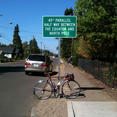
On Saturday the 22nd, Kevin and I decided to ride down to Silver Falls on my One Big Hill permanent, with a couple of moderate reroutings that I wanted to check out. This was another slow day, but slow now means between 9 and 10 hours. We discovered, to our annoyance, that there are some new rangers at Silver Falls who are running around saying that not only can’t people ride their bicycles by the South Lodge (a reasonable demand, given the amount of pedestrian traffic) but people can’t even walk their bicycles up to the Lodge, but instead need to stash them in a flimsy wooden wheelbreaker rack.
Sorry, that’s not going to happen; if my bicycle got stolen or had the wheel folded, I’d be stuck 60 miles from home without any way to even call for help, because Silver Falls is a long ways away from any t-mobile cell tower. So this permanent is going to need to be rearranged to avoid the South Falls lodge, and I’m going to have to find some way to make up the missing mile elsewhere.
And the rerouting? The return route normally goes from Mount Angel over to Meridian Road via Marquam Road, but if you continue east instead of turning onto Meridian you eventually (in a mile or so) reach Farm Road, which takes you north to Needy Road,, which rollers enthusiastically all the way up to where it rejoins the published route at Zimmerman. It’s a far more orrando-friendly route than Meridian and Barlow (almost no traffic and long stretches of terrible pavement) which is, as far as my odometer can tell, exactly the same distance as going up Meridian.
More pictures here, because I remembered to bring the camera.
After riding down to Silver Falls on the 22nd, I wanted to go out for a quick ride on the morning of the 23rd to keep my legs from freezing up on me. So I planned on a quick morning trip up to Sandy. Or what would have been a quick morning trip except that I went through a drift of gravel that contained a cotter pin, which went right through my rear tire and gave me the opportunity to cool my heels for about 40 minute while I patched the tire, discovered that I missed the second hole where the cotter pin went in, and swapped out for a second tire, which, thankfully did not have any surprise holes in it.
I wanted to do the loop in < 4 hours, but it took 5h23. Oh well. And there weren’t very many pictures either, due to the run to Sandy being one that I’ve done approximately 100 times in the past 4 years.
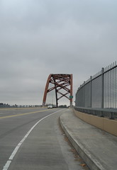
The following Wednesday (the 26th) I decided that I’d make another run at Sauvie Island and see if I could get under 4 hours for that 110km loop. Sadly, no, this was not going to happen; it was a more traditionally cold cloudy September morn, and that took a lot of the bounce out of my step and made the run up to Sauvie Island and the two runs north (against a nice cold headwind) seem like they took forever.
To my surprise, “forever” was 4h11, which was only 7 minutes slower than my fastest run on this loop. Proof that I’m getting faster.
Once again there weren’t that many pictures of the loop, because I was too busy being cold to remember to photograph the atrocities.
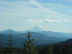
On the last Saturday of the month, Michael Powell Parich and I took another run at my High Rock 300, trying to see if we could do better than my solo 14h58. The quick answer to this was “no” – despite not having to make repeated stops to check cues and mark down info control questions it still took us 15h50, mainly because of a series of hardware failures (Michael’s Paramount ate a metal screw on 224 opposite Promentary Park, and the new tube had a pinhole in it that took the wheel down to flat on NF 46 about 4 miles this side of the junction with NF 42. It took quite a while to repair the second one, because when we patched the first tube again the patch blew off when the tube as inflated, and then I had to spend a considerable amount of time hunting down the pinhole on the second tube. And then, to add insult to injury, the brake bridge fender mount on the mlcm started working loose as we descended Peavine Mountain towards Clackamas Lake, so we had to stop and retighten it before continuing.
A few more pictures because I’ve not ridden this loop enough times to become jaded about it :-)
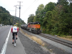
And then we come to October, where the first ride was another run up to Sauvie Island. This was a traditionally nasty October morn; no rain, but it was cold, cloudy, and there was a savage north wind blowing. Kevin rode with me this time, and we exchanged pulls all the way north. Alas, my tendency to put my head down and ride as fast as I can into headwinds didn’t work very well this day, because every time I got in the lead I stomped on the gas, charged north at 20+ mph, then realized that Kevin had fallen a long way behind me so I had to slow way down for him to catch up. After a while of this, I decided it was probably the better part of valour to just follow him except in particularly nasty headwindish spots where me pulling made the difference between 16mph and 12mph.
It was really cold up until we reached the nude beach on the northeast corner of Sauvie Island, and then the clouds broke up and it was a lovely warm(ish) tailwindy day all the way back into town, which had the undesirable effect of making us a little slower with the tailwind than we were with the headwinds. 4h22, which isn’t a record breaker, but which also isn’t bad.
I took pictures of locomotives, trolleys, and Roxy, but not so many pictures of the scenery here :-)
And, after all this, I had my RUSA kilometerage up to 8603 (868 miles to a megameter) and my yearly milage up to 9200. I’ll break 10k miles before I break 10 megameters, but it’ll be close either way. Maybe I’ll get there by the middle of this month?
—orc Thu Oct 4 21:10:09 2012
Oct 03, 2012
Yup, it’s still sunny and warm(ish).
During the day.
At night it’s not warm. It’s not freezing (mainly; sheltered pockets get really cold at night, and I was noticing this in August, and it’s two months later now) but it’s now at the time of the year where I have to, when I go out for a reasonably long bike ride, dress for both freezing cold and somewhat warm weather.
And the days are getting short; when I go out for a 300k, I leave when it’s dark and return when it’s dark (it doesn’t help that my 300k permanents all go up into the mountains. I could probably do them in daylight if I managed to stay on the Willamette valley floor.) So, sadly, it looks like riding anything longer than 200k will be grinding to a stop after the next couple of weeks (this upcoming Sunday I’m riding a 300k – I’d made tentative plans to ride it with a friend, but I’m riding it even if those plans fall through because I’d hate to waste an unseasonably sunny day – and the weekend after that, depending on if the permanent is approved, I’m going to be riding a 700k to finish up my permanent-SR for the year) and I’ll be stuck riding a combination of 200s and 100s until the year staggers to an end and I make the appointment for shoulder repair surgery (which will take me out of service for 3-6 months unless I can get a Tadpole trike for physical therapy purposes, and even if I do get a Tadpole it’s not going to be what I would call the most inspired bike riding, given that the whole “out of service for 3-6 months” includes not using my right arm for anything during that time. So, actually, the 3-6 months is likely to be closer to a year, given that if I don’t use my right arm for 3-6 months it will atrophy down to a twig and I’ll have to slowly build it back up to a level of fitness where I can actually use it when I’m riding my bicycle.)
But, on the bright side, I may not have to worry about looking around for waterproof bicycle shoes for the rainy season, and that will defer spending $middle-three-digits for a while. Oh the joy.
—orc Wed Oct 3 22:56:35 2012
Oct 01, 2012
Blue/Red sails north on Grand Avenue at around 6:20 tonight.
—orc Mon Oct 1 22:06:57 2012
—30—