Permanent 1697 – Estacada 100 – 103 km
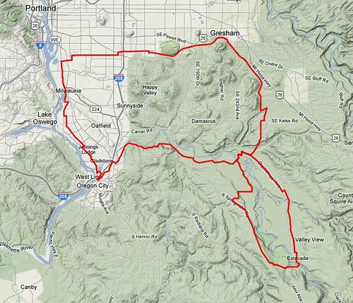
This is my idea of a flat loop. There are only three steep ramps on it (Woodstock just east of Chavez in Portland, Eaden Road just before climbing up to Springwater Road and the Broadway cliff in Estacada) and the rest of it is either flat or fairly gradually graded. It starts out, as is traditional, at Milwaukie and Bybee, but instead of going south it goes directly east on Bybee, around the Eastmoreland golf course on 28th, then east again on Woodstock out as far as 87th, where it zigs north onto quieter city streets for the last couple of miles out to a connection with the Springwater Trail.
The Springwater Trail takes you east through Gresham, then south into Boring (the paved part of the trail ends at the Multnomah County line; you can continue into Boring along the unimproved railbed, but the cuesheet directs you onto adjacent roads) where the first control sits. And after the first control, it follows (the all too familiar if you ride a lot of my permanents route on) Ritchey, Kelso, and Amisigger Road down into the Clackamas River Valley, and then dumps you onto OR-224 for a mile and change until you reach the town of Barton, where you abandon the highway for Baker’s Ferry Road, and then, almost immediately after crossing the Clackamas, you abandon Baker’s Ferry Road for Eaden Road, which is a nice quiet loop along the lower bluff top by the Clackamas River, with only one honkingly steep ramp where it climbs up to the upper bluff where Springwater Road runs.
Springwater Road takes you south again, climbing slowly, up until you’re parallel to Milo McIver Park, where you turn off onto Hayden Road and then plummet about 700 feet back down to the Clackamas River and the next control in Estacada. If you’re not in a hurry, there are some nice brewpubs, coffeeshops, and restaurants here (and why be in a hurry? The climbing is pretty much all done now and all you’ll see, after you winch your way up the Broadway cliff, is rollers and river crossings.)
The route back from Estacada attempts to avoid Highway 224 as much as possible by taking Eagle Creek Road instead. There’s a pretty steep ramp in Estacada (Broadway attempts to go directly up the bluff from lower Estacada to upper Estacada) that may see you dropping into your alpine gears, but once you’re up there it’s generally downhill, with a few rollers, all the way to where you have to leave Eagle Creek Road and get back to OR-224 so you can run up into Barton (and then across the Clackamas on Baker’s Ferry Road) for the second time in the day.
But this time you’re not going on Eaden Road. No, you climb up to the top of the lower bluff, and then scoot along the edge of it back to Springwater Road, which you take north and west into the little town of Carver, where you join Clackamas River Road for a pleasant, if somewhat trafficky, section that runs through farmlands, then alongside the Clackamas, and then through suburban estates until you climb a short ramp, pass a water facility, and are popped right into Oregon City proper.
The state of Oregon has just finished spending a large sum of money to redesign the highway intersection here to make it easier for Clackamas County commuters to get up into Portland, but one of the side effects of this is that what used to be a grade crossing of Highway 213 is now an underpass, so now Clackamas River Road runs into a roundabout, and when it comes out it’s Oregon City’s Washington Street. There is a bike lane here, but it’s not particularly good (the road surface is pretty terrible, and there are drifts of tire-puncturing debris scattered here and there along it. Ask me how I know about that!) so you might want to ride, cautiously, in the traffic lane until you reach the open control around 15th St, where you leave Washington and connect to Main St and the north.
Normally I route people on Main Street to an access road for the Oregon City Shopping Center, and from there onto 99E up to River Road (the less-trafficked way into Portland) but there’s a better way to get there; there’s a MUP that connects Main Street from the old stub of Washington Street (Washington Street used to, before the interstate highway severed it, connect to a bridge into Gladstone. That bridge has been abandoned to auto traffic and is now only used as a ped/bike bridge, and it gets you across the river and onto Arlington Ave (which turns into River Road at 99E) and keeps you from having to do a left turn across a major highway.
You take River Road for a mile or so north, but then jog to the right and onto the newly opened Trolley Trail (another abandoned Portland Traction ROW, just like the Springwater Trail) which goes in a much more evenly graded manner all the way into downtown Milwaukie. Or at least it will go all the way into Milwaukie when the last mile is finished, but for now, after a few evenly graded miles on the Trolley Trail you jog back to the left onto River Road, then plunge down off the point of land south of downtown Milwaukie in a much more precipitous manner.
And once you’re in Milwaukie, you’re just about done. It’s about 3 miles up to Milwaukie and Bybee again, and it’s just one road (17th Ave, which becomes Milwaukie Ave about a mile into Portland) all the way there.
(Once it’s approved, I’ll publish a copy of the cue sheet. But for now you can look at the prototype map on bikeroutetoaster.)