Permanent 1566 – One Big Hill & Silver Falls – 200 km
A couple of months ago, I rode orrando’s spring 200 which, in between bouts of rain and runs up the Molalla River to an info control out in the middle of nowhere, went south for a loop through Silver Falls State Park. It was a lovely ride (even including the rain, but not including the front shifter which wasn’t actually shifting that day) only slightly spoiled by the tiny detail that it started 18 miles away from home.
So, after the brevet was over, I started mulling over ways to get the most scenic parts of the ride (I’m sure the Molalla River branch is scenic, but it was raining and I was to busy being dropped and/or chasing after people) into a nice loop out of Portland, and eventually came up with this loop.
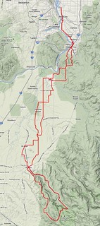
It starts, as is traditional, in Sellwood (nice and close to my house) and proceeds south through Milwaukie (etc) down to Oregon City, where you climb up onto the Boring Lava, then drop out of the urban growth boundary (and back to river level) for a long haul through farmland south. On the way down, it loops into Canby for the traditional stop at Cutsforth’s Thriftway, then proceeds on to Barlow Road for 20 miles of wandering south through gently rolling farmlands down to Silverton.
In Silverton, you can stop for a snack if you want, or you can just continue onwards. But it stops being flat here and becomes one big hill; halfway through Silverton, the road turns up and climbs, in two big steps, 1700 feet up to the entrance of Silver Falls State Park.
The hidden control at Silver Falls State Park is the south lodge, which is conveniently located out of sight and behind a confusing direction sign, about 1000 feet along a no bike-riding allowed gravel path. If it’s a cold day, they’ll have a fire here, and in any case there’s a little concession stand inside the lodge so you can get a little something (and a receipt) and stretch your feet for a while before it’s time to come back home.
There are a lot of waterfalls in Silver Falls State Park. Not many of them are visible from the highway, but South Falls is not too far away from the lodge so you can walk over and see it before you go, and North Falls is located where the highway loops around and turns back north (there is a scenic overlook just before this point – the last time I went through I didn’t stop for a photo, but there’s no reason why you shouldn’t stop.)
You climb a bit from the lodge up to North Falls, then you bounce in and out of small valleys for a few miles, but after that it’s time to return to river level, and the highway does that enthusiastically – it descends long a series of long tangents, then sinuously wiggles down the side of a ridgeline and deposits you at the west end of Silverton again.
On the other side of Silverton, it’s only about 15 miles to Mount Angel and the last transit control of the loop. It’s not easy to keep of the main highways, but the route tries its best to do so, wandering along side roads (and through a covered bridge) until it deposits you onto Mount Angel Highway for the last two miles into Mount Angel itself.
And then its back into the countryside. The route wanders northeast for a few miles, then drops you onto Meridian Road for a fast run up to the neighborhood of Canby, where you come into the city to within 5 blocks of your outbound route before it turns back east and climbs up onto the Boring Lava for a series of annoyingly steep, but thankfully short, ramps, that deliver you back into Oregon City, where you (eventually) rejoin River Road for the run back up into Sellwood.
A cuesheet is available here, and if you want to ride this for RUSA credit contact me at orc@pell.portland.or.us.