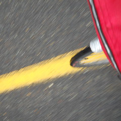
It’s raining, so it must be Orrando brevet season
This year, Oregon Randonneurs is running two rando series; a summer series based in Portland, and the regular spring series that’s not based in Portland.
The existance of the Portland series has made it possible to push the spring series out further into the countryside, reusing old routes that have lain dormant for a couple of years and creating new routes that start a long ways away from Portland.
The spring 200k was one of the new ones. It’s a Michael Wolfe route, which pretty much guarantees a lot of steep climbing, and also guarantees that my only personal best would be to actually complete it instead of DNFing out on top of some mountain.
And it starts/finishes in Canby, which is 18 miles away from my front door.
Ugh.
Sometime last week, before I’d even made the leap from signing up for the loop to figuring out how I would actually get there to ride it, my friend Theo sent out mail to a bunch of the Portland crew mentioning that he was planning on riding down there and maybe we should do it en masse.
A few exchanges of mail later, it ended up being that me, Theo, and our friend Asta would be riding down with maybe a couple of other people doing it as well. So at 4am on Saturday morning, I woke up, took a quick shower, ate a bowl of cereal, then went outside to meet them at a little bit after 5am. They were running a bit late, so I took the opportunity to ride the mlcm up and down the block to test for rattles and fix them. And then Theo & Asta arrived and we shot off towards Canby via River Road (where I discovered that I must have knocked my pusher out of alignment by the simple expedient of having the thing derail my chain into the bottom bracket when I shifted to the alpine ring), then 99e from Oregon City south.
When I got up at 4am, it was drizzling, but it had stoppped by 5am and there was actually clear sky visible. This did not last, and we arrived in Canby just as the clouds opened up and started dumping down rain. And this rain was still coming down when 7am rolled around and we were shooed away into the deluge.
Most of my Portland friends are quite fast (and all of my Portland friends who showed up for this ride are in the quite fast category,) so if I wanted to ride with them at all I needed to be quite fast as well. And I managed to do this by religiously following Theo and Asta off the line and sailing along with the fast guys down the road as far as the Molalla River, where the route curved abruptly south and up a longish steep ramp.
At which point I attempted to shift into my alpine ring and it didn’t work. It didn’t derail, but it didn’t shift, and trying to push 240 pounds of bicycle and Orc up an 11% ramp in 50×24 (I have an 11-28 cassette, but get huge chainrub in 50×28) doesn’t actually work very well. So I stopped to hand-shift and all the people I was riding with simply evaporated into the morning rain.
Okay. So I hand-shifted and ground off after them. I saw a couple of the tail end of the fast guys in the distance for a while, but by the time I passed the Dickey Prairie store I was riding by myself, and didn’t see any other riders for a considerable period of time. (A not particularly happy situation, this was an outandback up into the headwaters of the Molalla River and the cues were somewhat iffy; you go upgrade on Dickey Prairie road for a while, then cut over the river and go up Molalla Forest Road for a long while, but there’s a nice wye connecting the Molalla Forest Road to the Dickey Prairie connector stub that’s not signaled and I ended up riding a little way the wrong way before remembering that I needed to be going upgrade into the mountains.)
So up I went, seeing nobody except a couple of riders who passed me on steeper sections of grade, until about a mile and a half from the top control where the fast guys came screaming downgrade (the lead pack, including Theo, were about 12 minutes up on me, then another pack was about 8 minutes up, and then a few single riders came past until I rode into the control just as Asta and Steven Casper were pulling out.)
I wasn’t particularly interested in riding alone if I could help it, so as soon as I got my card signed I waved goodbye to the control, lit off my afterburners, and sprinted back down the mountain trying to catch up to any of my friends.
I was fairly lucky this time; I managed to overhaul Asta just before I ran out of energy and blew up, and was able to reduce to a fast but still sensible speed and ride with her the rest of the way down the mountain towards Molalla. And we basically stuck together for the rest of the loop, which was fortunate because the both of us had a devil of a time following some of the cues and would have gotten horribly lost one way or another without having the other say “whoops, we’re going the wrong way” after yet another misstep.
We’d been maintaining a brevet average of 15mph up until Molalla, but that plan went right out the window when we had the choice between either warming up or bolting onwards and blowing up. So we stopped for a considerable period of time at a gas station/minimart on OR 211, and then (after a festival of misreading cues) proceeded south towards Silverton.
It had stopped raining about the time we reached the Molalla control, so that meant I could actually start to enjoy the ride (or at least the parts that weren’t climbing – the climby parts involved me going as fast as I could so I wouldn’t lose sight of Asta, and then making up for the lost distance by sprinting ahead to catch up to her.) The route went through a really hilly section south of Molalla, but it was a fairly farmy hilly area, and we spent most of it going past various horse, cattle, and llama/alpaca ranches, with the occasional crop field thrown in. And then we plunged back down to the valley and headed over to Meridian Road for a quick ride south into Silverton (with yet another miscue that threw us a long ways off the route before we corrected and got back to where we needed to be :-()
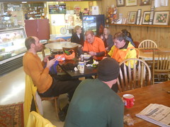
And in Silverton? It was lunchtime, so we stopped for food and coffee before starting the climb up to Silver Falls State Park. And then we missed the turn for the climb and ended up riding past the Oregon Garden before realizing our mistake and going back. And then we settled in for a nice loooooooong climb from ~250 feet asl to ~1750 feet asl.
One good thing is that the clouds had broken up and it had become a nice sunny day. But this was compensated for by a stiff south wind, which was either a headwind or a savage crosswind (savage enough to blow open my porteur-randonneur bag and whisk my cuesheet away, so I had to stop and run across a field to recover it) for the bulk of the climb (the non-windy part of the climb was a 3 mile 900 foot climb to the entrance of Silver Falls State Park, which featured a brief hailstorm as I crawled, cursing, up the ramp while Asta vanished into the distance, not to be seen again until I sailed into the south falls/park lodge parking lot where she had paused to demolish some of her collection of rando fud.)
We found the lodge (not an easy task if you’ve never been there before; the signage is not intuitive) and parked ourselves there for about 45 minutes to warm up (there was a lovely fire going inside the lodge), get more water, use the bathrooms, and relayer for the descent. Alas, I did not get any photos here because I was too busy being fried from the climb.
And then all we had to do was get back to Canby. This involves riding around the waterfalls on OR214, then plunging down the mountain into Silverton, and then riding north (with the wind at our back) up Meridian, et seq, to Canby.
The descent is pretty nice. You climb up about 300 feet from the south falls to a bridge just southeast of the north falls, then climb in and out of half a dozen shallow ravines, then tip over the edge of the hill and fall down into the valley, first along a series of long tangents and then along a sinuously wiggling road (but not tightly wiggling) that carves down the side of a ridgeline. If you’re used to descending, you can do this without brakes, and it almost makes for the pain of climbing all the way up that mountainside.
When we reached Silverton, we stripped off most of our layers, then bolted north, with the wind at our back, to finish the last 22 miles of the loop. Asta was flying along here, so I followed along as fast as I could go and managed to just barely hang on as we shot north through fields, farms, and small villages, arriving in Canby just as the evening Cascades went zipping through towards Salem and points south.
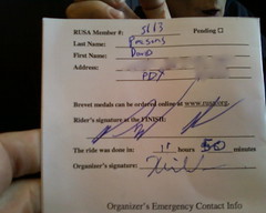
Not a very fast loop, I’m afraid, but we finished before the sun went down and before the evening rainstorms started. And then, after a considerable time spent sitting in the restaurant that was the closing control, we were rescued by Oliver Smith and given a ride back into town instead of having to ride, through the pouring rain, that last 18 miles back to civilization.
And then I had to spend six hours cleaning for Silas’s 10th birthday party.
Pictures? Yes, right here. Sanity? Nope, not at all, and that’s the way I like it.
Comments
No, I actually enjoyed most of the loop. The unsigned wye onto Molalla Forest Road was annoying (it is not an obvious left turn there,) the south end of Meridian really wants to turn you onto Hobart, and the location of the south falls lodge is very unintuitive, but other than that (and the last 500 feet up to the summit in Silver Falls park, which has wonderful sightlines so I can see exactly how hard I’m being dropped on it :-( ) it’s a nice day out on the line and I’ve added some of the bits of it to my collection of roads to add into permanents.
Getting soaked by the morning rain didn’t help with the cuesheet reading very much (Molalla was a festival of misdirection, and we probably ate about 10 minutes each doing a wrong turn and being corrected by the other) but that’s not an artifact of the route.
Comments are closed
You know, from reading this, I don’t get the idea that you enjoyed the ride very much. Sorry if that’s the case. Also, my reputation for including arduous climbs is probably well deserved, but it’s funny to read it since I’d say you’re probably most acquainted with my UGB route, which isn’t particularly thick with steep ramps.