Facing my demons
My first encounter with Slab Creek Road was a couple of years ago when I was plotting the route of the Oregon Coast 600k and followed it off 101 and up the mountain. For some reason I didn’t realize that this mountain was connected to Cascade Head, and thought that it was a bizarre climb that was put in just to torment the riders. I didn’t ride the Oregon Coast 600k that year, but the following year I did actually ride it, and when I rode up Slab Creek Road (in the dark, in the rain, following my friends Theo & Asta and being acutely miserable because I was climbing slowly even for me) it seemed like a nightmarishly steep potholed mess leading to an info control that was difficult to even see, let alone answer. And this spring, when I DNF'ed the spring 600k, the existence of Slab Creek Road was a small, but noticeable, part of why I bailed at Summit.
So when I found myself in Pacific City this week, I pretty much had to ride down there and see if my nightmarish memories of the road were at all accurate.
I’d ridden up on Monday, so I couldn’t do it then. I spent Tuesday (my birthday) being a sea slug and didn’t get out on the bicycle until about 4pm, so only had time to explore the southern end of Sandlake Road (a nicer way to get into Pacific City at night than the route that wraps around the nose of Cape Kiwanda, but it’s a nicer route with no shoulders and it’s a bit longer, so I can see why none of the brevets around here use it,) so decided last night that I would go out this morning and climb it once or twice (actually twice or 4 times, because once I transited Slab Creek Road, I’d need to transit it again to return to Pacific City) to see if my memories were at all accurate.
So at ~9am this morning (after a couple of hours of slowly getting ready to go) I hopped on the mlcm and headed out.
The cottage we’re staying (one of Julie’s college friends won a weeks vacation here, and invited our family along for the week) is in Pacific City Heights, which is up on top of the hill that pinches the southern end of Pacific City against the Nestucca River) is approximately 200 feet up from the ocean, so all of the riding I’ve been doing here involves a precipitious descent right off the bat, starting with a block of steep rutted gravel. So I was pretty awake by the time I got down to sea level and worked my way out to highway 101 (not via the traditional Orrando Brooten Road segment, but via a little farm road that runs along the other side of the hill that Pacific City Heights is on) and then pointed south for the 9 mile run down to my destiny.
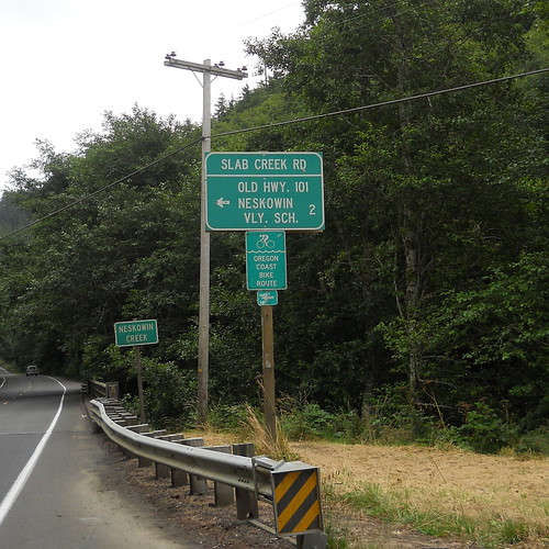
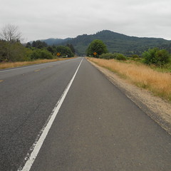
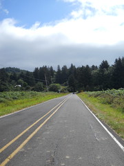
The run down to Slab Creek Road is about as uneventful as highway 101 can be; a couple of miles across the wetlands around Nestucca Bay, a gradual climb over a few small hills, then dropping down to go just east of Neskowin, then the road tips up slightly and starts to work its way up to Cascade Head, and then, just about 500 feet before 101 tilts severely up, there’s the exit for Slab Creek Road, aka Old Highway 101.
So I girded my loins, then turned off to the east and prepared to make the attack on Slab Creek Road. But no sooner than I finished the turn than I saw a construction sign informing me that Slab Creek Road was closed 4 miles up, and a hastily handwritten postscript mention that it was closed to bicycles and pedestrians as well.
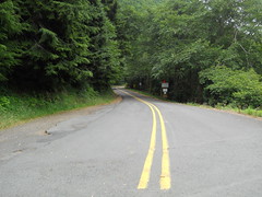
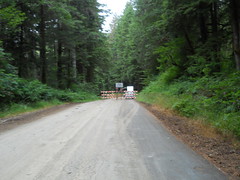
Huh. well, I’ll have to see about that. On went the earphones, on went Crush Therapy, and off I went towards the oppressively steep and sketchy climb over Cascade Head. Oddly, it didn’t seem that steep today (I was chugging along in my big ring, and never felt that I was pushing to stay out of the alpine ring) and what was better is that some large stretches of the road had nice new smooth pavement at about the places where I remember attempting to dodge back and forth in the rain to avoid the potholes without also bodychecking Theo and/or Asta off the road into the canyon. And before I knew it, I was in the Siuslaw National Forest and coming up on a fairly substantial barrier marked ROAD CLOSED. So of course I had to go around it and see just how severely it was closed…
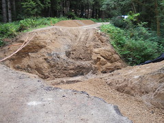
Well, no point in trying to cross here. I guess I’d just have to get to the other side of the road the old fashioned way – go back to highway 101, climb Cascade Head, then take NF 12 up to the other end of the washout. So that’s what I did.
The climb up Cascade Head on highway 101 is much more severe than Slab Creek Road is. The road pitches up about 500 feet past the Slab Creek Road exit, then climbs 700 feet without relenting in approximately 2 miles. A 6% grade isn’t that horrible compared to some of the stupidly steep ramps found elsewhere in Oregon, but it’s traditionally been enough to make me drop down to my dump gear and turtle up the hill at about 4 mph. But not today; I went down into the alpine ring, of course, but not all the way down to the bottom, and I managed to winch myself up the hill at the somewhat less slothful rate of ~7.5mph (dropping briefly to 6mph just before the summit where the road pitches up a bit more) and then flying down the other side at a more reasonably fast speed.
And before I knew it I was at Three Rocks Road, which cut across a valley, climbed over a low spur, and deposited me onto NF 12, which was conveniently marked with a ROAD CLOSED FIVE MILES sign and a professionally done NO PEDS NO BIKES sign.
Well, I already knew I wasn’t going to make it past the washed out bridge, but I was going to get as close to it as I could. And because the road was closed, it was pretty certain to not be busy as I worked my way up and down the hill.
NF 12 starts as just another country road, winding past farmland and pasture as it climbs slowly out of the river valley it started in, but it soon runs back into the Siuslaw National Forest and starts pitching up more severely as it climbs Cascade Head. I was unable to stay in the big ring here, for some of the switchbacks were fairly steep, but I made good time up the hill, only stopping once to photograph a small gravel section that I remember blowing through at speed when I was trying not to fall too far behind on the descent.
Highway 101 has a sign marking the summit, but the only indications you’ve reached the summit of NF 12 is a sideroad heading west and the main road pitching definitively down. Today there was a helpful road closed sign there, but if I had not already guessed it was the summit I would never have known.
It was, as promised, 1.5 miles down to the road closure, but there I stopped at the barriers because, unlike earlier in the day, there was a crew working on the washout and it seemed like it would not be a fine plan to stroll blithely past them to get a closer picture of the disaster area. So I turned around and went chugging back to the top, once again never getting close to getting out of the big ring, and making good time until I tipped over the top and could let gravity have its way with me again.
And then I went back to Pacific City. On the way up Cascade Head, I encountered a bike tourist who had a flat but couldn’t fix it because all he had was a schrader pumphead but presta tires. So I stopped, gave him my spare tire, helped him inflate it, then escorted him to the top of Cascade Head (at 4mph, which was luxuriously slow,) then bolted off towards Pacific City.
The only items of note that happened on the return were that for some reason I got a wicked shimmy when the mlcm got up to 40mph on the descent from Cascade Head (it’s possible that having my saddle a little further back has unweighted the front to the point where it’s more willing to shimmy?) 57.5mph pn the descent from Cascade Head (oh, shit, no wonder the trucks were passing me slowly) and, when I reached the small stub section of Slab Creek Road that we were warned away from on the Oregon Coast 600 I decided that I would take it nevertheless and discovered that it wasn’t any worse than the other section of Slab Creek Road.
55 miles total, with ~4900 feet of climbing, in an elapsed time of 4h30 (~12mph brevet average even with a half hour stop to assist the tourist. Not that bad) and with a nice object lesson that maybe I tend to overthink things a bit, and should just do it instead of fretting about what to do in the first place. I don’t know if that lesson will help with any of my other demons, but it certainly won’t make things any worse, and it will be good to remember over what will hopefully be another 30 years of randonneuring (I’m sure there are some people who keep riding brevets into their 80s. Maybe I can be one of them?)