This is possibly not the best time of year to ride a 700, but I did it anyway
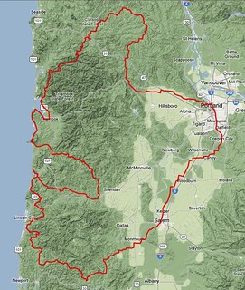
Prior to this fall, there were no 600+k permanents in the state of Oregon except for one that was part of SIR’s point-to-point from Washington State to Crater Lake. Now there are three; the SIR one, my Portland-Portland-Portland (which only got approved on Monday, which, alas, was after the snowline dropped below Cascade pass level and has either closed or made treacherous NF46’s pass between the Clackamas and Santiam watersheds. Oh, well, I’ll make it part of my (very late, after my shoulder heals) spring series) and Kevin Brightbill’s Grawp 711k extravaganza. Kevin and I have been goading each other towards 10k RUSA miles for the year (we are, I believe, currently the top two milage holders for Oregon; Kevin is the top milage holder for Oregon Randonneurs, and I’m about 1600km above him (I’m unaffiliated with any regional clubs, though when I rode organized brevets they were pretty much exclusively orrando ones)) and had been passing back and forth the idea of doing the permanent version of a Super Randonneur series (without, of course, getting any of the awards that RUSA or the ACP offer for completing a series of organized brevets; the motto for a Permanent Super Randonneur award would be “All of the fun, none of the credit”) so when his 700 was approved we had to ride it.
The original plan was to ride it on the 12-14th, but the weather forecast was for rain all that weekend but clear on the following (19-21st) one, so we pushed it off a week and rode my High Rock 300 for the last time this season (the high point of that ride is at ~4600 feet, and is sheltered enough so that whatever snow falls there stays there, as Ed Groth and I discovered last year when we did a checkride in June 2011).
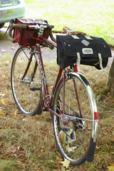
However, as the week progressed the weather forecast became progressively more gloomy, with it being a 50% chance of rain for friday,saturday, and sunday. And we were planning on a night start 700 (so we’d get to the overnight control in Oceanside before dark on Saturday) on Friday night. But the weather wasn’t getting any better, so we figured to bet against probability and just do it unless one of us injured ourselves, got sick, or had family emergencies. And, on Thursday, I got ready for the trip by running a fast populaire and borrowing a Carradice longflap saddlebag so I could carry a few more layers than I would normally carry. I’d bought a new pair of waterproof gloves & a rainjacket from REI, too, so I thought I’d be ready for most anything the fall could throw at me.
On Friday afternoon, I loaded up the mlcm and met up with Kevin for a 5pm departure. It hadn’t rained at all that day, but 30 seconds before 5pm it started to drizzle. Sigh.
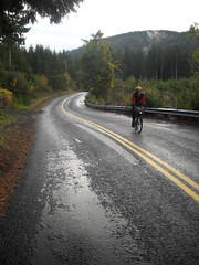
But, anyway, off we went, riding south through Sellwood into Milwaukie, then up and along River Road to Oregon City, where we climbed up onto the Boring Lava with the route I traditionally take down – the steep 5th/Linn Ave ramp. About halfway up that ramp, we were briefly stopped by a police barricade because a homecoming parade was coming down the ramp. The police nicely let us pass, because we could thread the gap between the parade and the curb, and as we finished climbing the ramp we provided great amusement to the people on the floats, who cheered us on and/or threw boxes of candy at us as we worked our way up the hill (Kevin stopped and retrieved some of the candy, but I just kept plugging upgrade without stopping because I’d already filled my handlebar bag to overfilling.) Once on top of the lava, we headed south towards Canby, passing through spots of drizzle mixed with spots where it wasn’t raining at all, but as we approached New Era we dropped down to a bridge in the drizzle, but by the time we climbed up the other side of the valley it was seriously raining. So a brief stop (I’d pulled ahead of Kevin here, so it didn’t delay us as much as it would have otherwise) to put on the new raincoat, and then we forged ahead into the steady rain.
But, sadly, the rain didn’t stay steady; we made it almost all the way to Canby getting nothing more than damp, but as we crossed 99e the skies opened up and we were competely soaked by a torrential downpour, which held steady for about 4 minutes before we waded out of the downpour and headed, at a considerably reduced pace, through Canby and southwards again (we lost about 2mph moving speed here, and never really got it back. Ugh.)
The route from Canby to Salem is basically the reverse of the Orrando Covered Bridges 400 loop, so it was moderately familiar to me. Going south here, and without 300km under my wheels, is a long faster and less confusing than going north has been in the past, so I didn’t have much trouble navigating through here even though my night vision is such that I can’t really read signs unless I’m right up next to them. We had a flat along here, which was annoying (Kevin’s rear Hetre collected a shard of glass, and, goodness, those tires suck up a lot of air before becoming even slightly inflated) but not overly so, because while we were changing the tube the sky cleared and let us travel the rest of the way into Keizer under the light of a quarter moon.
The first control was at a Safeway in Keizer, and we took advantage of this control to change out of our wet socks and continue on, still following, in reverse, the route of the Covered Bridges 400, slightly less damply.
At Independence, we headed west towards the Kings Valley Highway (along a route segment that we’d previously ridden on the summer 600) and into yet another band of heavy rain. Here I noticed an annoying thing; even though my gloves and rainjacket were keeping most of the rain off where they covered, I was still cold underneath them. My hands were dry, and the gloves had a nice fuzzy inner layer, but my fingers still got uncomfortably cold as the rainstorm progressed. And my jacket was waterproof enough to keep water from getting in (except at the collar,) but wasn’t particularly breathable, so everything inside it became very damp from sweat, which then had enough breathability to evaporate under my headwind and make the inside of the jacket very cold.
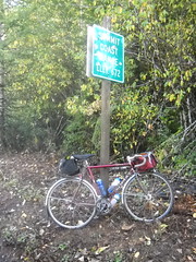
The rain had stopped again by the time we reached the Kings Valley Highway, but we still stopped at the Ritner Creek Bridge for a sheltered snack and relayering before we jumped onto the first scenic shortcut – Hoskins Road, which cuts off the extra distance of travelling down to Blodgett to get onto Summit Highway by the simple expedient of climbing across the mountain range directly to Summit proper. And it’s gravel, so a little harder to move at line speed on.
Halfway up the climb I needed to stop and strip off my rain jacket, which was interesting after I summited and followed Kevin down the other side, because the combination of cold+sweaty clothes+speed made me a very cold camper indeed by the time I caught up with him near the village of Hoskins. But I had managed to climb a pretty steep gravel ramp without stalling or spinning out, which was a nice change from the last time I came down here.
From Summit (the last 3 miles into Summit, on Mary’s River Road, were paved,) we dropped down into the Yaquina River valley and turned north onto Logsden Road at the village of Nashville. Logsden Road is nice in that it keeps people away from highway 20 (the main drag to Newport, so there’s always a lot of traffic on it; Logsden Road, on the other hand, had more deer/elk on it than it did automobiles) but not quite so nice because it goes to gravel where it climbs over Green Mountain. But that’s only a couple of miles, and then you’re basically going downhill most of the way to the Pacific Ocean.
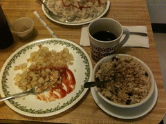
As usual, it seemed to take forever to do the 18 miles or so of Logsden Road from the gravel section to Siletz (it’s odd, because it runs through pretty countryside; even when it’s daytime it takes forever. At least it was close enough to dawn here so that we kept flushing deer out as we rode along – there was actually a point where I was riding ahead of Kevin where I flushed out a pair of deer who ran down the highway ahead of me for a little while before bolting into the underbrush to my right,) and it kept getting colder and colder as we wound along. We reached Siletz just after 5am, which was nice because the Little Chief Cafe opened at 5, and we could stop and have a leisurely warm breakfast before continuing. There’s not much I can eat at rural restaurants these days ‘cuz vegan, but hash browns, oatmeal, and coffee are widely available and I like them.
The staff and customers there seem to be used to seeing bicyclists come through, because they didn’t bat an eye at us except when we said we were trying to go from Portland to Portland in one go via the scenic route, at which point they were suitably impressed. And they didn’t mind when we stayed much longer than it took us to eat (we needed to get/put things on the bicycles, and every time we went outside it was “oh, lord, it’s cold out here” and we’d bolt back inside for another five minutes) and wished us luck when we finally pried ourselves out the door and onto the bicycles again.
From Siletz, we followed highway 229 north and towards the Pacific Ocean. It winds along the Siletz River, so you’d think it would be moderately level, but, no, it spends a considerable amount of time winding up and down various hillsides as it proceeds along (this explains why I thought during the 2011 600 that 229 went up to a plateau from the coast, then went through another range of hills before it reached Siletz) and I kept finding myself getting lost in thought, cranking up and over a bunch of ramps, then looking back to see that Kevin was a considerable distance behind me. *sigh* The morning is usually when I brood over things, but I don’t usually do it at 17mph.
It wasn’t raining, just cold, but sadly that would not last. As we turned towards the ocean (after 15 miles or so) we went under the edge of a marine effect storm, which was, at least here, cheerfully dumping rain upon our heads, and by the time we reached highway 101, we were both pretty soaked (me more than Kevin – he managed to score an experimental Goretex jacket as part of a test that Team Estrogen is running, which meant that he didn’t have nearly as much of the hot/coldhouse effect inside his clothing) and fairly chilled. My fingers were freezing at this point. They were still dry, but there was enough moisture in the waterproofing layers of the gloves to wick every bit of heat out of them, even with a pair of liner gloves to try and coounteract the coldification. But at least it wasn’t raining at highway 101, so we managed to dry out a little bit in the mile or so we stayed on that road, and for the first 5-6 miles of our run back into the mountains on Drift Creek Road, Anderson Creek Road, and the first 100 or so feet of Schooner Creek Road (aka NF 17.)
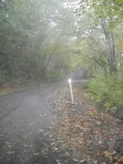
But after that 100 feet, two things happened. First, it started to dump down rain again, and second, the pavement ended and it became a gravel road (for the next 10-11 miles, too.) We first tried to park ourselves under the canopy of a tree to wait the rain out, but when the rain didn’t stop we said “to eff with it!” and waded out into the deluge and headed east (and up) along this scenic logging road.
And it was scenic. Now that I’ve got tires that are nimble on gravel, I can chug uphill on moderate grades at close to the speed I do on pavement, so I managed to pace Kevin eastwards and we came out from under the marine effect storm in almost no time. And then it was just winding upgrade on a thankfully not washboarded gravel road through regrowth forest, clear cuts, and the occasional house where the road came out of the national forest and into private lands. The summit was paved (it’s out of the forest, and there are about half a dozen houses here) but that pavement ended before the descent, which was, once again, gravel, but washboarded this time. Kevin vanished ahead (a theme on gravel descents on this loop) and I plodded along more slowly, looking cautiously for gullies and similar shoulder-separating obstacles, and caught up with him as he waited at the bottom.
And then we turned back and headed for Slab Creek Road along highway 18.
There are a couple of businesses at the intersection of highway 18 and NF12/Old Scenic 101 (which is what Slab Creek Road becomes when it summits Cascade Head) and we stopped at the Otis Cafe for a second breakfast and a change into our last pair of dry socks. The storm was no longer threatening to the west (it was, apparently, being blocked by Cascade Head) and the clouds had broken up so it was actually intermittently sunny, and we worked our way up the south side of NF12 without even breaking much of a sweat.
Slab Creek Road was, once again, the lightly graded route that I remember from this summer, and I’m going to have to make a 600 of my own that uses it one of these days. And where it dropped us onto highway 101 again there was a nice wide clean bike lane that took us all the way to the next control in Pacific City.
From Pacific City, it’s only about 22 miles to Oceanside, where the overnight control is. 22 miles by the direct route, that is; Grawp takes a far more scenic route by going back south to highway 101, then crossing the Coast Range (via the Little Nestucca River Highway and Hebo Road) to Willamina, then returning via Bible Creek Road (etc) and the Nestucca River Road, which makes it more like 90 miles. Oh well, we’re doing this for fun, and it’s now a nice warm sunny day, so it’s not a problem.
We shot (fsvo “shot”) east up the Little Nestucca River Highway, then dropped down into Grand Ronde on Hebo Road (which is still annoyingly grooved, but I’ve gotten better at pointing the mlcm between the ruts) and crossed to Willamina on, first, Highway 18/22, and then on Yamhill River Road, which is much quieter because it’s been cut at Highway 18/22 (we needed to hikeabike down an embankment to cross over to it, but that was only about 50 feet) and now has almost no traffic on it. We stopped in Willamina for the control and a snack (grocery store bananas and jellybeans for me, ‘cuz vegan (ish: I’m not sure about the origin of the food colors in the jellybeans. I’ll check that before the next 600)) before turning around and heading west again.
The pass at Sourgrass Summit is quite low and the approaches to it are fairly gently graded, but going back via the Nestucca River Road is not either of those. The traditional route of taking Meadow Lake+Nestucca River across is quite steep and climbs to about 2000 feet, and the route we were taking cuts off a couple of hundred feet from that summit.
But it cuts that off by first a dozen or so miles of fairly easily graded climbing along small rivers, then diverging and doing basically directly up the mountainside on Gilbert Creek Road (Gilbert Creek runs somewhere off to the west of Gilbert Creek Road, but I don’t think I would have noticed it if we were riding down the streambed) which resulted in some of the most horrifically steep climbing I’ve ever done. First you climb about 800 feet via super-steep ramps (15-20% grades) connected by short level(ish) sections, and then, once you enter BLM lands, it settles down to a constant climb of 7-10% for another 600 feet or so. The only saving grace of this insane climb is that there’s an almost identical descent on Bible Creek Road on the other side of the pass, which is great fun on a sunny day.
Alas, this was not a sunny day; as we climbed Gilbert Creek Road, clouds started to press in, and almost at the point where we tipped over the top and started to descend the spigots opened and freezing cold rain dumped down on us. So what would normally be a thrilling plunge down the side of a mountain became instead a white-knuckled attempt to creep down as debris sluiced across the road around me. Kevin, thanks to somewhat more worn brakes, vanished ahead of me during this descent, but I had quickly become so cold that I would not have been good company anyway.
When I reached the bottom of Bible Creek Road, I was chilled to the bone, and couldn’t warm up for the life of me – if I sprinted, I would warm up during the sprint, but then as soon as I slowed down I would be freezing cold again. We’d been planning on just riding directly through to Oceanside, but when we reached Beaver I had to stop and get some warm coffee and sit inside a warm building for a while before we could continue.
After about 20 minutes, we headed out again. It was not raining here, so the last (20, I think) miles started uneventfully; Highway 101 has horrible shoulders here, so the first 4 miles involved a lot of jockeying for position between us and the automobile/truck traffic, but not annoyingly so, and those four miles passed pretty quickly, as did the run up to Cape Lookout on Sandlake Road. Climbing Cape Lookout was actually not that bad (it’s more gradually graded from the south than from the north, so we could make pretty good time up it despite the 260 miles we already had under our wheels) and the descent down the other side was okay (the road is not in the greatest of shape, so I proceeded fairly cautiously down the ramp to where Kevin was impatiently waiting at the bottom. And then it was a simple run across to Oceanside along Netarts Bay.
So, of course, it started to rain, and then to pour, and then to hail, all of which was coming horizontally in from the direction of the Pacific Ocean. We were, of course, once again soaked, but this time I had the unpleasant feeling of having first my left side get soaked, and then feeling the wet creeping across my body to my right side. But, thankfully, we were almost to the overnight control, which, happily, was Kevin’s grandmother’s house right on the beach in Oceanside, and, more importantly at this time, with showers and clothes washers, so we could clean ourselves and get our clothing clean and dry before heading out into the weather again. (Plus we were fed, and got 2h15’s worth of sleep before eating again, loading our now clean and dry clothing back into our bicycles, then heading out.)
Refreshed, we rode out into the night, warmed ourselves up climbing Cape Mears, dropped (quickly and slowly) down the other side, and then rode around the back side of the cape into Tillamook, where we were planning on stopping briefly at the 24 hour Safeway there so Kevin could grab a space blanket and I could, I dunno, pick up some more sweets to snack on. But when we got there, we discovered that the “24 hour” part was a cruel lie and the store was closed. We stopped anyway, because it was starting to drizzle again and we wanted to get raingear on to avoid getting wet, then headed north along Highway 101 towards the Miami-Foley Highway (and then Foss Road, which, alas, we thought we’d transit in the dark and miss the scenery.)
Amazing how plans can change. The rain had been gradually getting stronger (to the point where I actually considered recommending that we pull off the road and shelter for a while in Bay City, but decided not to because we weren’t getting particularly wet) but when we were about halfway between Bay City and Wheeler it took a nasty turn for the worse – first the spigots opened and we got nailed with horizontal rain from the ocean, and then when we were thoroughly soaked it turned into a savage hailstorm that dumped enough hail to put between a quarter and half inch of hail on the ground.
Of course the hailstorm happened between towns, so there was very little shelter. When we reached the Miami-Foley Road, we ducked under a tree when the hailstorm slackened, but as we shivered there the hail intensified again and forced us onto the move again. A few miles on we reached the end of the marine effect storm and the hail cut out as if it had been sliced off by a knife, but then we worked our way along in freezing rain. We tried to shelter under another tree, but the wind blew the rain sideways enough to get us wetter, if that was at all possible, so we headed out again.
I do not like these REI waterproof gloves I purchased, nor do I love the REI rain jacket I purchased either, because they seemed to be engineered to suck in and trap cold, no matter what layers I had underneath them (wool gloves under the waterproof gloves didn’t work, nor did the three layers of wool (baselayer, cloud chamber jersey, thick Portland Cyclewear jersey) under the stupid rain jacket. And it didn’t take much more than about 5 miles after we were forced out from under the second tree before the rain stopped, the wind came up, and I started to seriously freeze, to the point where I was shaking enough to have trouble steering the mlcm. Kevin was far in the lead here, and I didn’t think I could safely catch up enough to tell him we had to look for shelter now, so I hopped off the bicycle and began to briskly walk it down the highway.
Riding a bicycle is a very efficient way to move around. Walking, not so much, which would normally not be a good thing, but at this point it meant that I was producing a lot of heat and not moving fast enough so that the horrid raingear I had would wick all of it away. So after a mile or so, I stopped feeling like I was hypothermic and was merely really really cold (at which point I caught up with Kevin, mentioned that I was feeling hypothermic, and we needed to find a sheltered place ASAP so I could warm up a bit.)
There are not that many open barns along the Miami-Foley Road, so we walked (and rode when I’d warmed up enough so I could ride without immediately freezing) another couple of miles before we saw a farmyard that (a) didn’t have a fence and (b) did have an open-sided shed right near the road. So we scampered in there, I took off the stupid jacket and gloves, pulled out my space blanket, wrapped it around myself, and scrounged up a bunch of food from inside my handlebar bag so I could crank my metabolism up to maximum heat production.
After 45 minutes or so, I was feeling less like a potential icicle, so we gathered up our stuff and headed out. But before we headed out, I shredded my mylar blanket and made a tinfoil hat to go under my cap and a tinfoil vest that went under my windvest, which was gratifyingly warm and warmed me up to the point that I was comfortable within a dozen miles.
But before that dozen miles we reached the end of Miami-Foley Road and turned right onto Foss Road, which was easily the high point of the loop. Foss Road starts out paved, but painted onto the side of the bluffs along the Nehalem River (the ex-POTB line to Tillamook runs along the river, but is in pretty sad shape these days – it’s covered with landslides and other debris now, and would take a considerable effort to get effort to put back into service again) but then goes abruptly to being a muddy path that is also painted on the bluffs along the river. Part of it used to be paved, because large stretches of it are partially paved with disintegrating asphalt, but most of it is gravel, stones, and mud.
But it had stopped raining, it was dawn, the scenery is spectacular, and I’ve got baller tires on the mlcm these days. So I could charge along after Kevin (on flats and upgrades; my shattered shoulder slows me way down on gravel descents, though I was moving a lot faster downhill after the Nomads demonstrated that they have excellent adhesion on rough surfaces (demonstrated by me not washing out a couple of times where I pulled the bicycle hard to one side or another to avoid a pothole; I could feel the wheels break loose, slide a little sideways, and then grab onto the gravel surface again before sliding out from under me.)
As I accelerated up a loose gravel ramp, the thought came to my mind that this must be what cyclocross is like, which is a dangerous thought for a middle aged ex-programmer with a shattered right shoulder.
This went on for about 18 miles before we came to the end of the gravel section (after a couple of false alarms where the road went to pavement for ¼th to ½ mile before going back to gravel) and were back on pavement for most of the rest of the loop. But by this time we were actually riding below brevet minimums, and, even though Kevin said he’d let us blow one control as long as we made up for it on the subsequent ones, I wanted to see if i could get to the control before it closed.
It was 5 miles away, mainly uphill, and there was only 18 minutes left until the control closed. I didn’t make it, though I came pretty close (this control is at the store+restaurant on Highway 26 at Jewell, which is about 600 up from the Nehalem River, and Foss Road goes up and down a few times here as it cuts across a couple of meanders before ending at Highway 26.) And then we lost another half an hour warming up before continuing onwards.
I’d never been on highway 103 before – it’s pretty nice. It’s not so much a country road as a suburban road; Jewell spreads along the road between Highway 202 and Highway 26, and rural fields are intertwined with country houses, farms, and schools, and the occasional business. And then, on 202, it’s only 20 miles over to Birkenfeld and the familiar (from the Birkie 200k that Orrando used to run) route on 202/47/Timber Road over to the Gales Creek Road and new roads east.
202 undulates a bit between the junction of 103 and Birkenfeld, so I opened it up on some of the climbs and pretty soon dropped Kevin, getting to the Birkenfeld store about 10 minutes before he did. I tried to restrain myself after then, but the chain on the mlcm was starting to get squeaky and when I was pulling Kevin down the road the rhythmic squeak-squeak of the chain was very lulling and I found myself actually falling asleep while riding down Highway 47, so I had to give up and either follow him or ride alongside for most of the way into Vernonia (when we got within 5 miles of Vernonia, I bolted ahead so I could stop at the Shell station there to grab some caffeinated soda and not delay us too long) and then, after Vernonia, we had just turned onto Timber Road when we went over a bump and my rear rim went scrape against the ground.
Oh, shit, another flat. I popped the rear wheel, found the puncture (a piece of beer bottle had daggered through the tire and into the tube) patched the tube, reassembled everything, and we were on our way. I was hurrying a bit because of this unexpected stop, and found that I had dropped Kevin before we even reached the Highway 26 crossing. Oh well, I might as well bolt over the mountain as fast as I can go and wait for him at the Glenwood control. (Or, as it turned out, I might as well stop and reinflate the rear tire when it went flat again just before Timber, then sprint as fast as I can the rest of the way to Glenwood so I can pop the wheel and put a different tube in before Kevin caught up. That almost worked; Kevin rolled in while I was still investigating the tire for additional pokey things, but he had cleaned out his handlebar bag and needed a lot of food now, so he bought food at the control and ate while I put in a different tube and reassembled the wheel.)
After Glenwood, we stuck together for the rest of the loop. We diverged from Gales Creek Road at Clapshaw Road, which is part of the most direct route across the valley that doesn’t involve riding along highway 26. There’s the tiny detail of having to climb up the cliffside that makes the west side of Clapshaw Hill (300 feet of hill with a really steep switchbacked road winding up it. Average 15% grade, maybe more – it starts out with a 20+% pitch, which drops down to “only” 10%, and then pitches up to around 20% again. I punched it and charged to the top of this hill as fast as I could go, but that ate up the remaining bits of my climbing speed right there) but once that was over it was a fairly level ride across the valley to the west hills. Night was creeping in as we rode across the valley; we reached North Plains at dusk, but by the time we reached Jackson Quarry Road it was nighttime and we finished the loop in the dark.
When we reached the last climb (Laidlaw/Thompson to the top of Tualatin Mountain, then Thompson/Cornell back to the bottom) I was starting to feel the effects of not having enough sleep. I was starting to have visual hallucinations, mainly perspective and imagining constructed artifacts from tricks of shadow and branches, and my energy was dropping off at an appreciable rate. I took this hill slowly, lagging well behind Kevin until near the top, when he ran out of steam (because he was big-ringing his way up the hill) and I churned past him in an embarrassingly low alpine gear. Going down the hill was worse, because Thompson is fairly twisty on both sides of the hill and I didn’t want to misjudge something and end up hurdling off the side of the road at 35mph, so I ended up liberally applying the brakes and creeping down the hill at maybe 20mph.
And then we were effectively done. A quick (for values of quick that include urban areas) transit of NW and downtown Portland, across the Hawthorne Bridge and over to Division Place, then up 8th to the Powell St. pedestrian overpass, across it, up 8th again to Boise, then into the final control, where I quickly signed and dated my brevet card, handed it over, and bolted for home with a “thanksbutIgottagoweshouldridethisagainwhenit'ssummertime!”
The final tally: 52h11 to ride 712km; a brevet average of a whopping 8.4 miles per hour (my moving average was a little more than 14mph, shockingly, given that it took us 4 hours to go 15 miles on the Miami-Foley Road.)
What worked? Almost everything. The historical reenactment bag I borrowed from Kevin was very nice for carrying extra clothing, despite weighing approximately 500 pounds, and I didn’t really feel it when I was trundling around the countryside. I can’t really say whether the Atac clipless pedals worked or not, because I wasn’t stomping on it all the way around the loop, but I did spend about 46 hours on the bicycle this weekend and my feet didn’t hurt, and that is after doing a 17.1mph brevet average populaire on Thursday. My layering worked, the mylar blanket worked, my food selection worked (all vegan, as far as I know; I can go a long way on potatoes, oatmeal, bagels, nuts, science diet, and vegan candy,) and, really, the only thing that didn’t work were those stupid REI waterproof gloves and rain jacket, which came really close to jeopardizing my life after the hailstorm on 101/Miami-Foley Road.
I’m now at 10200 miles for the year, and 9730 RUSA km. I’ll be over 10k/10k by the end of the weekend (I’m going to ride One Big Hill on saturday, probably by myself, and I’m going to do the checkride of my Estacada 100 tomorrow morning, so, modulo DNFs, I’ll have 10134km by next monday) and then the only bikey project I’ll have left is to see if I can get over 20,000km for the year (12400 miles; two months at 1000 miles a month in winter? That’s maybe doable, provided I’m not taken out by a nasty fall flu.)
Oh, yes, and I’ve now got two SRs for the year. One “official” ACP SR, and one Permanent SR (which isn’t recognized by anyone except me :-) If I was completely insane, I’d try for a second Permanent SR by reriding Hot Springs/Covered Bridges and Portland-Portland-Portland in the next three weeks (while there’s still a fighting chance of being able to get through the snows at the summit of NF 46) but I don’t know if there’s anyone I could convince to come along with me on this project.
Pictures? Check the usual suspect for them.