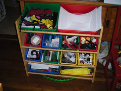
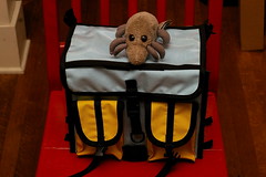
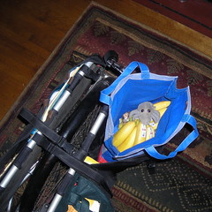
Four of the nine rando bags I’ve made (one of the other five is currently in pieces until I go out and get some new violently orange fabric for it, another – the first cordura bag I made for a Nitto F15 handlebar bag mount – is sitting in the mass of fabric and sewing bits that is my office, and the other three are no longer in my possession) over the past year and a half. Seven of those bags (starting with my original big rando bag) have been made since December 31st (when I realized that even though I had a rack, I didn’t have anything to put onto it and so couldn’t ride on the new years R200 that was being put on out on the west side) and I’ve finally started to get the production process down to the point where I don’t end up screaming and hurtling the half-sewn bag to the floor while I’m trying to sew the bias tape onto it.
I’m going to have to, sooner or later, buy or duplicate a Nitto front rack so I can have a fitting fixture that’s like 90% of the front racks out there. Right now I’ve just got photos of Nitto front racks with rulers photoshopped into them, and I’m absent-minded enough so that this isn’t the best way to do things.
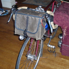
My preference in fasteners keeps changing, too. Rando style is all for elastic cords and toggle fasteners, but I’ve found that elastic cords are really a pain to fasten
when you’re threading them down between a decaleur and the handlebars (the MLCM has the handlebars placed much lower than the saddle, so there’s basically no room between my el-cheapo Velo Orange decaleur and the bars, plus toggle fasteners tend to rattle if they’re at all loose fitting when closed. So I’ve gone to adjustable sidelock latches instead, even on my historical reenactment fabric bags (I could use marine hardware, but (a) it’s hard to get and (b) it’s expensive!) and I’ll leave off revisiting that decision until a bunch of the bags have a few thousand miles under their belts.
And the newer bags are all lined; my prototype big rando bag isn’t, and the interfacing gets grubby really quickly and never really gets clean, even if I dump the bag into the wash. At least if the bags are lined (ripstop nylon is my lightweight liner of choice for the next six months or so :-) the lining will get all grubby instead.
—orc Tue Sep 27 22:33:01 2011
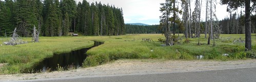
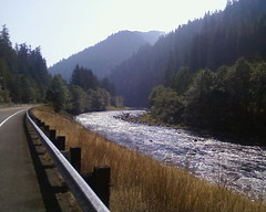
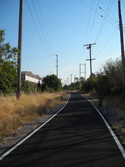
I’m building up an easier 200k permanent with as little climbing as you can reasonably do in the Portland area, but without going south through the farmlands of the central Willamette valley, and so far the best route I’ve found is to climb up into the foothills of Mount Hood by going up highway 224 to Ripplebrook Ranger Station and back. Sure, it does climb, but the vast majority of the climbing is along the banks of the Clackamas River with only one short steepish climb when 224 curves away from the river and climbs up onto the shelf that Ripplebrook is on. 4400 feet, I guess (and some of that is another steepish climb up Judd Road which I do to keep people off 224 on the way out to Estacada) which should make for a nice fast outandback loop even when you’re in the mood to noodle along taking in the sights.
So the route starts from approximately downtown Portland, loops out to Boring via what used to be Portland Traction’s Springwater line, then works its way over to Eagle Creek Road for a scenic run up to Estacada, then drops onto 224 for the run up to Ripplebrook, with one short detour off the line to take Faraday Road around the hideous climb 224 does up the side of the canyon and back down again. And from Ripplebrook, it’s a simple return on 224 down to Barton, where you divert onto Bakers Ferry Road, then onwards to Springwater/Clackamas River road, and (after an amusing dance to avoid the highway 213 mess down by interstate 205) north on River Road until you reach the ex-railroad, which you use to return to downtown. It’s all very nice, and if you aren’t surprised by the absolute and complete lack of services between Estacada and Ripplebrook Ranger Station, there are plenty of opportunities to stop for a little something along the way and back.
But first I needed to ride it to make certain that I was correctly remembering the loop and to see what the state of Faraday Road was these days. So last week, I decided to do the checkride on Saturday (my original plan was to go out to Central Oregon and ride Velodirt’s Stampede, but the start-of-the-school-year circus was even worse than usual this year, so leaving the house for three days was not in the cards. Sigh,) when it was allegedly not going to be so hot as it was at the beginning of the week. It’s just a 200 (and a flat one at that,) so I didn’t make any elaborate preparations for it – I just filled my new leaky water bottles (I now know where the water spigots are at Ripplebrook, so if I emptied the bottles before I got there I could fill up before returning,) slung some cookie bars and science diet into my big rando bag, and headed out within 2 hours of when I intended to depart.
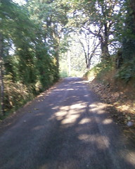
I started from home (I figured that if I did any rerouting or poking around on the loop that I’d make up for the 8km I’d miss by not riding downtown and starting there) and joined the loop at the foot of 17th, and then it was the traditional low-grade run out to Boring on the Springwater Trail (and Telford road for the last couple of miles where the Springwater Trail isn’t improved yet) which I did fast enough so that I actually acquired someone who wanted to take advantage of my slipstream (he passed me when the Portland Traction grade tips up near the eastern edge of Gresham, and I didn’t want to exert myself to latch into his slipstream.)
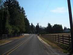
There are a couple of convenience stores in Boring that are used as controls, but I didn’t bother to stop because I just wanted to keep going for as long as I could. And past Boring Amisegger road undulates a bit, then drops down towards the Clackamas River and OR 224, which you don’t reach because Judd Road pops up and drags you up a fairly steepish ramp to the top of the bluffs, which are fairly well settled with farms and vanity farmettes all the way over to the end of the road at the junction with OR 211. And on the other side you zig, then zag, and then plummet off the edge of the cliff on an amazingly steep ramp on Van Curren Road. And when you reach the bottom, it’s not too far (and not too many turns) before you turn onto Eagle Creek Road, which takes you all the way into Estacada.
Eagle Creek Road basically parallels OR 224 here; the only advantage it has is that it’s a much less trafficked road that passes through more traditionally rural surroundings (except for the wall of churches just outside the Estacada city limits.) When I rode up it on Saturday, the blackberry brambles on both sides of the road were heavy with ripe fruit that was radiating the most intoxicating aroma as I headed on by – since this is September you’d not think it would be prime blackberry season, but it is and it would be a shame not to enjoy it.
In Estacada, you turn from Eagle Creek Road onto Wade Road, then onto 1st (either that or you’ll fly off the edge of a almost vertical 50' cliff. I don’t recommend doing this) and finally onto Broadway, which takes you right past the local Thriftway before depositing you onto 224 for most of the last 27 miles up to Ripplebrook.
There’s one detour on 224; if you exit at the exit to PGE’s eastside hydro project, that will take you past the Cazadero power plant and dam, and then onto Faraday Road, which used to be 224 before ODOT decided to route it over the top of the bluff. If you don’t exit here, you get to shave about a mile off the loop, but at the expense of a 7-800 foot climb that averages 7% (but in reality starts out much more moderately but pitches up to a really annoying level before you crawl over the top and plunge back into the Clackamas River valley.
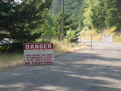
One of the things I wanted to check was whether Faraday Road was still closed after the landslide that clobbered it this spring. Unfortunately, it is, and PGE is very serious about making certain that nobody gets through into the construction area; not only are there these huge old KEEP OUT signs, but the chainlink barrier fences run quite a ways in each direction to keep people from hiking around them. So I had to turn around and wind, slowly, up the g-dd-mn ramp to the top of the bluffs, and then coast down to the other side where Faraday Road rejoins 224.
Just past the other end of Faraday Road is Promontory Park, which has a big sign just before the turnout mentioning that there are no services past this point. It would have been ungrateful to not take advantages of these services, so I stopped briefly and got something to drink before winding south again.
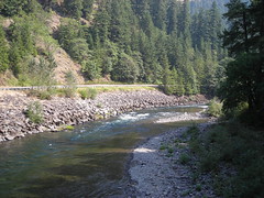
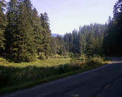
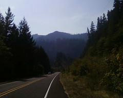
And from this point on it’s a pretty even grade as the road and river wind there way up into the mountains. Occasionally the road goes up a short ramp, then levels out to wait for the river to catch up to it, but none of these ramps are nasty enough to cause you any pain (for me, it’s usually “oh, why am I slowing down?” followed by looking off to my right to see that the Clackamas River is down a hundred feet or so and realizing that I just hit one of the ramps) and you can meander your way upgrade taking pictures if you so desire.
I pulled off the highway briefly at the Memaloose Road junction so I could go out onto the bridge and take a few photos, but my CBC chose that point to announce that the batteries were dead, and from that point on I had to use the even worse CBC that came with my latest used cellphone. (But at least I had a secondary camera this time around; on previous loops, I had to just stop taking pictures when the camera died!)
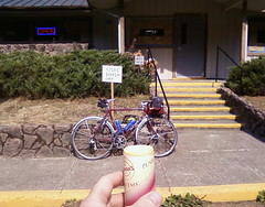
And then the road jumped over the river a few times (4 times), then curved away and ran up a short but steepish ramp to Ripplebrook. The ramp up is not the most pleasant thing in the world; the woods have been cut away around most of the ramp, so I climbed in the now getting fairly warm sun and was sweating like mad when I reached the top and rolled back into the woods. And then it’s flat-flat-flat for the last couple of miles until you roll past Alder Creek and into the parking lot for the Ripplebrook Ranger Station, which has a little store that I stopped at to get a little something that included ice cream and salt before I turned around and headed down the ramp toward Portland. I’d made it up there in 4h45, which was a surprisingly fast rate given that I had paused for snacks and photos, and was thinking that this would be a surprisingly quick loop after all.
But what surprised me when I made it back to the top of the ramp down from Ripplebrook was that it had gotten much hotter and windier, and the wind was coming up the river valley towards the mountain. So instead of just coasting all the way back to the southern end of Faraday Road. I had to work to push my way down the mountain, and by the time I reached the first services at Promontory Park, I was toasted to a light crunch and had to stop to get some nasty sports drink and another ice cream cone before I could wind my way back up that horrible ramp on the Faraday Road bypass (I checked Faraday Road from the south before I did this, and it had much the same sort of barracade as it does from the north, but there are no signs telling you the road is closed until you’re about 600 feet from the barrier. Oh well, an additional 2.5 miles is good for the soul.)
At least the ramp isn’t quite as steep from the south, and the road was sheltered from the wind as I climbed back up to the top of the bluff, and when I reached the top I was pretty much done with the climbing for the day, and could coast down towards Estacada without worrying about anything other than the headwind.
The route takes you along 224 between Estacada and Barton, but Eagle Creek Road runs parallel very closely to 224, so you can detour up to it without suffering a horrible distance penalty. I was planning on sticking to 224, but when I reached Ely Road (which had a sign warning that it was a narrow one-lane road) I couldn’t resist and had to detour over to Eagle Creek Road for as far as it would take me (it deadends at highway 211, at which point I needed to zig back to 224 for the last 3-4 miles into Barton.)
At Barton, there’s yet another convenience store, which I took advantage of for another ice cream bar and more nasty sports drink (the bottle I’d consumed between Promontory Park and Estacada had a gratifying recouperative effect, but I’d started to run down substantially after I left Estacada behind) and then bid farewell to 224 for the allegedly less trafficked Bakers Ferry Road. “Allegedly”, because it had become a hot day and from Barton Park north the banks of the Clackamas River were stuffed full of people who had bolted for the coolth of the river on a very hot day instead. As I rolled along Bakers Ferry, I kept seeing things I wanted to photograph, but no sooner did I have my cellphone out than a long line of cars would go whizzing by, preventing me from taking the picture I wanted to take until the view had receded behind me. And this lasted all the way until Oregon City :-(
And then, after a bit of detouring to get around the construction at the i205/highway 213 interchange, I was back on River Road and creeping slowly towards home. I’d run out of the second container of nasty sports drink, so I stopped briefly at the Burgerville on River Road to get some fries (but this was the 50th anniversary celebration there, so food was cheap and the restaurant was stuffed full of people, so the brief stop became more like half an hour) and then staggered on towards home.
When I reached the intersection of Spokane & 17th, I was about 5 miles shy of my 200, so I looped down to the Springwater Trail and rode a couple of miles into town, stopping only when I ran into a friend who was going the other way; I turned around, and we rode back towards my house at a conversational rate, and when I peeled off two blocks from home I’d ridden just over 125 miles (I’m not exactly sure, because my gps stopped recording just south of Estacada and I didn’t realize it was stopped until I was between the highway 211 junction and Barton. But I’d remembered the distance I was at when I went past the south end of Faraday Road, and I had followed (with the exception of some extra distance working around the highway 213 construction) the route from there, so I could compute the distance on the fly.
The gory details of the ride are
- 125(ish) miles
- in 10h45 minutes
- 5 stops for food
- and 57 pictures
When I got back home, I was caked with salt crystals and needed to take a shower before I could even sit on the furniture. This probably explains why I was so toasted half way through the loop; I’d sweated away all of the excess salts in my body and couldn’t do more than stagger along until I corrected that imbalance. The water bottles I carry on the MLCM have the horrible feature that they tend to aggressively leak, and so I quickly got out of the habit of carrying gatorade after coming back from a couple of brevets and having to break out the goo-gone to get the sugar water deposits off the frame. This is turning out to have the unfortunate side-effect of stopping the flow of salts into my body to make up for the flow of salts out of it, and I’m going to have to find a way to work around that misfeature one way or another.
—orc Mon Sep 12 15:43:42 2011
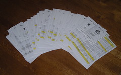
You can already see what the return times were by looking at timestamps on my photos, but here they are in a less scavenger-hunty style:
| RUSA No. |
Last Name |
First Name |
Finished in |
|
BIER |
Jerry |
12h37 |
| 691 |
BINGLE |
Michael |
8h09 |
| 1992 |
CARR |
Norman |
11h50 |
| 6814 |
CHASTAIN |
Asta |
8h09 |
|
COPPA |
Jim |
10h26 |
| 6805 |
EASTMAN |
James |
10h53 |
| 3821 |
F********* |
Lynne |
11h03 |
| 5099 |
GITCHELL |
Stephen |
10h26 |
| 6665 |
GOOD |
Ryan |
12h01 |
|
HOGAN |
Dennis |
11h52 |
|
KANGAS |
John |
12h01 |
| 6726 |
KASPER |
Steven |
8h09 |
| 6666 |
LEE |
Rodney |
12h37 |
|
LEVY |
Vincent |
10h53 |
| 2917 |
OLSON |
Greg |
9h21 |
| 628 |
SCHARFENBERG |
Del |
8h06 |
|
WILSON |
James |
10h26 |
| 5475 |
YOUNG |
Michal |
11h03 |
Theo, Ed, and I finished the preride in 12h27, btw; and one of the things we stopped for was to find info questions for the Stabler (no longer a) Market info control. However, in the two weeks since we did the preride, two of those info questions were removed (we had questions about the gas pump that was out in front of the market; the last price on the pump was $2.29/gal for unleaded, so the pump had been there for a long time. Not anymore; when Ed got out there for the secret control, the gas pump had been removed and had been made much less useful as an info control!)
It was a sparkly clear day (except for the smoke from the forest fires that reportedly made the return trip more scenic and spooky at times) and I would much rather have been out on the line than sitting in Wilshire Park signing people in, but if you’re going to have Portland-based brevets someone is going to have to organize them, and who better to do that than the people who reeeeeeaaaaaalllllyyy want to have them here?
—orc Mon Sep 5 11:03:45 2011
Five months and two days ago, I ordered this Apple Time Capsule from the Apple Store (I wanted an easy way to do backups from all of the macs here, and I didn’t want to do periodic rsyncs to the much-too-small-for-backups freebsd server that’s been squatting in the basement for the past 5-6 years,) plugged it in, and after two days for the initial backup from the pair of laptops had it settle in to doing hourly backups without fuss muss or bother.
Recently (in the last couple of weeks) I noticed a couple of times where backups would just lose track of the disk and have to be reconnected to the Time Capsule. The network has been kind of flakey, so I wrote it down to that, but sometime last night (a little less than 5 months since I installed the unit) I got the big YOUR BACKUP DEVICE IS SCREWED! message:
~~~
Sep 2 01:34:34 pancake library storage: Volume dk2 on Disk sd0
(SAMSUNG HD103SI 1AG0) needs repair (256).
Sep 2 01:34:34 pancake library storage: Volume dk2 on Disk sd0
(SAMSUNG HD103SI 1AG0) failed to mount (256).
~~~
And then when I did a diagnostic reboot this morning, the Time Capsule just didn’t come back.
Oh, now that’s quality engineering for you. At least the g-dd-mn thing is still under warranty, so I can take it down to the Apple Store and, maybe, get the disk removed and replaced with a working part (and maybe get the warranty extended out to a year from the repair? It would be nice to not have to have a 6andchange month warranty period on the new disk.)
—orc Fri Sep 2 12:45:50 2011