Anything worth doing is worth doing twice
I’ve been spending most of my breveting energy on riding the eff out of routes like Portland-Ripplebrook-Portland, One Big Hill & Silver Falls and Volcanoes vs. Farmland and have left Hills to the Yeah! and Sellwood-Birkenfeld-Sellwood almost untouched (ridden them once each this year.)
Of those two, I’d left Sellwood-Birkenfeld-Sellwood alone the longest, so when I was arranging a weekend 200 with my friend Kevin, I mentioned that I was interested in trying to do a sub-10 hour run of this loop. Kevin wasn’t so sure about the sub-10 part, but it had been a while since he’d ridden out to Birkenfeld so he thought that this would be a better bet than my other suggestion (which was to try for a sub-8 One Big Hill; that may have to wait until November) and we were on for a nice 8am departure from Marsee Baking.
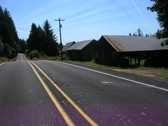
Which I was late to, as is traditional (this time I was late because I’d forgotten to print out the waiver and brevet cards before, um, 7:55am) so our 8am departure became an 8:07am departure. We worked our way north through Portland, being stopped by every single freaking stoplight on the way, until we reached Willamette Boulevard and could scoot along towards St Johns, the St Johns Bridge, and the long tedious stretch of highway 30 between Portland and Scappoose.
On the way up towards the Sauvie Island bridge, Kevin and I rolled smartly along at about the same speed, but there is a short series of undulations immediately after the bridge, and I found myself, with my newly found climbing speed, popping over these bumps and leaving Kevin far in the rear. So I slowed down, waited for him to catch up, then starting accelerating north just to get the eff off highway 30 again. And dropped him again on the next series of hills just south of Scappoose.
Sigh. I’m just not used to this newfound climbing speed I’ve developed. Another round of slowing got us coalesced again as we reached the central part of Scappoose and the turnoff onto the Scappose-Vernonia highway, where Kevin had the idea that it might be nice to follow the CZ haul road instead of riding on the highway.
Can’t argue with that; the highway is nice and fast, but has about a centimeter of shoulder, while the CZ trail is nice and quiet and winds upgrade along the edge of the valley.
It’s also mainly gravel, with some sections that are fairly battered. And this slowed me right down, to the point where Kevin took the lead all the way up to the summit of the Nehalem Divide.
Columbia County has been slowly working on making the CZ haul road into a nice trail, and almost every time I’ve ridden on it since my first loop I’ve seen one thing or another being fixed up. Last year, the huge washout on Mollenhour Creek was filled (and paved with extremely coarse mill run gravel which I’ve walked every time I’ve gone up the CZ haul road since then) and this time the other washout (Alder Creek, east of Spitzenberg) had a honest-to-g-d bridge put in. This latter improvement is greatly welcomed, because fording Alder Creek was a bit of an adventure due to a tangle of downed trees across the shoofly down to the ford, which meant that bicycles needed to be lifted over waist-high trees or put on their sides and slid through the mud along with their riders. It’s not a perfect improvement yet, because for some reason the bridge was installed halfway down the embankment into the ravine and then the new steep ramps to it were paved in a thick layer of fine pea gravel, which neither Kevin and his Hetres or I and my Nomads could climb.
But, anyway, Kevin shot along this trail and I followed cautiously behind, only dropping to my alpine ring for the mile and a half 9% ramp that went from where the haul road diverged from the old Columbia & Southwestern ROW to the summit 700 feet or so up from there. And when we reached the top I suggested that it would be a lot more fun to descend on the highway than it would be to descend the haul road (which is still fun, but my shattered shoulder might have had words to say to me if I wiped out on the large patch of loose gravel at the first hairpin on the descent) so we climbed up to the highway and proceeded to drop down to highway 47 and the Nehalem River.
Have I mentioned that 28mm Resist Nomad tires are the bees knees? When I was riding Ruffy Tuffy tires, I descended about as fast as Kevin did (and I suspect not nearly as fast as any of my other riding partners present or past), but on this day he led out on the descent, but as it steepened the mlcm accelerated as if it had been dropped from an airplane, and I shot past him and plunged into the valley like a rocket.
Eventually I slowed down, then stopped for a snack and to delayer, and waited for Kevin to catch up. And then we were off again down to highway 47 and the north. 47 is a fairly level road through here, so we were able to shoot northwards at a reasonably fast 20mph, each pulling for 5-10 mile stretches until we climbed over a knee of the valley wall and dropped into Birkenfeld.
We pulled into Birkenfeld approximately 4h30 after we left Portland, which wasn’t bad considering the long gravel section. But at Birkenfeld we stopped at the (no longer a store, but a cafe/music hall) Birkenfeld Store for a leisurely lunch, and were well over 5 hours into the ride by the time we got back onto our bicycles and headed south.
If anything, the return from Birkenfeld down to Vernonia was even faster than our trip north from the highway junction at Pittsburg; Kevin pulled us along for 3-4 miles, then I got into the lead and stomped on the gas and yanked us along at 20-21mph for about 15 miles, only slackening when we got close to Vernonia.
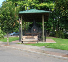
We didn’t need to stop for anything in Vernonia except water (we were both sucking down water like firehouses) so our stop there was very quick – enough time to refill bottles, then take photos of steam locomotives, and then we were off on the Banks-Vernonia trail for the next 20 miles down to Banks. This was not a part of the ride to go particularly fast, so we idled along at 15-16mph and chatted most of the way up to Tophill, then most of the way down to the valley floor north of Banks (I was trying to coast all the way down to the valley floor, so I lagged behind for a goodly chunk of this trip :-), then into Banks proper, where we refilled our water again and headed towards Tualatin Mountain and points east.
Now, here we needed to do a bit of a reroute. Washington County removed an old bridge on Old Cornelius Pass Road a couple of months ago, and is planning on reopening the road on September 22nd. But it’s not September 22nd yet, so we needed to find another route. Last time around we detoured onto Logie Trail, which was nice, but steep, and would have been a bit out of the way for this loop. I was thinking of Cornelius Pass->Kaiser->Brooks->Skyline, but Kevin suggested West Union->Laidlaw->Thompson and I thought it would be worth investigating.
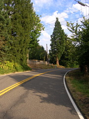
It certainly was. Laidlaw is steep, but not as steep as Logie Trail, and Thompson is steep, but steeper near the bottom than the top, and once you get to the top (I actually shifted out of my alpine ring back to my big ring halfway up Thompson :-) you get to go down Thompson, which is now all the way open again. And, my, the descent down Thompson is great; there were a couple of places where I needed to scrub speed going into a 15mph hairpin, but for the vast majority of the descent all I needed to do was to try to stay in an aero tuck and keep my glasses from blowing off as I plunged down the hill.
Unfortunately, it turns out that the Thompson Road route is about 4 miles shorter than the Old Cornelius Pass route, so I’m going to have to shuffle my control points to force people up Old Cornelius Pass Road. But by the time I discovered our milage shortages here we were already down the hill and in Portland proper, so I had to make up the milage by looping around the southern edge of Sellwood on the Springwater Trail.
At least it made it more of a nonoverlapping loop!
We finished the loop in 10h58, which was not the sub-10 I was hoping for, but it did include a slower climb up a gravel road and a long lunch in Birkenfeld, so the sub-10 here is not completely out of the realm of possibility.
And I did verify that I can take pictures at 20mph even if some of them don’t turn out as I expected.
Gonna have to do it again, and this time all on pavement, when Old Cornelius Pass Road is open again!
7050 RUSA km now, and 8150 miles for the year. Operation “Ride the eff out of my bicycle” is progressing as planned.