Permanent 1134 – Hills to the Yeah! – 201 km
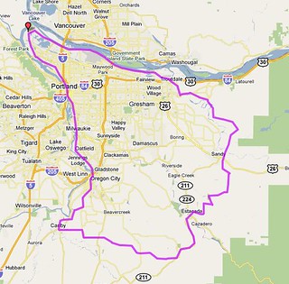
I’d like to say that I built up this permanent by picking scenic roads around Portland and then stitching them together with direct connections (like the organizers of d2r2 used to claim before the event became popular because of those allegedly “direct connections”), because it does go over some very nice stretches of road and only suffers from rando-style “we gotta add some kilometers to push ourselves up to 200k!” dyslexia in the last 40 miles of the route, but, no, this was the result of a game of chicken between me and my friend Ed where I’d make up a route, say “enough climbing for you?” and he’d say “sure, but it would be more fun if you did <x>”
In any case, this is a tour of scenic roads south and east of Portland that features miles of quiet country roads travelling through quiet farmland, woodlots, and the remains of old farming villages. It also features long fast descents off the top of various bluffs and mountains where you can zoom downhill on good pavement for miles and miles before you reach the bottom of the ramp. It also features some climbing; about 9000 feet of it, in fact, often at grades around 10% for a larger fraction of a mile than you’d want it to be.
And then it deposits you into the city on Marine Drive for a fast run along to Columbia to the confluence of the Willamette, and then south along the Willamette back to home.
You start, as is traditional with my brevets, at the corner of Milwaukie & Bybee (Marsee Baking is a good place to start, since it opens at a reasonably early time of day) and then head south into Clackamas County. A quick run down to Oregon City on River Road (alternatively you can request to use the Trolley Trail to avoid the fairly steep approach to River Road. I don’t mind if you avoid this climbing, because there are plenty of other ramps that you need to deal with before you are done) is followed by a steepish climb up the Boring Lava, and then an equally steep drop off the other side as you work your way south towards the town of Canby, where the first control (and the last on-route services until Estacada) is located.
From Canby, you turn east and climb right back up onto the Boring Lava again as you head towards Highland Butte and Estacada. The climb starts gradually as you climb up towards Central Point Road, stays gradual as you turn south, then swing eastward on Union Hall Road, and then goes up abruptly to an intersection with highway 213, and soon afterwards gives up most of that elevation as Buckner Creek Road plunges down into the Buckner Creek watershed (if you’re watching carefully, you might be able to spot where the Willamette Valley Southern crossed the road 85 years ago) and then demands that you pay for that descent by climbing up to the heights you just departed via a short 2km ramp.
(You’ll notice that each of these steep climbs are along nicely wooded cliffsides or creeks. The advantage of building roads up nearly vertical cliffs is that they tend to stay wild longer than they otherwise would.)
Once you’ve finished this climb, you roll along going gradually uphill for a while. There are many small farms here; you’ll pass by some grain fields, filbert orchards, and many many hobby farms with alpaca, goats, sheep, and emu. This area might seem thinly populated, but there are a lot of people living around here, and you’ll pass by a school to prove it. Eventually you reach Beavercreek Road (if you frantically need supplies, Clarke’s General Store is about 4 miles north – Molalla is about 8 miles south of here, but it’s all downhill and you’ll have to climb up to get back to the source if you go that way) and the road starts climbing a little more enthusiastically to get up to the upper plateau of Highland volcano, and then it turns a little bit southward to roll along the edge of that plateau towards an intersection with highway 211.
This is christmas tree farm and tree lot territory, and not much else. There are some small farms and rural houses here, but you’re mainly travelling through treelots of one sort or another here.
And then you reach highway 211, which takes you up a little ways, then drops you down into the valley of Clear Creek, which you then have to claw your way back out of before you get to the descent into Estacada. But that descent doesn’t happen for a while, and you ride along the (fairly) quiet highway through a small collection of nurseries and farms before the road pitches downhill and drops you – on six miles of smooth pavement – all the way down to Estacada and the next control.
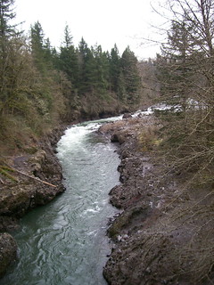
It’s not that far from Estacada to Sandy (the next control) but it’s not any less climby than the previous 28 miles were. From Estacada, you work your way up and out of town (6th St->Coupland Road) until you can cut over to Snufflin Road, which rolls through farm and range for a couple of miles before dropping you down (via a steep and twisty descent) to Eagle Creek, which is pleasantly undeveloped and a joy to ride downstream along. But, and there’s always a but, you shouldn’t relax too much, because just the other side of Eagle Fern Park you turn right onto Kitzmiller Road, which, after a short level stretch, proceeds to go up for a considerable time until it deposits you onto a spur of the Cascades above the city of Sandy.
It’s flattish here; you do work up to about 1200 feet before you descend into Sandy, but the top of the plateau here is cut with deep valleys and you’ll plunge into and winch your way out of about 3 of them before you reach 1200 feet and start descending towards Sandy.
One treat you’ll find when you drop towards Sandy (after you turn onto Trubel Road) is two nice parabolic valleys that the road climbs into and out of. You’re going slightly downhill here, so if you punch it on the way down into the valleys your momentum will almost pop you up the really steep looking climb on the other side, and if you keep pedalling like mad you’ll sail up to the top without doing more than breaking a mild sweat.
But after this (and two other parabolic valleys on Langensand Road that only 650b randobikes will be able to appreciate, because the pavement here is not very good) you find yourself in Sandy, where you are required to go to Joe’s Donuts because on this ride it’s not only a good idea, it’s the law.
And after you depart Joe’s, there are only two more serious climbs left to do before the final runout in town.
Cross highway 26 and get onto Ten Eyck Road, which goes down really steeply into the Sandy River gorge. Cross the Sandy River, then climb back up to where Roslyn Lake used to be, and then fall down into the Bull Run watershed before the last big climb. It takes about 3 miles to go up 900 feet, and then you ride along (generally going down, but with some climbing) until you reach Multnomah County again, where the pavement immediately improves and the road tips downwards for about 10 miles.
Here you can fly downhill with minimal effort at 20-25mph. The grade slackens a bit 2/3rds of the way down (where Bull Run Road becomes Gordon Creek Road) but almost immediately pitches downhill quite sharply into a twisty (but not terrifyingly so) plunge down into the Sandy River valley (be aware, however, that the last half mile of this descent switchbacks down the side of a bluff; when you see the truck descending a triangle roadsign you want to slow down because there are two stupidly steep switchbacks right up ahead.
The bottom of this descent puts you down by the Sandy River across from Oxbow Park, which, if you’re at all familiar with the roads around here, doesn’t actually have a water level route across the Sandy from it. No, this little stretch along the Sandy River is followed immediately by the last big climb of the day – 300 steep feet back up to the top of the gorge, and then a mile across to Hurlburt Road, which bounces a couple of times, then points down and drops you onto the Historic Columbia River Highway, which takes you all the way to Troutdale (where there’s yet another control) before expiring.
And now there’s basically no more climbing at all, and you can make up some lost time as you skitter along Marine Drive all the way up to Kelley Point Park, and then from Kelley Point Park through St Johns and down again into Sellwood.
And then you’re done, and the only climbing you might have to do is to get up the step into the Tri-Met bus you ride home (or to your hotel) on.
A stack of pictures from the checkride can be found on flickr, a cuesheet can be found here, and if you want to ride it for RUSA credit you can contact me at this convenient hyperlink.