Permanent 1301 – Volcanoes vs Farmland – 205 km
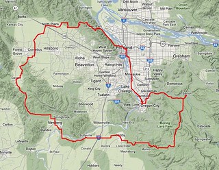
There are only two big climbs here, and they aren’t that big; you climb ~1200 feet up the slopes of an ancient shield volcano, and then, after a long period of ambling through farmlands and wetlands, you climb another 1000 feet up Tualatin Mountain, but then descend back into Portland before you reach another vent(Sylvan Butte) and end up your day with officially 3800 feet of climbing.
As is traditional, the loop starts in Sellwood (in the vicinity of Milwaukie & Bybee – the Marsee Baking shop on Bybee is a good place to start, but it is an open control so you can start anywhere in the vicinity as long as you end in the same place – and heads south. You take 17th Ave south into Milwaukie, then work your way along the river on bicycle paths and side streets until you’re plunked – after a short but kind of steep climb – down onto River Road, which takes you down to the first info control in Oregon City. And from Oregon City, you proceed east along the Clackamas River (with a little bit of dodging into the city to avoid a long-standing construction project at the foot of highway 213) through the town of Carver and across Baker’s Ferry Road all the way to the first timed control in Barton.
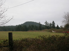
Turning back from Barton puts you onto the first climby section as you work your way up to Ridge Road , which you then follow up the slopes of the volcano until you are almost to the main vent complex at Highland Butte. Ridge Road ends here, and so does your climbing, as you turn west and descend towards Canby (a large chunk of the descent is on Buckner Creek Road, which is an insanely steep climb going the other way, but which is a lovely, if somewhat bumpy, descent going east to west) with only one short climb in the middle of the leg (Buckner Creek Road goes all the way down to the bottom of the gorge that Buckner Creek dug out, and then has to climb a couple of hundred feet back up to the top of the Boring Lava; if you’re a keen-eyed trainspotter, you can spot where the Willamette Valley Southern crossed Buckner Creek Road almost 80 years ago) to break the mood.
The route takes you out of the country and crosses through Canby about 50 miles into the ride. There is no control here, but if you want to stop for a snack and can’t wait another 14 miles to Newberg, there are a few restaurants and stores (including Cutsforth’s Thriftway, which is one block north of the route just west of the SP mainline) that you can stop at. And then, almost before you know it, you’re back out into the country and rolling east towards Newberg.

It’s very very flat here, and the roads are narrow and shoulderless, but you don’t spend much time rolling through the flatlands before you bend north and drop down into Butteville, then work your way – briefly on Butteville Road, and then on a bicycle path – into and through Champoeg State Park, where you can get water and use the bathrooms at the visitor center before jumping back onto Champoeg Road for the last half-dozen miles into Newberg.
Newberg is officially the halfway point (it’s a little more than halfway, but it’s pretty close) and is a good place to stop and have a more substantial meal. (If you’re fast, it might come a bit early for a meal, but there’s really not much else in the way of sit-down food for another 30 miles past here unless you go a ways off course to find it.)
You head north to get out of Newberg, but the route turns back to the west in ample time to avoid a climb of Bald Peak. You’ll cross a short section of gravel road just west of Newberg, but then you get back onto pavement for the rest of the loop.

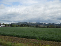
The route between Newberg and North Plains travels mainly along farmlands, but it also goes along the historic shoreline of Wapato Lake, which is slowly being reverted back to marshlands. You may not hear them as you go by, but there is a huge population of frogs in the Tualatin River/Wapato Lake wetlands and on spring evenings the sound of them croaking is deafening.
As you head north, the valley tilts slightly upwards as you approach North Plains, but the climbing doesn’t begin in earnest until after you’ve transited North Plains and are heading back east. The fast route back to the east is to take West Union to Germantown Road, but it’s a very heavily trafficked road that doesn’t have much of a shoulder, so you dodge north on Jackson Quarry Road to take secondary roads east to Skyline. The secondary roads have much less traffic, but they pay for that by being considerably more vertical, and you end up doing a lot of climbing as you proceed from the south end of Jackson Quarry Road up to Helvetia Road and then over to Old Cornelius Pass Road via Phillips.
And then there’s Old Cornelius Pass Road, which runs uphill for a considerable distance without relenting, and then spits you out onto Skyline, which also runs uphill for a considerable distance before it relents. And then you’re basically done with the climbing; there are some rollers before you reach Germantown Road, there’s a short ramp up to the St Johns Bridge (which you don’t go over; it’s simply the shortest connection to town instead of turning left and going north down the ramp to highway 30) and then an even shorter one that takes you up and around Montgomery Park, but that’s it.
But first there’s Germantown Road, which drops precipitously off the side of Tualatin Mountain and hairpins its way down to highway 30. And at the bottom of that, you’re on highway 30, which is an unpleasant, but fast, 3 miles to the junction with St Helens Road, which takes you into town for the last half dozen miles of city streets and bicycle paths back to Sellwood, where you can sign off on your cards and be done with it all.
A cuesheet is available here, and if you want to ride this for RUSA credit contact me at orc@pell.portland.or.us.