DNDNF
The last time I rode Volcanoes vs Farmland was a catastrophe that kicked off a rolling series of disasters that continue to this day (say hello to my shattered shoulder; it hurts basically all the time, partially because my now-disconnected clavicle rubs against my scapula and the muscles that drive my upper arm, partially because the stupid thing is only kept from popping out by the skin on my shoulder, which is probably developing one hell of a callus on the inside. I might be able to get it kludged back together, but that will require not using my right arm at all for four freaking months so I’m trying to do as much riding (and programming, and sewing, and brazing, and rack fabrication, and bicycle construction, and basically anything else I can think of other than sitting around and collapsing into what would be a suicidal depression if not for antidepressants) in before I finally snap and have the surgery (the surgeon I talked to basically said “you’re old, you don’t have enough years left to want to take 4 months off from life.” Um, thanks, I’ll remember that if I crash and the clavicle tears its way, Alien-like, out from the inside.) And that’s just one of the disasters) so when my friend Kevin suggested it as a ride option for the midweek permanent, I figured that my only goal for it would be to finish the day without it being another catastrophe.
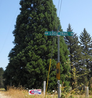
I’m not sure what Logie Trail Road has to do with not being another catastrophe.
You might ask “What does Logie Trail Road have to do with this permanent, which when I look at the cuesheet I see it goes past Logie Trail and climbs Skyline via the much more moderate ramp on Old Cornelius Pass Road?” Well, it’s like this; Old Cornelius Pass Road is closed for a bridge replacement and I needed to find an alternate route. The official alternate route (New Cornelius Pass Road) is too urban for the theme I’m trying to do, the unofficial alternate route (Germantown Road) is being chipsealed and is now a mass of drifted gravel, and any other routes over the Tualatin Mountains are too far into the UGB to give me the slow wrapping yourself in the city as you come down Skyline, Germantown, and US 30 into the center of Portland.
But Logie Trail Road isn’t urban. And it’s supposedly a nice, if kind of steep, climb, which would make it a nice bookend to a route that starts off with another nice, if steep, climb. And that would make this loop a nice successor to last Saturday’s Hot Springs-Covered Bridges 400, which turned out to be a little more insanely climby than I’d originally thought.
I looked at the weather, which was going to be nasty – it would start out the morning in the low 60s, then slowly work its way up to a high of about 95°F at between 4 and 5 pm – and suggested that we start at 6am and move around the loop smartly so we could finish in the ballpark of 4pm. Kevin thought this was a fine plan, so we met up near Marsee at ~6am, did the paperwork, and headed off to the south, via the traditional route (with one variation; When Tri-Met finishes the section of the trolley trail they’re supposed to be building I’m going to reroute all of my relevant permanents to use it, but for now I reroute the permanents I ride up 99E to Park and then onto the Trolley Trail) out to Barton, where we’d turn back to climb Highland Butte.
As we rode along Baker’s Ferry Road towards Barton, I couldn’t help but notice that the lower bluffs were obscured by a layer of extremely low clouds, which didn’t seem to show any interest in going away. After we turned around in Barton and headed back, the clouds were still there at about 300 feet ASL.
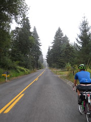
Climbing Harding Road put us into the clouds. Dropping down to Fischers Mill dropped us out of the clouds, but as soon as we climbed up the first ramp on Ridge Road we were back in the clouds, where we stayed for a good long time.
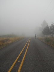
This was not a moderate overcast, either. Everything, including us after a little while, was wet and drippy from the moisture and there were long stretches where we were almost feeling our way through 50' visibility. It got lighter when we reached the summit of Ridge Road (I think we were almost poking through the top of the cloud cover here) but our descent was back into the thick damp fog.
I’d brought my vest along for paranoia’s sake, and was glad I did – the descent from Highland Butte was stupidly cold for August, and we didn’t finally get out of the clouds until after we dropped down into the Buckner Creek river valley.
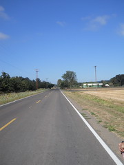
It was still overcast when we passed through Canby, but we started to see patches of blue sky around the time we passed Barlow Road, got patches of sunlight as we went across the Pudding River valley, and then by the time we reached 551 (by the Aurora Airport) the clouds had all evaporated except for one or two stray tendrils.
And then the headwinds started, and it started to get hot. We dealt with the headwinds in the traditional way of putting our heads down and sprinting into them (it does not work so well when you’re going upgrade, but it worked well enough so I could pull Kevin most of the way along North Valley Road to Flett Road before we turned sideways to the wind and I blew up) and dealt with the heat by trying to ignore it as long as possible.
Newberg (a little less than halfway with the extended route) was reached in 4h59, we reached Gaston a hour and change later, sat down for a 20 minute lunch, and started out again into a really hot sun. We couldn’t ignore it now, but continued to punch our way into the headwinds while starting to drink like fish to keep from evaporating completely away. The Gaston water ran out about the time we reached North Plains, so, after refilling, we tried to keep from drinking for the next 5 miles so that we’d have some water for the new Really Big Climb.
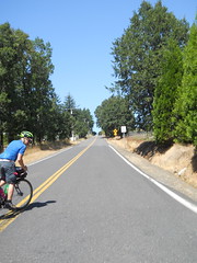
And, my, Logie Trail Road is a really big climb. It starts out super-steep, then moderates to merely steep, the bounces between steep and really steep for a few hundred vertical feet, then drops into a little valley and proceeds to rain down curses on you and four generations to follow by giving you first what feels like a Cole School Road-like ramp, which then moderates to a last mile to High Rock-like ramp, and then nastily bounces between those two for a considerable period of time before you do one last crawl through a logged over pine forest and are brought up to the intersection of Johnson (Logie Trail becomes Johnson Road for a while for no apparent reason) and Beck.
And did I mention it was hot while we climbed? It was so hot that the asphalt was slowly boiling, and there wasn’t much shade. This did merry hell to our climbing speed, and equally bad things to our water supply (which was vanishing at a rate of about 8 oz/mile.
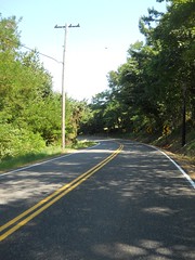
But at the intersection of Beck and Johnson/Logie Trail, Beck went downhill and through a wooded stretch, then tilted upwards only steeply and brought us up to Skyline without fuss, muss, or bother. Then there was 4 miles of descending to Cornelius Pass, often steeply, mainly done without brakes, and a refill of our completely empty water bottles before climbing up that last steep ramp, rollering along for a few miles, then plunging down to water level on Germantown.
We reached the bottom of Germantown without incident, then bolted south as fast as we could go for the final control. I’d moved the final control a mile north to try and make up for the extra miles that Logie Trail added, but the route was still 210km with those changes. We passed 200k in about 9h55, but then had to transit NW and downtown Portland with its approximately 1,000,000 stoplights, so didn’t actually make it into the final control until 10h25 after we left in the morning.
So not a catastrophe to be seen, but instead the fastest time I’ve done on this loop, even though the other times didn’t include Logie Trail Road, 95°F heat, or a boiling asphalt road. A third waterbottle would have made the loop nicer, but I never actually ran out of water even though I was down to the dregs at the bottom of the bottles by the time we finished Logie Trail.
So, all things considered, it was a good day out.
Pictures are on flickr and I’m now up to ~5400km of permanents/brevets (with another ~1200 of prerides and checkrides that don’t count. Drat!) and ~7000 miles ridden this year (I’m about 90 miles shy of 7k now, but I’m riding a donut populaire on Friday morning and that, plus a quick run sometime in the morning tomorrow, will put me over 7k miles (and 5500km of RUSA miles) for the year.)
Sadly, I won’t be able to keep up this routine of two permanents a week after the school year starts. Maybe I need to make some non-insanely-climby Portland-area populaires and see if I can ride them during the schoolday on Wednesdays?
Comments
I would ride the fuck out of that loop. Have you submitted it as a perm yet?
I’ve not. Maybe I’ll bombard Crista with 2 or 3 new ones before leaving town tomorrow.
Do it! Portland needs populaires!
Comments are closed
Not only is this non-insanely climby, it’s actually insanely non-climby
http://ridewithgps.com/routes/1529033
The “passes” are the two times over the 9th Powell overpass!