I feel the need, the need for speed
Summer vacation is basically at an end (next Tuesday the best starts her new teaching job, and on Wednesday the bears start their school semester) so I can no longer do the routine I’d developed this summer, which was to ride a 200k during the week, and then another 200k (or longer) on the weekend.
No, if I’m going to ride during the week I need to ride for 4 hours or less. And the only way I can do that is to ride a fast populaire instead of a full 200k loop. Fortunately my friend Kevin has been developing permanents left, right, and center, and had mocked up a fast flat 110k where the highest summit was the top of the pedestrian overpass at 8th & Powell. I strongly encouraged him to submit it (I believe my exact words were “do it! I’d ride the eff out of it!”) and he did, and it was approved the weekend of the summer 600.
This week, I mentioned that I’d be riding up to Ripplebrook and as part of my attempt to encourage other people to ride it with me I said I’d ride the now-approved Cuthbert Binns populaire on Sunday if he wanted to ride it then. I didn’t convince him to ride with me (I ended up riding it myself, thus giving me my first solo 200k of the month) but he thought that today (Sunday) would be a good time to do it.
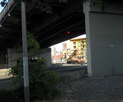
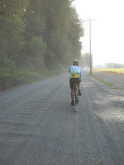
So, at 8am today I found myself back on the bicycle again, heading out for the wilds of Sauvie Island. Kevin had mentioned that one of the things he wanted to do with this loop was to get used to riding 18mph for long distances, and he was serious about it, because, after doing the initial segment along the Eastside Esplanade (and waiting for a train) we got onto Front Street and he wound right on up to that speed, which we stayed at for much of the next 40 miles.
It’s been several years since I was last on Sauvie Island (I believe the last time I went there was before the new bridge went in) and I’d never been there on a bicycle, so it was a nice day for sightseeing, though admittedly it was fairly high speed sightseeing.
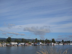
The route has two outandbacks on it; first it goes up the west side of the island on Sauvie Island Road (to approximately across from Scappoose,) and then it goes back down to the little town at the intersection of Sauvie Island Road and Reeder Road and takes Reeder Road all the way up to the nude beach on the northeast corner of the island.
I’d forgotten that the island was divided between Multnomah County and Columbia County, but was rudely reminded of it when, as we were sailing north along Sauvie Island Road at 19mph, we went over the county line and the nice smooth macadamed surface converted instantly to bumpy chip seal, with a corresponding reduction of my speed down to 15-16mph, so I had to hustle to keep up with Kevin and his chipseal-ignoring 650b wheels (I didn’t have much luck with 650b wheels on the mlcm, but I do fondly remember just how they dgaf when the road went to chipseal or gravel.) We stopped at the info control at the end of the road, and killed our brevet average a bit by snacking after I filled in the info question on my brevet card (Kevin, of course, had organizers privilege and didn’t have to do that) before turning back south and heading for Reeder Road.
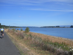
The Reeder Road leg of the loop is considerably longer than the Sauvie Island Road leg, and it took us across the island through farmland, a couple of tiny suburban hamlets, and finally north along the main channel of the Columbia River. Like before, the road converted to bumpy chipseal when we crossed the county line into Columbia County, but to make things even more amusing the road then went to gravel when we reached the parking area for the nude beach (and attached non-clothing-optional beach.) Kevin went sailing ahead while I slowed down and attempted to pick a line that didn’t hit every bit of washboard and/or leftover pavement (from the condition of the road I suspect that it used to be paved, but was then gravelled after a few spring floods washed out under the asphalt.)
Once again, the info control included a break for food, and then we turned around and headed south again. After the mile of gravel (again) and the long stretch of Columbia County chipseal, we went back into Multnomah County and smoother pavement for the rest of our time on the island. But instead of taking Reeder Road back all the way that we came, we turned onto Gilliham Road and looped around the southern edge of the island. It was later in the day, and many bicyclists were out on the road, mainly riding the other direction (if anyone was riding our way, we must have been keeping pace with them because we didn’t overhaul or were overhauled by anyone.
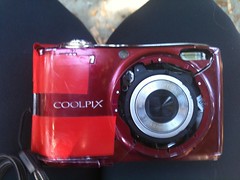
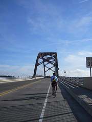
And then we were back to the Sauvie Island bridge and back to highway 30, which, ahem, is not quite as nice as the county roads. The shoulder of highway 30 is fairly debris-littered, and once you get closer to Portland it starts developing an amazing collection of potholes that we spent the trip back dodging. Unfortunately, about when we crossed under the St Johns bridge, I managed to avoid missing a pothole and bounced through it accompanied by a plasticky *clank* *CRASH* as my poor Nikon flew out of the rando bag and slammed face-first into the middle of highway 30.
*Sigh*
We arrested our forward progress, I ran back and picked up the camera (it wouldn’t power on because when it slammed into the highway the front and top panel bulged out and misaligned the power button. I discovered, after we got to the end of the loop, that if I squeezed the case together that the thing powers on without complaint, and takes pictures just like normal) and we headed out again.
Both the outbound and return segments take Front Ave down to/from Kittridge, which isn’t the most perfect route because there are a dozen railroad sidings that curve off from the old SP&S yard just west of Front. When you’re going north, the sidings have curved enough so that it’s not too difficult to turn and get a good perpendicular line across them, but when you’re going south you’re right next to the yard tracks and the sidings come in at a fairly acute angle. I’ve already had my wreck on railroad tracks and I don’t want to repeat it, so I slowed us down quite a bit by carefully weaving and cutting across the tracks at a somewhat slower speed than Kevin wanted to, but despite all that we still rolled over 100k in 3h55.
But then we got to downtown Portland and the Eastside Esplanade, which was no longer as quiet and empty as it had been earlier in the morning. It was crammed full of people and our previous headlong pace was reduced to a creep as we wound our way around joggers, walkers, other bicyclists, skateboards, roller skates, and heaven knows what else. It ended up taking us 27 minutes to get that last six miles into Brooklyn, thanks to the Eastside Esplanade, and we arrived at the end of the loop 4h22 after we set off.
Not bad as far as speed goes (our trip average speed was 15.5mph – comfortably faster than the 14.6mph trip average on my last ride to Ripplebrook) but not quite as fast as either of us wanted. And, my, when Kevin wants to maintain a high speed he’s a lot better than I am at doing it; when I’m cruising along at an average speed of 18mph, my speed varies all over the place from 21mph down to 16mph, but when he does it it looks like his speed varies from 17 to 19. I ended up drafting him for the entire loop because there was no way I could get ahead of him reliably (or even at all) and still maintain that pace. If we’d cut out stopping to food and routed away from the Eastside Esplanade we would have comfortably made the 110k in under 4 hours (at which point I would have fallen over dead; even at the somewhat relaxed speed we were going I still ended up with sore thigh muscles.)
Oh, yes, I think I’m going to ride the stuffing out of this loop this fall (assuming I can get suitable rainwear/cold weather wear so I don’t freeze.)
Pictures are in the same old place and this brings me up to 6700 RUSA kilometers for the year.
Comments
Comments are closed
Ah! Another hint that your Best is still alive in the world. A teaching job. Not much information there, but it is something. :)
Love to you all.