Well, this is going to make those 200km brevets seem fairly short.
Yesterday, thanks to the fortunate collusion of snow in the mountains last week, parental assistance in bear herding, and a bicycle that’s just a little bit faster than my trek, I was able to go out on an R300 and, as a radical change from the last time out on the line, actually finish the damned thing (in 17h30, which included a couple of hours of snaillike creeping through the (invisible, due to the dark) wine country of northern Oregon.)
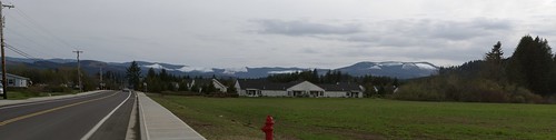
Alas, the Three Capes loop starts in Forest Grove, which is conveniently placed 24.5 miles away from home. So to ride on a brevet that starts at the UNGODLY hour of 6am, I need to be awake by 3:30 and out the door and on the way by no later than 4:00.
I’d spent part of Friday scouting out a route up to Barbur from the Sellwood bridge (the traditional “ride through the cemetery” route is not possible because the cemetery is now locked both top and bottom (and it’s not a particularly good route because it deposits you below the top of the hill at Terwilliger & Taylors Ferry, so you end up climbing a long way up, and then dropping down several hundred feet to get to Barbur)) – I’d looked at the map and thought that Macadam->Nebraska->Corbett (people who are familiar with this route are already snickering) would be a good way to do it, and it would if not for the pesky problem of a 20+% grade ramp that goes up most of the 2-300 feet from river level to I-5 level. Needless to say, this made it not a particularly suitable way to start a 215 mile bike ride, and I’d frantically pencilled in another route (Macadam -> Taylor’s Ferry -> La View Drive -> Corbett) before doing the final sewing chores on the saddlebag, boiling up a bag of potatoes as trail food, and recharging my GPS & cell phone for the deathmarch to follow.

Saturday (after a distressingly tiny amount of sleep, because I’d been working myself into a tizzy because of the evil West Hills) the alarm went off at 3:30, and I dressed myself, ate a cookie bar, and rolled out the door at 3:50. An encouraging note was found when I went up the Macadam->La View->Corbett route and discovered that except for a couple of short blocks at 20% the entire run up to the Brier Place bridge over I-5 wasn’t even 10%. I got to Barbur and Bertha at ~4:10, and reached Forest Grove at ~5:40, and then spent the next 20 minutes slowly freezing (it was 39°F at the Grand Lodge parking lot) before the bell rang at 6am
I don’t even try to pretend that I’m a fast rider, but I do try and keep up with the fast group as far as possible at the start of a loop, and yesterday was no exception; I clung to the end of the fast group for as long as it took to get out of Forest Grove and onto Stringtown Road, where an annoying headwind put a stop to that nonsense and left me labouring along while the fast group vanished as if they were shot out of a rocket.
And then, to add a touch of hilarity to the morning, I looked down at my GPS which was telling me that, despite my efforts the night before, that it was not charged and it would not be recording my itinerary on this particular loop.
*sigh* I’d prepared for the GPS running out of power by bringing along an external battery, but I hadn’t expected that I would have to use it 5 miles away from the start of the loop. But, anyway, there was nothing for me to do but grind to a stop, do the dance of electronic despair, and get the GPS plugged into the battery and running again (and it kept running for about 12 hours before dying the true death just north of Willamina) before I started up again and proceeded, alone, up to Gales Creek Road, highway 6, and the detour 5 miles up Timber road to an infostaffed control and back (I reached Timber Road just in time to see the fastest of the fast vanishing uphill on highway 6, and saw most of the rest of the fast group pass me by about 3 miles up the road. And that was the last I saw of most of them for the rest of the day. But I wasn’t the slowest of the lot, and there were at least a dozen people behind me that I saw running up towards the Timber control as I left and headed down to highway six.)
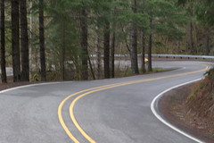
The control on Timber Road is conveniently located up past a pair of switchbacks where Timber road leaves the Gales Creek watershed and climbs up and over to the Nehalem River watershed. So it involved a short stomp up the hill, getting the cuesheet signed, then plunging back down the switchbacks and along the little side valley back to highway 6. Which was *cold* – by the time I reached highway six my fingers had, despite wearing two layers of gloves, frozen into little painful sticks which I was clamping into fists to keep warm and to devil with braking!
Scott Peterson (The randonneur who recovered me from Government Camp after I blew up on the Barlow 300) rolled into the Timber control on his recumbent just a few minutes after I did, and we rolled out at approximately the same time (which started a cat and mouse game that lasted for another 130 miles before he lost me for good.) Here I lost him going down the road towards highway 6, caught up to him on the long but gradual climb up to the highway six summit at ~1600 feet (the both of us puffing like steam locomotives in the cold morning air), lost him briefly on the downhill, and then, after he was stalled out by a flat tire, zoomed on ahead and didn’t see him again until the control in Tillamook.
The trip along the Wilson river from the highway 6 summit down to Tillamook is spectacularly beautiful, though I must admit that my admiration was tempered by first forgetting to wrap a scarf around my neck (one of the formerly shockingly pink woolen tubes that rivendell sells), and then, after stopping to see if Scott needed help with his recumbent, realizing that the Wilson River spends a lot of time right next to and a looong way down from the side of the road I was on. But nothing was quite so satisfying as when the Wilson River disgorged from the mountains and highway 6 popped out into the flatlands around Tillamook; I’ve seen it from a car a couple of dozen times, but there’s something extra nice about knowing I got there under my own force.
The segment from Forest Grove to Tillamook via Highway six is easily the fastest I’ve ridden 100km over a mountain range – 15mph moving average for the amount of time I had the GPS GPSing, 4h30 clock time (I’m not sure about the moving time, thanks to battery death), and being up 2h30 on the clock at the time I got my receipt at the Tillamook Safeway.
In the fantasy world where I could maintain this rate (and could avoid flat tires myself) this would work out to be a <14h brevet. Alas, this was not to be the case, because the roads along the Three Capes Scenic Loop are in what can only be charitably described as terrible shape, and soon after riding past (and unsuccessfully photographing) the cottage that we occasionally rent for holiday weekends, I slammed into a pothole that gave me a pinch flat on my rear tire (which I initially blamed on the nashbar tire letting a shard of stone through, but later investigation found a tiny little snakebite about half an inch away from the valve stem, so I think I must have hit the pothole so hard that the stem whipped down and fatally pinched the tire) which was complicated by my not reseating the tire properly, thus causing the bicycle to go *thumpTHUMPthumpTHUMPthumpTHUMP* every revolution of the rear wheel for the next 25 miles (despite trying to find the problem a mile away from the flat, and a couple of attempts to work the tire into proper seat at the top of Cape Lookout and in the control at Pacific City) until I finally pulled off the road, deflated the tire, and forced the tire into position by brute force and copious cursing.
In the grand scheme of things, none of the ascents of the three capes is particularly bad. But Cape Lookout (coming after a flat, the advent of *thumpTHUMPthumpTHUMP*, and the rest of the terrible roads on the Three Capes Scenic Loop) was quickly renamed Cape Doom, Cape Catastrophe, and various obscene names involving sexual congress and chainsaws as I tediously thumped my way to the top (to be caught again by Scott Peterson & his incredibly fast recumbent from scene 3.)
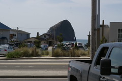
Pacific City is notable for several things. The haystack rock is one, of course, but it was also the point where my stomach started refusing to eat potatoes (thus resulting in a increasingly severe calorie shortage in the next hour or so’s worth of riding up to Sourgrass Summit,) and, finally, the previous tailwind turned around and became an annoying headwind for the next 20 miles along the coast and up along the Little Nestucca River. The headwind was annoying because I was trying to keep up with a recumbent (a doomed mission – those things are fast if given half a chance) and was so occupied with cursing the wind that I didn’t notice the “you are starting to {get hungry|feel weak}” warnings until the “You feel too weak from lack of food. --more--” message appeared and I ground to a stop (repeatedly) for picturetaking and application of emergency chocolate + potatoes.
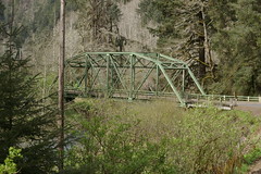
This is a good place for a picture. And food.
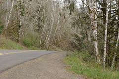
And this is a good place for a picture. And food.
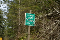
What a surprise! It’s a lovely place for a picture. And food.
(And there were also a couple of stops for just food, and one stop to deflate my rear tire, force the damned thing to seat properly, then reflate it. And food.)
And I finally crested the Coast Range (again) and went riding down Hebo Road towards Grand Ronde and the 60 mile crawl up through wine country back to Forest Grove.
The snaillike creep up to Sourgrass Summit gave me more than enough time to absorb enough food to shove me back up to a reasonable fascimile of operating condition, but the store at Grand Ronde was time to implement Operation Emergency Junk Food; I stocked up on candy, dried meat, and some horrible strawberry-kiwi “drink”, then headed off north in the company ofTed Lundin(?) & Scott Peterson (which rapidly became the company of Scott Peterson, because we had a tailwind and he was pushing as fast as he could go to get back to Forest Grove before it got too late.) I almost kept up with the super-fast recumbent, too (and this includes passing without photographing the W&GR railbus which is now parked as a display in front of the ex-W&GR depot in Willamina,) except that when we were almost at the info control at Ballston my rear tire decided, again, to go flat on me and I ground to a stop, cursing gently under my breath, as he vanished at line speed into the distance.
That flat would have been extra annoying because I’d only brought one spare inner tube, and the idea of sitting there gluing on a patch while the clock was ticking away towards darkness was, oddly, not particularly compelling, but while I was in the throes of unravelling the wheel Ted(?) rolled up, offered me a spare, and stuck around while I stuck everything back together (slowly, because for some odd reason I was kind of tired and every assembly step was a new experience for me.) And just down the road, at the Ballston info stop, Holden Hughart rolled up (to a chorus of “wait, weren’t you with the fast group?” (answer: yes, but he stopped for a meal)) and the three of us proceeded, mainly as a group (and accumulating other riders along the way,) all the way to North Valley Road, where my familiarity with the last 20 miles of the loop resulted in my pulling ahead and sailing off down the line well in advance of everyone else.
The sun went down about the time we reached Dayton, and, my, it’s spectacularly black out in the country when the sun goes down. If it wasn’t for the cloud cover (the weather forecast called for scattered showers in the evening, and there were scattered showers all right) reflecting the city lights of the greater Portland metropolitan area it would have been dark as my soul black. The 15 or so miles from Dayton to North Valley Road could have been in Australia for all I knew; it seemed like everywhere we turned was to the right, and I spent a good two hours clinging frantically to either Holden or Ted(?)’s wheel because if I’d gotten dropped I would have had to just stop and wait for the next group of randonneurs to happen along.

dramatic reenactment of me on a bicycle halfway between Dayton & North Valley Road
Basically, about all I can say in favor of the inky blackness that is the country at night is that I didn’t get to see the two or three steepish hills that always interrupt my runs up Spring Hill Road, and what I didn’t see kept me from dropping slower than my 70" gear on any of them. Not that I’d seek out riding in the dark, but it’s gratifying to be able to blow up hills without thinking (much) about it.
I think I’ve started to get my equipment list settled down to the point where everything works. I’ve tweaked the midlifecrisismobile so I can ride on it for hundreds of miles and have nothing hurt except my hands (I’ve not really found any padded cycling gloves that don’t make my fingers go numb, so I ride bare-handed and end up with stiff fingers) and my legs (because I’ve been pedalling for a large part of the ride.) The new saddlebag does an excellent job of moving clothing and other supplies I don’t need ready access to out of my handlebar bag (which, even though it’s still a prototype and needs work, is much happier when it’s not spending all of its time looking like a pufferfish that’s been stapled to the front of my bicycle.) I’ve got enough lights so I can mainly see where I’m going (except when there’s a lot of oncoming light – the D'lumotec Oval washes out just like that when a car doesn’t turn down its high beams), I’ve gotten my clothing stocklist down to the point where, at least when it’s not dumping down rain, I pack what I need and very little else (this time out the only piece of clothing that I didn’t wear were a pair of non-longjohn woolen underpants (I didn’t know just how hot it would be on the ocean, but it was no where near hot enough to make me want to shed layers off my container)) and with the space I’ve got left over it gives me enough room to pack enough fud to make it between widely separated controls for at least the first 200km of a ride.
What didn’t work was I didn’t bake up a fruitcake to bring along with the potatoes. After a while, I just didn’t want to eat potatoes anymore, but instead wanted something sweet right now. Fruitcake is sweet, and it’s a lot better for me than convenience store food.
And, even though I’m getting used to the feel of a loaded high trail fork, the disconcerting lunge the fork takes to the left or right when I get off the bicycle and try to find something to lean it against is not the most pleasant thing in the world. A long term solution is probably a low trail fork, but if I build up a rack I might be able to get my handlebar bag down a couple of inches and pushed back a couple of inches, which may improve the stability of the current configuration to the point where the front load doesn’t make it an offensive weapon.
When I was creeping slowly up the hill towards Sourgrass Summit, battling headwinds and a looming calorie deficiency, I was thinking that 300km was probably about all I’m capable of doing these days. 60 miles later, when I hit already-travelled territory and wound up to high speed for the 20 mile run into Forest Grove, the whole idea of doing something like a 400km loop seemed like not just a doable idea, but a downright sensible thing as well. (But not a 600km loop, because when I woke up this morning I needed to have a fairly long conversation with my legs before my thigh muscles would accept that they’re made for walking as well as lying in bed. I don’t know how gracefully I’d do this conversation if the brevet clock was ticking.)