Sellwood to Hood & Back, now available for extra credit
I rode it last year, with poor results, so I tweaked it and, after a long delay, rerode it last month, and then, after fixing a couple of routing misfeatures (like a 5-mile or so steep gravel descent on unmarked trails) I submitted it to RUSA as a nice little 300km permanent.
When I was in Bend on Sunday, I got mail that the route was approved, so the next time I ride the thing I can walk away with a little entry in the RUSA database of miles they approve of.
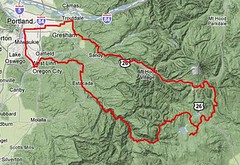
The executive summary for this loop is that you start out in the city, wind your way up to the top of the plateau between mounts Hood & Jefferson, and then after a considerable time sailing into and climbing out of various river valleys, you descend like a rock down into the Sandy River Valley, only interrupting the plunge to climb up Devil’s Backbone and then up the side of the Sandy River gorge before you work your way back into the city and back down to Sellwood (with a run up the shoulder of Mount Tabor as a last Hello, Sailor! before the loop is done.)
The features of this loop are a considerable amount of climbing (12,000 feet? 14,000? Only the GPS knows for sure, and it’s not telling,) primarily during the first half of the loop, and a really long stretch (from Ripplebrook to Government Camp) with no services except for water at Clackamas Lake Ranger Station (a good reason to plunk an info control there – after climbing up to High Rock your water bottles may be making gasping noises.) But you get excellent views from up on top of the hill; the road from High Rock across to Oregon Skyline Road gives you, if the weather is good, some spectacular views across the mountains towards Mount Jefferson, and when you reach NFD 48, almost every curve you make around a spur of the mountain gives you a larger and more spectacular view of the top of Mount Hood. And if you’re fast and can make it out of Government Camp before the freezing cold night winds start, it’s a shriekingly fast and spectacularly scenic descent down to Zigzag and the jog off to the Barlow Road for the run into Troutdale. There are pictures of it, too – 2010’s ride and 2011’s ride – so you can see some of what you’d be in for if you’re riding it.
And the route starts and stops in Westmoreland, instead of out in the middle of Washington County (I’ve already done the 26 mile shuttle out to the start of a R300 a couple of times, and it’s gotten really old. Riding around the corner to Marsee Baking to start the loop is a much more civilized distance.)
If you’re interested in riding it for RUSA credit, drop me a line; if you’re planning on riding when I’m around, I might be able to act as either an opening/closing control or, if I’m feeling fit and you’re feeling sociable, as a ride companion.