Next year’s project
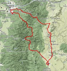
This loop is approximately the route my family took to get from Portland to Bend and back this last weekend. Some of the particulars have been tweaked – we drove out to Bend on highway 26, and didn’t take Marmot Road, the Barlow Road, Still Creek Road, or wind down into the desert on 217, the cross Warm Springs territory on BIA 3 – but it’s still the same sort of spectacularly scenic loop that I didn’t get nearly enough pictures of when I was wedged into the back seat of the car alongside two increasingly tired bears.
This loop carries the “long distance between controls or services” theme about as far as I’d comfortably want to carry them; it’s a long way between Zigzag and Warm Springs, and it’s almost as far between Sisters and Detroit (though there are probably some services in the form of a water tap at Santiam Junction.) And (assuming that Still Creek Road is actually passable) there’s a 7(8?) mile climb up Mount Hood on a gravel road, for people who thought that the narsty gravel ramp on the Oregon Coast 600 is just the thing for a nice day out.
If I can claw out enough time, I’d ride it as part of a short vacation; do Portland->Bend as one leg, rest a day, then come back over the mountain with freshly recharged camera and GPS, clean laundry, and fresh food. If not, well, next year is coming soon and I’ll be wanting to ride a 600 a couple of weeks after the spring series is finished.
Comments
Well, if you rode Still Creek Road a couple of years ago and it was torn up then, it’s probably no better now :-( I’m going to have to go out and ride it sometime, though, and who knows – perhaps the forest service ran a grader down the road between then and now.
If BIA 3 is crappy, would dropping down to 197 (and whatever backroads are necessary to work down to the Warm Springs agency) be better? I do want to push the route out into the high desert so people can get the full effect of it, and 26 doesn’t seem like it’s the best choice across the Warm Springs reservation.
Suttle lake has a store? That’s good to know; a place to get food and water is better than just a place to get water.
Still Creek Road wasn’t torn up, exactly. It was just surfaced with very coarse gravel, and not particularly evenly graded. It’s a beautiful road scenery-wise, don’t get me wrong. It’s well worth riding. It’s just not suitable for a rando or a perm, and will destroy your rims if you don’t have enough rubber on them.
As for the road through the Warm Springs Reservation, I’ve ridden it 5 times, and the surface varies from being moderately sucky chipseal to fairly decent, depending on how recently it was graded. The killer parts are the heat and the grades. I don’t think 197 is an improvement, though, as it’s got all of the heat and the grades, and adds traffic. Your plausible options are probably to go down 216 to Wapinitia and go south through the res, or you could go down 26 and cut over to Simnasho on BIA 9 and then south through the res, or just take 26 all the way to Warm Springs. 26 has a fair amount of traffic, and not really much shoulder (2' maybe), but it is flat and very fast. The second option might be a good one, as it cuts out a couple of hills (though it still has a couple nasty ones), and the section of 26 you’re on has a pretty good shoulder and is mostly downhill.
Comments are closed
Bill Alsup has asked me to design a similar route, actually. I’ll do it as 2 ~300k permanents.
A couple notes:
Between Zig Zag and Warm Springs there are services available in the form of a little grocery at Simnasho in the middle of the Warm Springs reservation.
That road through the res. is a complete fucking killer in either direction (c.f., the section at the Warm Springs River dubbed “Hellgate”.) Hot and steep and exposed and rough chip seal.
Services between Sisters and Detroit: store at Suttle Lake. Restaurant and campground with a spigot at Marion Forks. Nothing at Santiam Junction, though.
Still Creek road is a tough out. VERY rough gravel. I did it on a mountain bike a couple years ago. I wouldn’t even try it on less than 32mm tires, and would prefer 38’s, at like 55 psi.
Good call on going up out of Warm Springs through Pelton Park. At the top, go along the rim of the canyon above Cove Palisades, then Culver Highway to the Crooked River. Cross on US 97, then backroads from Terrebonne all the way to Bend.