Epic Fail
The plan was a nice loop up OR224 to Timothy Lake, then over Barlow Pass, back through Government Camp and (after a screaming descent down to about 10 miles east of Sandy) Sandy, then backroads across to Edgefield, followed by city streets to home. I’d ridden the first 50 miles of the loop a few times, so I knew that the start would verge on insanely hard, but then it would temper to a fairly moderate climb up to Ripplebrook, then a relentless stiff grade 2500 feet up the mountain to Timothy Lake, followed by roller(ish) riding over to Barlow Pass and (basically) all downwards from there. And, except for a handful of subdivisions around Oregon City and Gresham/Troutdale/east Portland, it would all be riding out in the country, even on the 30 miles of US26 from west of Barlow Pass to the middle of Sandy. And, judging from my performance (or lack thereof,) it would all be doable by everyone up to and including the slowest of the slow.
So I asked around for people to help me do a checkride on June 19th, and got nibbles from Ed Groth & Quang Vu Dang, who met me at the ung-dly hour of 5am and headed off for points east.
And, at least at the start of ride it was pretty much as I imagined; 17th & Milwaukie Ave are fairly urban, but pass by quickly, and then it’s a short wind along a bicycle path and back streets to the first (short but) steep climb on River Road, which then settles down to quietly rolling along all the way down to Oregon City, where we crept up the second steep climb to the top of the bluff, then headed south along Central Point Road until we fell off the Boring Lava at the edge of the urban growth boundary and headed down New Era Road on our way to the first control at Canby (interrupted only briefly by a stop when my cue sheet peeled off my handlebar bag and fell to the ground on the ramp down from the southern edge of Oregon city.) Past Canby, we headed east through a mix of woodlots & fields (there is suburban development around the edges of Canby, but not much, and by the time you cross the Oregon Pacific RR on Township you’re pretty much out of city until, um, you roll into Portland again.
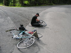
I ran into a piece of broken glass somewhere between Canby and Estacada, and got a slow leak in my rear tire that didn’t become noticable until we were about ¾ths of the way up the insanely steep ramp that is Buckner Creek Road, so we burned 25 minutes of our time as I s-l-o-w-l-y replaced the tube. But we still reached the pacing control at Estacada a hour up on the clock, so we were doing okay, and at that point we’d finished the steepest climbs (and over a third of the total climbing) of the loop, so it all looked good from that point on.
Until Ed got a flat on OR224. Followed by me running over a stone and getting my second flat of the day. 35 minutes stopped while we repaired the flats, and all the lovely spare time that we’d banked went right down the tube, so we reached (more or less) the top of the ramp on NFD 5810 with about as much time up on the clock as I had when I went up to Timothy Lake on my Trek, but that was okay (and the climb up was also as expected; it started with a speedy run up the scenic-despite-the-weather OR224, a slowish run up the last mile or so into Ripplebrook (where the store was open, and this time I found the water faucet thanks to Ed showing me where the thing actually was,) and then the expect slow creep up the relentlessly graded ramps on NFD57 (punctuated by level(ish) parts where we rode along, dodging the occasional newt & lizard, through a tree-lined corridor with small bits of sunshine peeking through the clouds) and NFD 5810.
The funny thing about NFD 5810 was that last year, even though I had a much smaller alpine gear (~30" instead of the ~40" on the MLCM,) it still seemed like a harder climb than it did on Saturday. It’s still a relentless grade (pitching up to 7% in places) and it goes on forever, but Ed & I spent some of the climb joking about how easy this was compared to the fresh horror that is Buckner Road.
And then we reached NFD 5820, and everything proceeded to fall apart.
I remembered NFD 5820 as being paved. It is not. It was, once upon a time (we kept seeing patches of pavement as we rolled along it) but it has been resurfaced with gravel. And it goes up 300 feet to ~4000 feet, drops down to Anvil Creek (but it’s not washed out here, unlike NFD 5810), climbs back up to ~4000 feet, then plunges, all gravelled, about 700 feet down to the junction with the other end of NFD 5810.
And while we crept along NFD 5820, we were having flats. About one flat per mile on this over 5 and a half miles of gravelled roads. After the fourth flat, I looked at our time (we were now deeply behind the clock to the tune of a hour and change into the Clackamas Lake Ranger Station) and suggested that we abandon and cut the loop short on US 26. No, no, the consensus was that we should continue up to Barlow Pass. And then we had a fifth flat, and as we sat there by the side of the road doing tube repair (Ed’s bike had the flat, but I was attempting to patch the two tires that I’d punctured earlier so that when we had the next flat, we’d have a tube at the ready) we looked at the time, looked at the road, said “f*ck it!”, and abandoned the brevet on the spot.
And then all we had to do was ride another ~80 miles to get back to Portland, and it was about 4pm.
NFD 57 & 42 were, as expected, rollery all the way up to US 26 (ascending ~400 feet in 22 miles) but US 26 had some unexpected surprises in the form of a collection of really nasty false flats (the summit of US 26 between the junction with NFD 42 and the junction with OR 35 is Blue Box Pass, at 4000+ feet, and we didn’t realize just how much climbing we had done before we got there until the summit signpost crept into view. And then after dropping off that point of land we dropped into a river valley and false-flatted our way up to the OR35 junction. The 350 feet of real climbing to get up above Government Camp was a relief compared to this because it was steep enough that we knew we were actually climbing.
And after a 45 minute hot food + coffee break in Government Camp (where the temperature dropped about 10 degrees while we were in the Huckleberry Inn eating) we threw on every layer of clothing we had and threw ourselves off the edge of the cliff for the screaming descent down US 26 to the river bottoms just east of Sandy.
I’m not sure just how fast I was going on the initial descent (because my GPS had run out of power a hour earlier, and I’d forgotten to bring a booster battery) but it was fast enough that the MLCM started to develop a nasty front wheel shimmy about halfway down. (Or maybe earlier, but I was shivering too hard then to notice.) But we were moving; it took us about a hour and 15 minutes to ride the 26-ish miles between the lower end of Government Camp Loop and the eastern edge of Sandy, and 3-4 miles of that were the climb up (in the DARK and in the RAIN, I may add) out of the Sandy River gorge at the end of the descent.
Needless to say, we did not loop over to Edgefield, but just followed 26 (in the DARK, but, thank goodness, the rain had stopped by then) all the way into Gresham, punctuated by one final flat, then hopped onto the Springwater Trail for the last dozen miles home (arriving at the stroke of midnight,) where I sat down, ate three meals, dumped my photos onto the computer, and slept the sleep of the dead for about 7 hours before I had to wake up and help pack and clean the house so the family could fly down to That Paradise That Is California™ for a vacation trip to Legoland. And when I finally got out on the line – for a short trip to get takeaway food for dinner – I found to my lack of surprise that my legs just didn’t have enough power to push me up hills at even my normal slothlike pace.
So I’m going to have to revise this 300 before I submit it as a permanent. The fast boys (particularly the fat tire bunch) would probably love it (or consider it a worthy challenge) as it stands, but the one flat per mile section of the ride (that’s at least 75 minutes burned up right there) makes it much less doable for the 17+ hour crowd. I know that I’d be fairly fretful about the whole idea of riding over 5.5 miles of tire-eating gravel, even if the Clackamas Lake Ranger Station is only a couple of miles of walking past that. I suppose that I could just change the loop to take NFD 58 up to High Rock, then NFD 58 and NFD 5890 back over to the point where NFD 5820 becomes paved – that only adds about 10 miles to that part of the loop, but on the other hand it adds another 700 or so feet of climbing on NFD 58, which apparently gets fairly steep(er) as it gets closer to High Rock. But if I do that, I’ll probably have to drop the Buckner Creek section of the Canby-Estacada leg, because having two sections of mind-destroying grades is not really compatible with my wanting to build a permanent that slower riders can do in finite time.
And I discovered one really annoying thing about US 26. It’s got rumble strips. And they’re placed on the shoulder side of the white line. And they aren’t visible when it’s wet and dark. And they aren’t continuous. And the shoulder isn’t reliably wide. So when it’s dark and raining, and you ride close to the white line so you don’t end up pitching down an embankment or into a drain, you will ride into one of them, and they’ll suck your wheels into them.
The first few times (of maybe 6 or 7 times) I hit the rumble strip I ended up being squirted out into the travel lane as I fought to get out of the velovibrotron without flipping the bicycle over in the process. If US 26 had been busy (instead of it being ~9:45pm on a Saturday night) this could have been unpleasant. Admittedly, this is not likely to be a problem for riders on a permanent (because I’m not going to make this one available in the short-dayed months, so the section on US 26 will happen during more daylightish hours if you’ve not already DNF or DQed out) but it makes the idea of routing along Marmont Road seem awfully appealing, despite there being a couple of extra-annoying climbs there.
In the category of things that worked vs. things that didn’t work, well, I’m not sure. NFD 5820 didn’t work in a fairly serious way, but it did provide a nice test road for the magnetic latch I was field testing. The 40" low gear was pretty painful when I was climbing Buckner Creek Road (but some of that was because the chain in the MLCM is worn to the point where it’s skipping), but I didn’t have to walk any of the ramps except when I walked up to a driveway to fix my first flat. I am fretful about the high speed shimmy that developed on the 2500' descent out of Government Camp, but all I need is $3-400 and a call to a framebuilder to get something with enough trail to fix that wagon (or I could just not descend long ramps quite so enthusiastically in the future.)
But, aside from that, it was a very nice loop, and all I need to do is correct the tire-eating part and it will make a nice 300km permanent that fulfills my desire of not having to ride 45km to get to the starting point. I’ll fix the routing and do it again later this summer, and maybe then I’ll be able to place the info controls before the sun goes down.
And I borrowed a camera, so there are pictures documenting the insanity.