Not waterproof, but that doesn’t really matter
It had been at least six weeks since I’d ridden a R200 (possibly 8 weeks; when I look back at my photos the last one I’d taken pictures on was the UGB200.bis loop I’d taken on September 4th) and I was starting to get fairly antsy about not having gone out for a very long walk for too long, so when Bill A put out a feeler for people to ride the Skyline-Vernonia permanent, I leapt at the chance to do it, nevermind the teeny detail that the weather forecast showed rain for the 13th of November.
Fortunately(?) it didn’t rain. Much. Lots of drizzle and the sort of extraordinarily wet fog that makes it seem like you’re in the middle of a very long refrigerated sauna, but not much rain.
I’d set my alarm clock for the ungodly hour of 5am on Saturday (the loop starts close for ORRando permanents, but it’s still ~12 miles away from home,) did a few last minute clothing swaps (long underwear instead of the knee-length underwear I’d set aside, knee-high stripy socks instead of the shorter socks I’d originally planned on wearing,) then rolled out of the house for the trip up to North Portland.
12 miles with other people around isn’t all that bad, even when it’s raining. 12 miles by myself in the rain gave me plenty of time to reflect on this being a fairly insane plan even by my admittedly relaxed standards. But despite this I still made it up to St. Johns before 7am (the official departure time) and squelched my way into the coffeeshop that was the official starting point for this loop, where I met up with Ed Groth, Adam George, and Bill’s friend Amy, who was there gathering evidence to help prove that randonneuring is dangerous to your mental health. And, after a few minutes break (where I purchased some sort of cheese+sausage breakfast roll) LynneF and Bill arrived, then the lot of us wandered out the door into the rain and rode off.
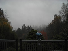
It drizzled most of the way into downtown Portland, then it stopped when we wound our way up to the (fog-covered) crest of Tualatin Mountain for an impressively slow grope northwards on Skyline Blvd. I’ve ridden the other way on Skyline at least a dozen times, and it never seemed all that long, but going north into a pea-soup (and rain-filled) fog was painfully slow; The five of us had stuck more-or-less together from St Johns to downtown, but once we’d become separated on Skyline it was as if we were the only people riding bicycles in the state. Lynne & I were traveling at about the same pace, so we whiled some of the time away grumbling about how Skyline felt like it was a really long haul when we were creeping through a tunnel in the mists.
We stopped at Skyline school for a brief snack (and regrouping; somehow Lynne & I had managed to get ahead of everyone else(!?!) and everyone else popped out of the fog while we were still wolfing down cookie bars and I was switching out my outer layer of gloves for a pair of plastic gloves (dishwashing gloves; we were about to drop down into the Tualatin river valley [~800 feet] and I didn’t want to freeze my hands in the process)) and then proceeded down Old Cornelius Pass at a moderate speed (everyone else just dropped, but I was fairly sodden by this point and didn’t want to risk freezing on the way down), turned onto Phillips, and then stomped on the gas to try and catch up with the Ed and Adam (and warm myself up) as they scooted across the valley floor towards Forest Grove.
By the time we reached Forest Grove, the parts of me that had not been previously soaked were now soaked from either sweat or drizzle, and the rubber gloves I was wearing were filled with water (the one problem of completely waterproof clothing; it keeps the moisture IN as well as OUT. Oh, well, at least I can use the gloves when I’m doing chores around the house!) and I squelched into the control there for a nice long pause for hot chocolate, half a cinnamon roll, and heat (as well as prying the now-wet leaves of my cuesheet apart and flipping it over to the Forest Grove->Portland side. The waterproofing of my cue sheet holder is not as waterproof as it should be, and the next handlebar bag is going to just have a way to clip a ziploc bag into place instead.)
Lynne showed up while I was tying up the mlcm; Bill showed up not more than 5 minute later. And we huddled inside for about 35 minutes before we were able to pry ourselves back outside for the second ramp up into the mountains (Lynne & Bill headed out first, then I headed out, and finally Ed and Adam, who then caught up with me about 2 blocks down the road) along Gales Creek Road.
It had been raining fairly happily while we were warming up in the control, but a band of not-rain came through just as we left. There actually was a brief moment on the run up Gales Creek where the clouds got thin enough so I could actually see shadows! Alas, this didn’t last, but it refrained from raining for the next 15 miles up the road, and the fog didn’t start settling back in until we were almost at Timber. (And by “we”, I mean “me”; I’d kept up with Ed, Adam, and Bill until Timber Road ramped steeply uphill, and then was (as is traditional) dropped like a stone.)
I “caught up” to Ed, Adam, and Bill at the summit of Timber Road; they’d spotted an dumped ATM (signed for a southern california bank) and were in the process of looking it over and trying to call the owning bank to see if they cared (they didn’t care. The customer support person on the phone basically told Adam that if he wanted the dead ATM, he could have it. I guess that’s the advantage of having your banking system unconditionally guaranteed by the government; lose a several-thousand-dollar ATM? No problem, the money spigots are wide open so it doesn’t matter if you spill a drop or two!) And while I was sitting there watching Ed & Adam look the thing over, up came Lynne – she’d stopped at the Glenwood Store and skillfully hidden her sweetpea, so we’d sailed right on by without even seeing her.
The ATM was a source of great fascination, but stopping was bad for the brevet clock, so first Lynne, then Bill, and finally I begged off and headed down the road towards Timber and beyond. I didn’t bother to stop in Timber to get a photo of the SD-9 which is still rotting away on the no-longer-used POTB mainline, but hopped off down the road towards Vernonia with visions of a proper lunch break dancing in my head. I was moving moderately quickly, so I managed to catch up to first Bill, and then after chatting with him for a while, to Lynne, and then after another 10 miles I pushed ahead over a couple of small climbs and ran on ahead into Vernonia, where we’d made plans to regroup at the Black Bear coffeeshop before heading on up the Scappoose-Vernonia highway to metropolitan Scappoose.
45 minutes later, we finally dragged ourselves to our feet, out the door, and onto the bicycles in an attempt to get over the Nehalem divide and into Scappoose BEFORE the sun went down (and we did. Barely. When it’s foggy the evening gloom comes on very quickly; we could still see some light in the sky when we reached highway 30, but it was gone by the time we turned onto Lane Road half a mile further on.)
And by then it had started to rain again, so our run up towards the summit was done in the wet. The Scappoose-Vernonia highway approaches the Nehalem divide in much the same way as Dairy Creek + Fern Flat Road approaches where Snooseville used to be, except the grades are ×2 as steep. Once you turn off 47, the Scappoose-Vernonia highway winds through a moderately open valley with an old railroad ROW visible on first the right side, then the left side of the road, and then the valley narrows and the road pitches steeply up for a twomileandchange grind up to the summit (apropos of nothing, I mentioned out loud that I thought the start of this ramp was about 8½ miles away from Snooseville – it turns out that I was wrong, because it’s only about 7½ miles away.) The five of us had stuck together up to this point, but as the grades got steeper I was progressively dropped by Adam & Ed, then Bill, and finally Lynne (who then stopped to wait for me to catch up before we rocketed down the other side of the divide into Scappoose.)
I reached the summit of the Nehalem divide at about 16:35; Lynne & I made the next 10 miles in 25 minutes, despite the road being more than moderately chewed up and landslidy near the summit. I think we passed Adam on the way down – I spotted a bicycle parked off on a side road that looked like a Trek Y-foil with blinkies – and we passed (but did not see) Bill, because he caught up with us just the other side of highway 30.
And then we had to loop out towards the Columbia River to get one last info control. Which was interesting – Dike Road, which, not surprisingly, runs along a dike alongside the Columbia, is amazingly rural once it gets dark. We were pinned between the Columbia River and Scappoose, but there was absolutely no sign of either of them while we were creeping along this road in the rain and the dark. We could have been in the middle of southern Illinois for all we could see. But we found the info control, and came to a consensus about what it actually was in the dark (it was on private property, so we didn’t want to go trapsing over to look at it with our bicycle lights. We’re pretty sure it wasn’t a B52. Or a rock lobster) and then looped back into Scappoose for a brief intermission at a gas station before heading back into Portland.
Scappoose is about 12 miles away from St Johns, which isn’t so bad on a sunny summer day. In the late fall, at 18:15pm, and in the rain (or fog, or drizzle), well, it’s not so good. The 4 of us (Ed caught up with us after what sounded like an extensive helping of bonus miles while trying to navigate around the Dike Road loop; Adam had apparently decided to head directly home?) headed south into the rain, but the combination of rain on eyeglasses and blinky taillights stretched us out into a long disgruntled line which didn’t properly clump together until we reached Portland and, more importantly, streetlights. Bill started slowing down about 5 miles out of St Johns because his rear tire was running low on air, but said that he’d rather ride it in than stop, so he waved us all ahead just before we reached the St Johns bridge, so Lynne, Ed, and I got to the end of the line about 3 minutes before he did.
And then, after a brief contemplative pause while we got receipts and a drink (or in my case, a veggie sandwich which was very good for the approximately 15 seconds it took for me to eat it) we dispersed and went our separate ways (Ed and I rode together down to Interstate & Denver, where he continued east and I turned south) and I rode the ~12 miles back to home, bringing me up to about 150 miles for the day.
Not very many pictures, alas, because I was wearing multiple glove layers and/or thick gloves (I can take pictures with my thin liner gloves, but don’t have the manual dexterity otherwise) for 99% of the loop, but plenty of wet to make up for it. The clothing I chose was all wool, except for my (allegedly) water-resistant jacket, my el-cheapo Nashbar +4s, and a pair of hastily put together reflective ankle bands (which got wet and disintegrated by the time we reached Vernonia. sigh) which meant that although I was completely wet I was completely warm (except for my toes and occasionally fingers) once I got moving (every time we stopped for any appreciable amount of time I’d be shivering to the point where the bicycle skittered over the road until I warmed up.) I’d been playing around with brake pads and had put a pair of Velo Orange “nonsqueal” pads on the mlcm last wednesday night – this was a horrible mistake to the point that if the ride had been any more bumpy than 5000(gps with elevation averaging)/7000(as described)/9500(gps without elevation averaging) feet I would have had to abandon because I couldn’t actually stop the bicycle on descents (all of the braking on the last 12 miles were from the rear brake, which had worn-to-a-nub koolstop black pads on it.)
Aside from that, the speed-sapping rain + fog, and the limbo-ish loop on Dike Road, it was a splendid ride. The only thing that went wrong is that I didn’t then go out on my bicycle yesterday, but instead spent the day cleaning the house, so my legs seized the opportunity to lock up on me last night.