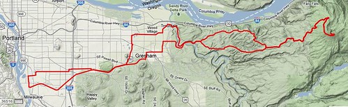
Permanent 1696 – No 1. The Larch. – 124 km
I can’t believe that this isn’t already registered as a RUSA permanent populaire, but when I browsed the list of Oregon permanent it didn’t show up. It’s really a simple outandback, with a few route tweaks for variety, and one substantial climb in the middle.
Larch Mountain is, at least when it’s not snowed in, a popular climb for fit road cyclists. The climb (~3900 feet from the Sandy River) is quite nice, climbing first through fields and villages, then up and through the Mount Hood National Forest and along the edge of the Portland watershed to a summit parking lot ~80 feet below the actual summit. It’s a pretty relentless climb; after you clear the lower plateau (where Springdale & Corbett sit) it goes up without a break basically all the way to the summit.
But first you’ve got to get there. This loop starts, as is traditional, at Bybee & Milwaukie (Marsee Baking is here, as is a Starbucks, a handful of restaurants and bars, and Staccato Gelato) and goes directly east on Bybee Blvd, which twists around the Eastmoreland golf course and becomes Woodstock before heading east towards i205. You take Woodstock for a considerable distance, but not all the way to i205 (where it merges, in a horrible mass of on and off lanes, with Foster Road) but only to 97th Ave, which has a bicycle/ped light where it crosses Foster.
Once cross Foster, the route works east on sidestreets for a while before it drops you onto the Springwater Trail for a 4 mile run out into Gresham, where you get back onto city streets to go north to Stark St, which you again take east to the Sandy River gorge and the start of the big climb. (Made a little bigger by, after you climb up to Springdale, being routed onto Hurlbert Road, and then Louden Road, which gets around the climb through Corbett by being an far steeper connection to upper Larch Mountain Road.)
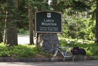
And then all you need to do is climb up to the summit and you’re more or less done with the climbing on this route.
The return is, obviously, on Larch Mountain Road (there are other roads coming off Larch Mountain Road, but they all go into the Portland watershed and are off-limit to non-permitted users because this is where Portland’s water supply comes from) but it doesn’t diverge back onto Louden Road, but takes Larch Mountain Road all the way down to the Historic Columbia River Highway, and takes that (with one shortcut on Bell Road, which is really steep and fast, but doesn’t have the best pavement; if you’re not confident in your abilities to handle steep potholed roads, staying on the Historic Columbia River Highway gets you to the exact same place as Bell Road does at the cost of maybe ½ kilometer) all the way down to the Sandy River gorge and, eventually, Troutdale.
In Troutdale, the Historic Columbia River Highway becomes Halsey Blvd, but you’re not going that way; there’s one more climb up 257th Ave into Gresham, where, after some wandering around on city streets, you eventually reach the Gresham-Fairview Trail, which you take south back to the Springwater Trail, then west on it all the way into Sellwood, where there’s a last mile of city street to return you to Milwaukie & Bybee.
Note that Larch Mountain Road closes during the winter, and is out of service from roughly November to June. So this is a summer/fall ride only (and I hope it gets approved soon so I can checkride it before the fall rains/snow starts … I’m not holding my breath, given that the long term weather forecast is showing “chance of rain” for what I hope will be next weekend’s 700, but it would be nice.)
Comments
Comments are closed
Not sure how else to contact you except via comment. Thanks for linking to my blog. Thanks for riding the eff out of your bike. That’s an admirable goal.