Permanent 1207 – Sellwood to Hood & Back – 301 km
Several years ago, I rode Michael Wolfe’s Barlow 300k which, aside from the tiny details of starting inconveniently in Sandy, a hikeabike across Anvil Creek (easier done with an xtracycle than with cleats!) and freezing my butt off descending from Barlow Pass, was a spectacularly scenic wander through the wilderness that I wanted to do again. Alas, the brevet wasn’t done again (until this year – the summer 400k this year was basically the Barlow 300k with the Maupin end filed down and a start in Portland rather than Sandy) and I wanted to get up into the mountains again, and maybe get RUSA credit for doing so.
After a few iterations and revisions I came up with a slightly different route that started in Portland and still got many of the scenic high points (and added a few new ones,) though I had to leave the leg down to Maupin out to keep the trip times down under 20 hours.
As you might expect, this route starts at Milwaukie & Bybee (most services start opening at 6am, but there’s a QFC and 7/11 a few blocks north and a Plaid Pantry 1 block south on Milwaukie) and works its way south on 17th, the Trolley Trail, and River Road down to Oregon City, at which point it heads eastward on the Clackamas River Road, Springwater Road, and Baker’s Ferry Road to Barton and a junction with OR 224, which you almost take all the way up to Ripplebrook Guard Station.

The almost is that there is a quieter and more scenic way to get from just north of Barton to Estacada. Just south of Barton is the junction with Amisegger Road, which takes you east to the backroads that you’ll be taking instead of 224. But first, some climbing; on Judd Road, you need to climb 300 feet or so up the side of a bluff on a moderately steep grade, and then wind upgrade for several miles between farms and what would be subdivisions if Oregon didn’t have fairly strict land use laws, then descend back into the valley and take Eagle Creek along the edge of a lower bluff all the way up to Estacada. But as you’re climbing up this bluff you might wonder why I didn’t route you along the slightly shorter and much noisier, busier, and glass fragment covered bike lane along 224.
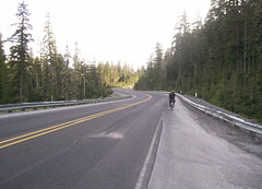
Well, there’s the small matter of the descent that makes this all worthwhile. The bluffs here are fairly steep and after you’ve transited Judd Road, crossed highway 211, and zigzagged over to Van Curen Road, you come up a small rise and there’s no road visible in front of you. Keep moving forward, because the road is there – it’s just going down really steeply to get you back down to the valley floor. I’ve made 50mph dropping down this hill without tucking, and even if you can’t get this speed it’s still an immensely thrilling feeling to drop over the edge of this cliff and see the road appear before you as your bicycle plunges down the ramp.
Eventually you reach the bottom, and eventually your speed reduces to the point where everything isn’t blue shifted, and then it’s a simple ride through more farms, ranches, and eventually a cluster of massive churches, as you ride up to the first (open) control in Estacada.

If your supplies are at all low, this is the place to top everything off, because south of here the pickings get very slim for the next 90 miles and you’re going to be doing a bucketload of climbing while you’re at it.
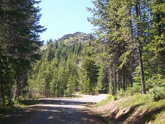
When you’re finished with this control, it’s time to head south to the next control at Ripplebrook Guard Station. Yes, you’re going to have to go back onto highway 224, but once you get south of Estacada you’re in the mountains and 224 becomes stunningly scenic. And, aside from two ramps (a long climb to get over a mountain spur adjacent to PG&E’s West Side Hydropower facility at Faraday Lake) and an almost as long climb to get up to the ledge that Ripplebrook sits on it’s all very sedately graded, with only a couple of spots where you’ll be suddenly struggling to keep up your speed until you realize that you’ve gone up a couple of hundred feet above the river and need to wait for the river to come up to meet the road again.
The control at Ripplebrook isn’t strictly necessary, but is more a not-particularly-gentle reminder that if you need more food and water you need to get it NOW because the real climbing is about to begin (9000 feet or so in the next 65 miles) and there are very few chances to top off your water supplies, and no chances to get more food, until all of this climbing is over. Fill your waterbottles here, and if it’s a hot day buy some bottled water to throw into your handlebar bag/trunk bag/jersey pocket, because the climbing starts almost immediately after leaving this control.
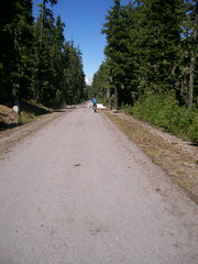
Highway 224 continues south for about half a mile past Ripplebrook, then comes to an abrupt end at a junction with NFD 46 (to Detroit) and NFD 57 (to Timothy Lake.) Turn onto NFD 57 and start climbing; you climb about 800 feet in the next 4 miles, and then give up about 400 feet in the two miles past that. The climb takes you up quite a ways onto the side of the valley of the Oak Grove fork of the Clackamas River, then drops you down next to it and hopscotches across it several times before you reach the junction of NFD 58 (and, coincidentally, the end of the paved part of NFD 57 – NFD 57 is paved up on the top of the plateau, but there’s 7 miles or so of gravel here including at least one steep loosely paved ramp.
No, your destiny is NFD 58, which climbs (and climbs, and CLIMBS) about 2000 feet up to the base of High Rock in the next 7 miles. It starts out steeply, moderates for a little while, then starts slowly pitching up again (not evenly; it pitches up, then moderates about halfway, then pitches up a little more severely until you’re climbing what feels like a 20% grade near the top) and goes on and on until you’re wondering if it will ever end.
And then you curve left and there High Rock is, looming over the last insanely steep section of the ramp. NFD 58 goes off 4 directions here, but fortunately only one of those directions is to the right, because that’s they way you want to go. This ramp is not quite done (there’s still 500 feet of climbing) but the grades are nowhere near as insane as they were just before this junction and you can get some spectacular views off to the south whenever the road passes through clear cuts. If it’s a clear day, you will be able to see Mount Jefferson off to the south, and there are a couple of spots where you can see Timothy Lake looking like a photograph 1000 feet or so below you before the road curves northwards and starts to descend.
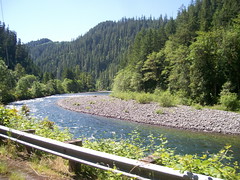
For a while you’re high enough to catch glimpses of Mount Hood peeking through the trees directly in front of you, but the road eventually turns back to the east and there’s not much to see except for miles and miles of forest with the occasional clearcut before you reach Skyline Road and a quick outandback 4 miles down to the Clackamas Lake Ranger Station, which, besides being a control, also has water (and maybe snacks; riders this year have reported that the visitor center there does have snacks for sale.)

When you’ve topped off your water, you turn around and head east again on Skyline Road, climbing past the campgrounds that circle Timothy Lake, into the territory of the Confederated Tribes of Warm Springs, and then to highway 26, which is a short but busy connection to the last and most scenic wilderness part of the loop.
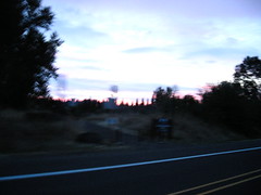
It starts with NFD 43 (Cedar Burn Road), which takes you six miles east to the White River, first rolling through open range (watch out for cattle grates) and logged over parcels, then dropping precipitously down into the White River Valley. You’ll pass a section of the old Barlow Trail here, but don’t take it because it’s not very well maintained and you might be unhappily surprised by a tangle of downed trees or a landslide, then cross onto the lahar flows that make up the floor of the valley, go over the White River itself, then run into the junction with NFD 48, which will take you most of the way up to Barlow Pass.
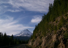
NFD 48 climbs basically all the way up to highway 35, sometimes steeply, but always relentlessly, but it climbs up the east side of the White River valley, which means that after a while almost every turn (assuming a sunny day) gives you another view of Mount Hood, each one more spectacularly sky-filling than the last. Eventually it gets so large that it ceases to be a mountain and becomes more of a snow-colored sky as you round the last curves and reach the junction of highway 35, which is only 7 miles away from Government Camp.
There’s a bit of climbing here, though. After crossing the White River for the last time, the road drops from about 4000 feet down into little valley, then climbs up to about 4200 feet to cross Barlow Pass, then drops about 700 feet to the junction with highway 26, and then climbs back to just barely over 4000 feet just east of Government Camp, where there’s another control so you can stop and get some food into you before heading back to Portland.
The six or so miles ahead are likely to be the coldest you will get on this trip. Highway 26 drops about 1800 feet down to Rhododendron, with most of the elevation given up in the first three miles. And in the evening and at night there’s always a cold wind blowing up the Zigzag River valley. So bundle up before heading out, and down you go.
I’ve come down this road in an automobile, so I know the views are pretty spectacular. But when I’m on my bicycle I’m too busy shivering to pay attention to anything except trying to keep from vibrating my bicycle into traffic or the ditch. But after you get down under about 2500 feet, it warms up and you can stop and delayer before you you reach another section where you have to pedal again.
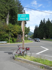
And that section is in Zigzag, where the route gets off highway 26 for a quieter run along the Barlow Road and Marmot Road. You duck north on Lolo Pass Road for about a mile, then turn back west onto Barlow Road, which takes you, mainly along the Sandy River, but occasionally swerving inland and running between vacation home developments, seven miles down the road to Marmot Road, which travels past vacation homes, woodland, and then ranch land, for about 4 miles before interrupting your forwards progress with a short, but insanely steep ramp up a bluff. This is a warning ramp, because another couple of miles brings you to Devil’s Backbone, which is climbed by a couple of almost equally steep, but much longer ramps (the first one zigzags up about 300 feet, then the road flattens out and runs through what’s left of the town of Marmot, and then another one which goes up about 400 feet, but without zigzags, and gets you up on top of Devils Backbone proper.)
If it’s still daylight, there are stretches along the road here where you can look left and see the hill sloping away from the road, then look right and see the same thing. Devil’s Backbone separates the Sandy River valley from the Bull Run River valley, and for some reason the settlers who originally made up the road decided that putting it over the top of Devil’s Backbone was the best way to do it. You’re done with the steep ramps, but the road keeps going uphill until it tops out at something over 1500 feet on a broad farm-covered part of Devil’s Backbone that local residents call Little Switzerland.
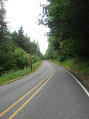
And then down you go again, dropping away from the farmlands and back into woodlands, then back into more farmlands on another broad plateau, then carving your way down to the Sandy River along a gently curving road that takes you down to the Sandy River and the last substantial climb of the day.
Here you cross the Sandy River and go up the side of the bluff – maybe 300 feet? – along a gently graded road that switchbacks up the bluff. At the top of this ramp you descend along Lusted Road for a couple of miles (it will likely be dark here, but you’re once again back in farmland and country houses) you’ll turn onto Dodge Park Boulevard, which takes you up another bluff, but on the old Mount Hood Railway ROW, so it’s not steeply graded at all.
You’re now about 25 miles out, but the hard part of the ride is done. Take Dodge Park Blvd into Orient, then 282nd/Troutdale Road north to the final transit control, and then you work your way into Portland on city streets, all either level or gently graded, with only one climb left as you climb over the shoulder of Mount Tabor on your way to the bicycle boulevard on Lincoln St. And at the end of Lincoln St you work your way through the maze of diagonal streets that is Ladd’s Addition, then turn onto 11th Ave and head south all the way back to Sellwood, where your ride is finished.
Pictures from earlier rides are here and here, you can look at the cuesheet, and you can contact me to ride this route for RUSA credit. Note that you need to take lights and the full complement of reflective gear that RUSA mandates, plus it would be a very good idea to take an additonal layer and windproof jacket along for the descent down from Government Camp, and if it’s at all hot you will need to carry three waterbottles.
Comments
The reason this route uses 224 all the way to Ripplebrook is that Faraday Road was landslid into oblivion not long after the Barlow 300, and after they patched it it got landslid into oblivion again soon thereafter. It was out of service for pretty much two and a half years, which neatly covered all of my various checkrides and submitting the route for approval (it was closed for the first two checkrides of Portland-Ripplebrook-Portland too, but it took me a long time to get around to actually submitting that route and before I got it submitted I heard that the road had opened, so that one I tweaked before submitting it. (And then when I did my first ride of it this year, allegedly a month and a half after the road was opened, it had just been opened and was a 5 mile scenic minefield.)
Yeah, it’s a hell of a climb and I was pretty happy to be able to not do it again. Changing the nonbrevet cuesheets is fairly low on my priority list these days, though.
If I was bike camping, I’d probably stick with 224 too.
I don’t think that the descent down Van Curin holds as much appeal to you because you’re too damn fast™ even on level ground, so you probably actually see redshift when you’re dropping down that hill :-)
I’ve gotta say, it does get annoying that my brevet times get capped out due to time dilation.
Comments are closed
Some comments:
I’m not as annoyed by the climb up Judd as I used to be; it’s not a tough climb, and it’s a pretty road. But I’m not as enamored of the descent on Van Curren as you are – give me a slacker grade with some nice curves in it every day of the week and twice on Sunday. On the whole, it’s probably a net positive over taking 224, though there can be something said for the later’s efficiency (especially on a bike camping trip up the Clackamas.)
This route takes 224 between Estacada and Promontory rather than Faraday Road? I like climbing as much as anyone, but you must be out of your mind. 224 in that stretch is at best unpleasant, while Faraday is sublime.
Regarding the Devil’s Backbone, the reason the Old Barlow Road goes up and over the ridge is that the wagons that it was designed for were very tippy and did not deal with orthogonal grades very well. So the roads took creek grades and floodplains, and when they couldn’t, the did things like winch themselves down the shute on the side of Laurel Hill, or directly up and over ridge backs.
I could be wrong, but I always thought Little Switzerland was the open pasture area just to the east of that first big climb up to Marmot, where if you are heading towards Hood, you get a rather Alpine vista of the fields, with the mountain in the background.