Permanent 1618 – The Wheatland Commuter – 207km
My Portland/Pacific City 160 populaire is a nice fast (if somewhat climby) way to get out of Portland and down to Pacific City, but it’s not quite so good coming back – the climb up to the summit of the Coast Range is a lot longer, plus you end up riding 30 miles on 99W during rush hour (finishing up with the Sellwood Bridge also at rush hour, which is an extraordinarily unpleasant experience.) So when I was making the routes to Pacific City, I made a different one for the return trip.
This route starts where the Portland/Pacific City 160 left you; at the Pacific Ave bridge over the Nestucca River. But instead of heading towards the Nestucca River Road, it follows the route that orrando’s Three Capes 300k uses to get from Pacific City back into the Willamette Valley; south on Brooten Road to highway 101, then east on the Little Nestucca River Road.
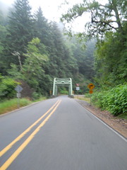
The Little Nestucca River Road is a very pretty route, but for the purposes of this brevet the prettiness is not quite as important as where how you go over the summit of the Coast Range. Here you go over Sourgrass Summit, which is at 572 feet (and it takes about 15 miles to get there from highway 101) and the approach to it is almost uniformly gentle – there are a couple of short steep ramps that might make you want to drop to an alpine gear, but the rest of the climb can be taken in your big ring at a good pace. Alas, it being a low summit doesn’t give you much of an opportunity to go rocketing downhill, but the highway (The Little Nestucca River Road joins Hebo Road about 5(?) miles west of Sourgrass Summit) gets sketchy when you get close to Grande Ronde (it’s been grooved in preparation for repaving, but in the last 3 years only about a tenth of it has actually been replaced) and is not particularly good for zooming right along.
When you reach Grand Ronde, the route cuts over to highway 18, passing by a general store at the intersection of Grande Ronde Road and highway 18 (more useful later in a longer brevet, but if you really need supplies this is a good place to get them) and then heads west along highway 18 for a while.
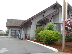
Highway 18 is a kind of grim route, but it’s the only way past the Confederated Tribes' casino, and not too far past there you need to get off the highway and onto the Yamhill River Road. The problem is that the Yamhill River Road is no longer connected to highway 18, so you have to hop off your bicycle and walk it down a 50 yard path past the barriers at the end of the Yamhill River Road. And then you continue east on a basically deserted residential road until it swings north, intersects highway 18, and becomes business 18 for the ride northeast(ish) to the first control in Sheridan.
Once you’ve finished in Sheridan, it’s time to head east again. Bridge Road (the main drag in this small town) becomes Ballston Road, runs south out of town, then turns east and a little north along the railroad line through Ballston and beyond, eventually becoming Broadmead Road before merging into highway 153, which drops you into Amity, which is where you bid farewell to the Three Capes 300k route and head off to the east.
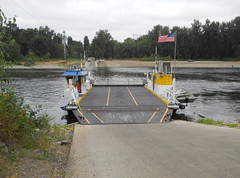
East of Amity, highway 153 climbs through a low pass in the Eola Hills, then merges onto highway 154 for a six mile run down to the junction with highway 221, which you stay on for maybe a mile before turning east again onto Wheatland Road, which takes you to the tiny village of Wheatland and, more importantly, the Wheatland Ferry, which takes you out of the relatively hilly western part of the route and onto 20-odd miles of flat farmland as you head east across the prairies to the foothills of the Cascades.
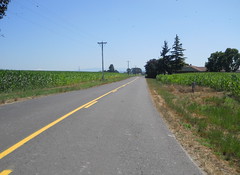
As you travel you’ll pass through Gervais, Mount Angel, and finally Marquam (though don’t blink here, because there’s not very much to Marquam except for a pub at the junction of highway 213 and Knowlens Bridge Road) so you’ll have plenty of opportunities to stop for a snack as you go. And then you run out of prairie – just east of highway 213 the route turns onto Wildcat Road, which enthusiastically climbs up onto the foothills of the cascades in a series of steep ramps, steep plunges into small river valleys, then steeper ramps that climb out of those valleys. It’s quite pretty here; it’s not terribly wooded (a feature that you might curse on a sunny day) but the road travels through small farms, orchards, ranches, and the occasional cluster of country houses. And eventually you reach the summit (at the junction of Wildcat Road and Fox Road) and immediately plunge down out of the foothills towards the next control at Molalla.
From Molalla, you go north and west on back country roads south of the Molalla River, then north on highway 170 into the final transit control in Canby, and from there it’s up onto the Boring Lava to go north on Central Point Road, then dropping down off the Lava, then dodging over to Leland Road to climb back up it again. And then, after working your way through Oregon City, you find youself back on River Road, then the Trolley Trail, then River Road, and then the Trolley Trail again as you head towards Sellwood.
A quick run up 17th Ave (the traffic signals at 17th/Harrison/99e are not designed for pedestrians or bikes, so you might find yourself better off just taking the sidewalk up 17th to the intersection with Lava Drive, then dropping back onto the street for the rest of the way and you find yourself at the final control at Milwaukie & Bybee in Sellwood. There are plenty of services here; 3-4 bars, a handful of restaurants, convenience stores north and south on Milwaukie, and a grocery store (QFC) three blocks north. So you’ll be in good shape to get your card signed, then have a chance to sit down, have a drink, and plot your next trip to the coast and back.
Pictures from my checkride are on flickr, you can look at the cuesheet, and you can contact me to ride this route for RUSA credit.