A little more adventure than I expected, but that’s not a bad thing
My plans for after the summer 400k were to immediately get on the bicycle and head west for a week at the coast. And after doing it in a much more inelegant manner than I wanted, I needed to do a loop by myself without distractions. Fortunately my Portland-Pacific City 160 had been approved last week, so I could kill multiple birds with one stone here. And it uses Nestucca River Road, which means that there will be about 4000 feet of climbing which I could possibly do without being as embarrassingly slow as I ended up being on the Barlow 400.
It turned out to be more adventurous than I thought, but I still clocked in a less embarrassing brevet average despite everything.
But where to start? My original plan was to come back from the summer 400k and head for Pacific City, but the best put her foot down and said “no” when I woke up from my 2 hour nap (which was enough to keep me within hypothetical brevet minimums for a 600k) so I had to defer it until Monday. And on Monday morning, after the alarm clock woke me up at 4am and I realized that I had about 2 hours of chores to do before I could go out, I decided that I would much rather avoid the morning rush hour and leave at 9am, so I went back to bed for a couple of hours, woke up at 6am, did my chores, and was well on track for a 9am departure until I checked the mail and found a new Berthoud saddle sitting in my mailbox, which pushed my departure time back to almost 10am.
At 10am, there is considerably more traffic than there is at 5am, and so 99W is less appealing. But it has bike lanes most of the way out to Lafayette, and the traffic outside of rush hour is tolerable. So I got over the Sellwood bridge (sprinting upgrade at 24mph to keep ahead of traffic; I slowed down on the downgrade because the pavement is not so nice on the west side of that bridge and I’d hate to crash and put myself into the hospital just before my birthday) and up to Barbur (via the traditional Taylors Ferry/LaView/Corbett route, which isn’t nearly as steep as any of the alternatives) in good time, and was maintaining a brevet average of about 15mph as I sailed south to Tigard, where, just as I was climbing the north side of Bull Mountain, the mlcm rolled over a staple that punctured the rear tire and slowed me right down.
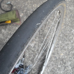
It wasn’t so much the puncture that slowed me down (it took a leisurely 15 minutes to change the tire, but I wasn’t in a hurry until afterwards, when I looked at the GPS and saw that my brevet average was down to 9.4mph,) but the realization that I’d used up my last patch when the old Clement Strada tires got a flat on the return from Ripplebrook on my <9hr loop a few months ago. So I swapped out the inner tube for my spare, then gingerly proceeded towards Pacific City while keeping a sharp eye out for an open bicycle shop. (Monday is a religious holiday for Portland-area bicycle shops, and I had to go all the way to Newberg before finding an open shop where I could buy another patchkit and inner tube.)
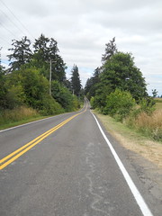
South of Newberg, as you may not know, 99W becomes gradually more and more rural, and by the time you reach Lafayette it’s not much more than a busy secondary road. But the roads are about to get much nicer, because after you pass through Lafayette you go over a bridge, then turn off onto Mineral Springs Road, which is the first of many miles of narrow scenic country roads with minimal traffic. You go north on Mineral Springs Road for a handful of miles, then turn west on Hendricks Road towards Carlton and points west.
Carlton is a fairly small town, but it does have at least one market on Main St (Hendricks Road becomes Main St in Carlton) which you need to stop at and stock up on water and food (if needed), because once you leave Carlton, it’s 45 miles and several thousand feet of mountain climbing before the next chance to get water. I was paranoid here, and not only filled my two water bottles but picked up a third bottle and stuffed it into my jersey pocket just in case.
West of Carlton Main St becomes Meadow Lake Road, which rolls along for a few miles (including a couple of whopper climbs that made me think the Coast Range had crept up on me before they pointed down) through farms and ranches, then tips up and climbs up about 1700 feet before tipping downwards for the run to the coast.
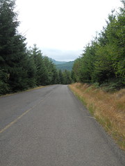
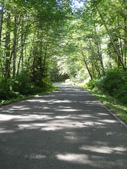
It’s quite a climb. You climb steeply for a few miles, then the road flattens out on a saddle as if it was about to summit, then it laughs and goes up steeply again (three times in all) before eventually becoming Nestucca River Road (after a 2 mile stretch of a poorly paved logging road) and going up again to a rollery stretch at ~2000 feet that skirts the McMinnville water supply before finally tipping downwards and heading for the coast. And all of this travels through a designated wilderness area, so it’s stunningly beautiful.
But I found some extra adventure on the way down towards the coast – up on the east side of the mountain, at the point where Meadow Lake Road becomes Nestucca River Road, there’s a BLM display noting the natural beauty of the area, and stapled to the frame of the display are several notices regarding things like burn restrictions, hunting restrictions, and a note that the Nestucca River Road was closed for construction and you needed to detour – via Bald Mountain Road and Bible Creek Road – around a 14 mile stretch of Nestucca River Road.
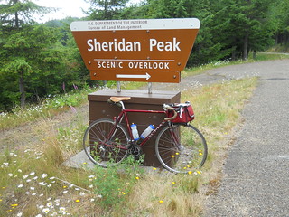
On paper, it didn’t look that bad (except for the “Bald Mountain Road” name of the road) but when I reached the actual detour the detour sign pointed to this road that appeared to be painted on the side of the mountain. And that’s because Bald Mountain Road climbs up to the summit of Sheridan Peak, which is 2600 (or 2800 feet; my GPS and ridewithgps.com both claim that I stopped out at 2800) feet ASL. And the foot of the detour is at 1600 feet, and you need to pay off that 1000 feet in three miles. So up I went, on an almost completely deserted mountain road. After a quarter mile, I passed a pulloff and fired up the music player on my cellphone, put in one earplug, and started playing my Crush Therapy collection on a random loop to help encourage me to climb faster.
It worked, and I managed to maintain about 7mph (as opposed to the 5mph I was doing without a soundtrack) for the rest of the climb up to the summit of Sheridan Peak, where I stopped, got a picture, then looked at the steep descent and decided that this might be a good time to layer up (my cloud-chamber jersey was completely soaked with sweat, and it was still cloudy, so not having a windbreaker here seemed like it would be an excellent chance for summertime hypothermia.)
And then down I went – Nestucca River Road descends about 1200 feet on the closed section, but I’d gone up 1000 feet so I had a 2200 foot descent. And it was a marvelous descent, because there was no traffic on the road, the road surface was in excellent shape, and there were good sightlines on almost every corner. And the Berthoud saddle has enough extra setback so I could drop into a nice low aero tuck and go screaming down the curvy road like there was no tomorrow.
In unlogged country, too. The BLM has set this area up as a ATV playground, so ATV singletrack is threaded around the road, but since it was monday nobody was out playing on it. So it was just me, my music, and the howl of a 30-40mph descent for 30 minutes or so and I swept around corners and switchbacks as if I actually knew what I was doing.
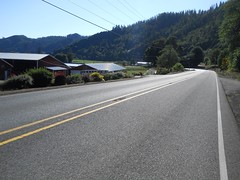
And then I got squirted out onto the Nestucca River Road again, which went another 25 miles before it dumped me onto highway 101 at Beaver. But that 25 miles was no waste – sure, I couldn’t go at freefall speed, but the road first wanders along the Nestucca River in the designated wilderness area, then along the Nestucca River past more farms and ranches, and then, briefly, through the town of Beaver before it dumps you onto highway 101.
And there I had my second adventure – my cuesheet told me to go R on 101, then L on Sandlake, but I read it as L on 101 and didn’t realize my mistake until I was 4 miles offcourse. Ugh. I should have realized that I was going the wrong way earlier, because 101 north of Beaver has wide-enough bike lanes along the road, but south of Beaver has maybe a centimeter between the white line and, often, 3 foot deep drainage ditches. And 101 was pretty narrow here, so all of the logging and livestock trucks when whipping on by about a centimeter away from me (to match the “bike lanes” on this stretch.)
But eventually I realized my mistake and turned around to work my way north (against a stiff headwind) up to Sandlake Road, where I turned west and was able to reap the benefits of a nice stiff tailwind all the way into Pacific City. 12 miles of 20-25 mile an hour cruising? Yes, please, and thank you!
I arrived at the final control just after 7pm (which is about when I was predicting when I called to say I was running late) having ridden 114 miles (and climbing something over 6000 feet) in 9h17.
I’m not so sure how nice the route would be in reverse (even though it is reversable) because the climbs there are more gradual, which means you’ll spend more time grinding out the miles and less time plunging like a stone from the heights (and then there’s that pesky 99W runout into Portland) but it’s a spectacular route going outbound.
Things that worked and didn’t work?
The Berthoud saddle worked and didn’t work; it feels nice and comfortable out of the box, plus the rails are designed to allow a little bit of extra setback, which is one thing I pretty desperately need on the mlcm. It didn’t work in two ways; the first is that it’s not broken in yet, and my seatbones started to complain afer 105 miles, and the second is that the setback is now so long that my legs are rubbing against the toolroll I’ve got tied to the saddle.
The Shimano cleats are still a work in progress. I’m having more trouble with the right shoe than the left, and am moving the cleats around to get them to fit right, but until then I need ot put up with my right foot cramping on sustained climbs :-(
Comments
Comments are closed
The klick-fix attachment on the Berthoud saddles works pretty well; the seat bag (at least the one I’ve got tube+tire levers for the Rickshaw) is dead aft, and out of the way. Never noticed it’s there when pedaling. This does have the disadvantage of having to purchase the attachment and a bag that uses it.
Glad the saddle mostly worked for sitting-upon purposes!
I’ve found with mine that checking the bolts that attach the leather to the frame is a good habit; they come with blue locktight on them, but enough rumbly ridding on gravel can loosen them up a bit.