There and back again (part 2)
After I rode down to Newport for the last-minute vacation last week, I found myself at the end of the week needing to get back into town. I needed to come back on Friday, too, because I was going to staff (and try to run sweep for, but that didn’t work out) the summer 300k on Saturday.
So on Thursday evening I ziptied the broken rack, then loaded up the midlifecrisismobile with what I needed for the ride back. And Friday morning (at ~4am) I woke up, ate a little breakfast, then rolled out the door into the bitingly cold (~50 degrees) predawn light.
Newport was completely deserted, so I was able to shiver my way through town and onto Yaquina Bay Road without any fuss, muss, or bother. And, as I suspected, the biting cold relented when I got about 4 miles away from the coast and out of the marine layer (it was 51 degrees in Newport, 61 degrees 50 minutes away in Toledo) so I was able to strip off one layer of clothing before heading north on 219 towards Siletz.
The Siletz River sits higher in its valley than the Yaquina River sits, so climbing over the divide on 219 is a more substantial process than it is the other way, but it was still early in the morning so the climbing didn’t bother me that much.
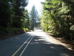
And then into Siletz (over a just repaved bridge over the Siletz River) and onto Logsden Road for the long climb up into the mountains following the river. This climb was much like last year’s Oregon Coast 600 climb (modulo riding with other people, of course :-() and the miles rolled under the wheels of the mlcm much faster than they felt on the way down. It was a weekday, so there was not much traffic, and the bulk of that traffic was logging trucks, which were almost universally very considerate about moving well out of the way of the solitary bicyclist.
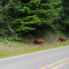
When you get about 8 miles east of Logsden, Logsden Road runs through a stretch of open range, marked with sedate official highway signs and more truculent home made “YOU HIT YOU PAY” signs. I’d not actually seen any cattle on this open range before, but this morning I rolled through a large herd of them – one very large bull and a dozen or so cows – who stared at me with great interest as I rolled slowly through their midst and said hello in a very calm and sedate voice. And soon after that, I fell off the edge of the pavement and onto the gravel section, which I made quick work of this time because I could climb the hardpack on the (steeper) west side without getting off the bicycle. I did have to stop about halfway down the east side to stretch my arms, which were starting to cramp from braking (I am afraid that Ruffy Tuffy tires, which are quite nice on good pavement, are just about exactly the wrong tire for gravel and sketchy pavement – they are wide enough to float on loose gravel instead of digging in, but aren’t wide enough to bridge multiple chunks of gravel, so they end up rolling the top layer of stones as they skitter sideways. This made descending the east side of the Logsden gravel a little more exciting than I wanted, and probably will convince me to either deconvert the mlcm (back to 650b like it originally was) or go back to 25mm tires like the short-lived Clement ones I was using this spring.)
Even though I had left the marine layer far behind, it was still cloudy (and drizzling a little bit where Logsden Road squoze up against the northern side of the Little Rock Creek valley) as I worked my way up to the east end of Logsden Road and turned to climb the long ramp up towards Summit (and, eventually, Blodgett.) But after I worked my way up to the top of the ramp (a task that seemed much easier than it was last year) I climbed past the edge of the cloudcover and into an absolutely sunny day.
I reached the Blodgett Store around 4 hours after I departed Newport, and that was a little early in the day to have an ice cream cone. So I had a milkshake (and jalapeño poppers) instead, and then after a somewhat shorter break (20 minutes instead of a hour :-) I headed east towards Kings Valley Road.
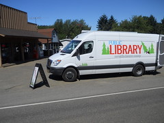
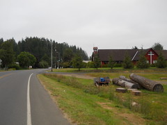
When I turned onto the Kings Valley Highway a bookmobile came whizzing by me, but when I approached the Kings Valley store I saw it sitting out in front, open for business. I didn’t stop there (no library card for that library system) but when I reached the Ritner Creek covered bridge (moved sideways to sit between the highway and the long-demised Valley & Siletz mainline) I did stop to get pictures of the mlcm on the railroad ROW and in front of the bridge before hopping back onto the bike and heading north towards Dallas.
In Dallas, I refilled my water bottles (this time I’d remembered the Nuun nasty sports drink tablets, so I didn’t have to buy premade nasty sports drink) and stopped for a piece of fruitcake and chocolate milk. I stopped again in Dayton to refill water bottles, but that was the last stop I made until I got into the Portland area.
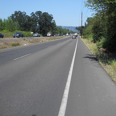
The stretch from Dayton to Newberg on 99W was not much of a pain at all; the early friday rush hour was starting to jam up the southbound lanes (particularly in Dundee) but there wasn’t much traffic going north and the bikelanes were generally wide, clean, and in good repair. North of Newberg saw rumble strips appearing along the road for the climb up Rex Hill, but there was enough bikelane outbound of the rumble strips to not have to worry about accidentally riding into them and being sucked out into the traffic lanes (highway 26 east of Sandy is really bad in this regard; the bike lanes are narrow on the climb out of the Sandy River gorge, don’t have striping, and have the rumble strips set well into them. When I did my first checkride of Sellwood to Hood & Back I had routed it on 26 through here, and that one ride was enough for me to push all of my alpine routes over onto the less trafficked but way steeper Marmot Road) and in any case the rumble strips vanished when I reached Sherwood and I was left on acceptable bikelanes for the run into town.
Unfortunately this happy situation came to an abrupt end when I reached Tigard, where the highway department had decided that putting bikelanes on the long climb up to the top of Tualatin Mountain was a bad idea, as was keeping wide lanes on the road. So 99W became much narrower, the bike lanes went away, and I though “oh, to devil with it!” and hopped up onto the sidewalk for the last long climb of the day.
The rest of the trip (the last 8 miles) were not the most pleasant thing in the world; the bike lanes came back after I reached the Portland city limits, but Barbur at rush hour is a much less pleasant experience. And when I reached Taylor’s Ferry Road I ran headon into the horrible Sellwood Bridge 2-way rush hour, which is going to be a permanent fixture of this loop until the replacement bridge is built sometime in the next 3-4 years.
And then over the bridge, up Tacoma to 13th, 13th to Bybee, Bybee to 17th, finally arriving home 11h58 after I’d set out in the morning.
The same things worked and didn’t work this time around, but at least I ended up at home, so I could rip the Eggbeaters off the mlcm and replace them with the pair that were on the Trek (I need to get new pedals for the Trek now; perhaps I’ll just put flat pedals on on everything except the mlcm until I can find clipless pedals that actually work.)
I was hoping to do the loop in less than 11 hours, but just couldn’t find that additional oompf to do it. Oh well, maybe the next time we’re invited down to Newport.
Pictures can be found on flickr.