Revisiting the CZ haul road, a year and a half later
Last Tuesday, Ed Groth proposed a Saturday group ride out to Vernonia via the (ex-)CZ haul road and other logging roads, returning via the (ex-)United Traction line from Vernonia to Banks, then taking a collection of secondary roads back into Portland.
I thought it was a smashing idea, despite the “cross bike or 28mm+ tires recommended” note on the mail (not that I was going to pay any attention to this recommendation, because there’s no way I’m going to fit wide tires under MLCM’s fenders – I have a pair of el-cheapo wide Velo Orange fenders that I’m going to stuff under that bicycle sooner or later, but this is not the month for that – and furthermore I’d ridden the CZ haul road, plus the still-unpaved-at-that-time sections of the United Traction ROW on the same kind of Nashbar 26mm tires that are currently on the MLCM. So I set my alarm clock for 5:30, then woke up and staggered around like a clubbed ox for a hour before getting out the door, arriving at the designated departure point in North Portland at ~7:15.
It was all dark and silent. Uh oh. Maybe they left already?
I sat around for a few minutes trying to decide what to do, then bolted off towards Scappoose as fast as I could go in the hopes that I’d catch up with the group before they rolled into Scappoose. But despite sprinting up to Scappoose as fast as I could go (The Hood to Coast relay race had gone this way on Friday, and there was an amazing clutter of shattered blinky lights, earphones, and waterbottles along the side of the road, most of which I managed to resist stopping to pick up) I didn’t see anyone I knew, so I made what was probably a fatal mistake – I thought that maybe I was wrong and started before them, so I should park myself at the foot of the CZ haul road and wait for people to catch up to me.
Half an hour later, I reconsidered this decision, and thought that I should maybe return to Portland and make other plans. But I’d come this far, the Black Bear Coffee Company is always a good place to stop for a snack, and it would be much easier to piece together a 70 mile return (to round up to a R200) from there than it would be to make a 70 mile loop from Portland. So I hopped back on the MLCM and headed west on the CZ haul road.
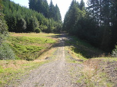
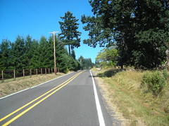
There’s more signage along the haul road these days, and it looks like Columbia County (or one of the trail-maintaining groups in the Scappoose area) have run a mower down the lower reaches of the road, but it’s not in any better condition than it was last year. But at least it’s been dry for a few weeks this year, so the steep ramps up to the summit aren’t quite as slippery as they were. And the second washout on the east side of the Nehalem divide (the 50+ foot climb down to a stream, then 50+ foot climb back up) is no longer there; someone dropped a culvert into the stream, then backfilled with coarse ballast so there’s a narrow and almost ridable lane across the top of the fill (the ballast is baby-head sized sharp rocks, which I’m sure would be ridable if I was more used to riding on that sort of surface, but I was just as happy to walk the 150 feet.)
From the summit of the road, it’s a nice drop down to Pittsburg – steeply at first, then leveling out and weaving along hillsides until it dumps you out just north of what used to be a log reload (and railroad yard?) decades ago. My plan was to follow the planned route and cut across to Vernonia on the Pebble Creek Mainline, but I completely missed where that branch cut out and didn’t realize it until the haul road crossed the Scappoose-Vernonia highway a mile or so this side of Pittsburg.
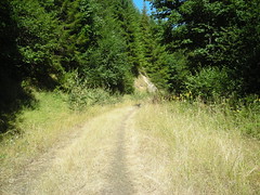
One annoying thing about the haul road on the west side of the Nehalem divide is that the parts that aren’t being actively used are grown up like mad – the grass, which is all dried this time of year, is knee high when you’re on a bicycle, and it’s apparently not all grass either. The outside of my left lower leg ended up with a spectacularly red and painful rash that’s still there a day and a half later. Fortunately I wasn’t paying attention to it when I was actually out on the line, though!
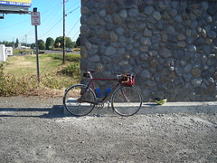
When I reached Pittsburg, I switched over to highway 47 for the ~5 miles into Vernonia, where I stopped for a little something before returning to Portland. Vernonia was crawling with bicyclists that day, though – there was a local charity ride going on and a lot of people were riding into and out of Vernonia (on the ex-United Traction ROW) for the event. The Black Bear Coffee Company was crowded enough so I had to sit inside to eat my lunch, instead of my usual non-rainy routine of sitting out on the patio.
And when I was done, I rode down to the next rail line and hopped on the trail to return to the Portland area. This is a fairly scenic, but otherwise not mentionable section to ride on, and the only thing of interest I did with it this time around is to just stop pedaling when I crested the grade at Tophill and then just coast – for 6.7 miles – down to the bottom of the ramp just south of Pongratz Road (there’s a quarter-mile section past the road where the landowner graded the railroad embankment, so there’s a tiny upgrade just north of a bridge over a stream. That tiny upgrade killed the last of my momentum and I had to start pedalling from that point.)
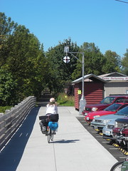
And then into Banks and the end of this section of railroad trail. I stopped at the Banks terminus to refill water bottles and eat an orange, and while I was doing this I first got one of those scammer phone calls, and then when I was getting ready to leave some bozo in a sedan came driving down the main drag calling out to every bicyclist he passed to “GO BACK TO PORTLAND!” (with one pathetic “AND GET OFF MY ROADS!” shouted over his shoulder as he drove off into the distance.) The funny thing about this is I’d suspect that the vast majority of the riders this day were from Washington County, thanks to the charity ride, and there’s no back involved in them going to Portland unless they were doing it for one of the big Portland-based charity bikemobs.
But here I was in Banks with about 45 miles (and one climb over the West Hills) to go to round up to 200km. And I had no interest in dropping down into the Forest Grove/Hillsboro/Beaverton urban area, but instead thought that I could reverse some of the route of the Verboort Flat Tire Extravaganza!, then cut across on secondary roads to get to Old Cornelius Pass road.
I’d looked at maps and knew that it was possible to get from Jackson School Road to Jackson Quarry Road without dropping down to West Union – about halfway between West Union and the upper end of Jackson School the better paved part of the road turns off to the east (and becomes Mason Hill Road) and joins up with Jackson Quarry Road . Every time I’ve ridden up Jackson School Road, I’ve wondered where that other road goes (aside from the vague “connects to Jackson Quarry Road”) and this was the day to find out.
Mason Quarry Road mainly goes up through cultivated fields. There’s very little shade, and it’s quite hot, but it’s less than a mile before you reach the (unmarked; there used to be a road sign but all that’s left is the sign holder) junction with Jackson Quarry Road. And that goes down abruptly to Jackson Quarry, and then turns sharply right and winds gradually up to the heights above Helvetia (passing through a fairly tony suburban neighborhood with some huge ugly houses perched on the hillside south of the road) and then dropping down to the junction with Helvetia Road, which then goes steeply up to a little bit past the Helvetia church, and then steeply down through Helvetia and the junction with Phillips Road, which cuts over to Old Cornelius Pass Road.
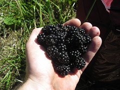
I skipped the Rock Creek Tavern this time around, but when I passed a large blackberry bramble groaning under the weight of ripe blackberries, I paused for long enough to eat a pint and a half of berries before continuing up to the head of Old Cornelius Pass Road and onward to Skyline. Skyline Road has, as is traditional, a large number of extremely fit riders on light bicycles cruising back and forth, so I was a slowly moving obstacle course all the way down to Saltzman Road, where I gtfo'ed Skyline for a nice gravelly descent down what used to be a logging plank road to highway 30 and the last 15 miles to home.
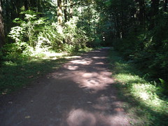
To call Saltzman Road “gravel” is perhaps giving the wrong impression. It is (mainly) gravel – from looking at the surface I think it was macadamed once upon a time, but that was many years ago and most of the tar has disintegrated – but inside Forest Park it’s very well maintained and doesn’t have the sort of spectacular potholing that the two City of Portland sections on each end have. So you can just release the brakes and slither all the way down without worrying that a GIANT POTHOLE will leap up and eat your bicycle. I didn’t completely release my brakes, though – there are a good number of hairpins and I didn’t want to see if I could skid over the edge of the cliff-face :-)
And at the bottom, of course, you’re back in the city. So highway 30 to St Helens, St Helens to Vaughn/Thurman, Vaughn/Thurman to Naito, and Naito to the Hawthorne Bridge, after which I jumped onto the Springwater Trail (Portland Traction) for the ride down to my house.
At the foot of the Springwater Trail (Spokane Street) I realized two things; first, I was almost exactly six miles short of 200k, and secondly I was ravenously hungry and if I stopped at home to get something to eat before wrapping up to 200km I would never get out of the house again that night. So instead of taking Spokane Street home, I took the gravel part of the Springwater Trail down to Garthwick, circumnavigated Garthwick, then detoured through the Milwaukie industrial park before jumping back onto the Springwater Trail to ride out to 45th, where I turned back and rode city streets back to Tacoma, then 17th/19th back to home, finishing up with 200.5 kilometers and my second R200-length loop of the month (in about 10h30; not nearly as slow as the bridge of the gods preride, but still pretty slow.)
At least I can consider the 27 miles of gravel as a good excuse for being slothful!
I never did manage to catch up to Ed and company, but there are many pictures to make up for that.