A slight change of plans
On Friday, my plans were to wake up earlyish on Saturday morning, then go out for a leisurely 200k up to and around Sandy (perhaps the Sellwood->Devil’s Backbone populaire I’m building, with an extension out to Zigzag to push it over 100 miles, then some fiddling around closer to Portland to pick up the last 20 or so miles.)
Unfortunately I’d been running so short of sleep all week that I didn’t wake up until 11am, and then didn’t stop feeling like a stunned ox until almost 2pm. So that killed that plan deader than a doornail (I’m faster than I was a couple of years ago, but I’d need to do a 7 hour R200 to get back home at a reasonable time, and I don’t have either the body or drugs needed to get to that pace) and I had to throw my plans out and make something up as I went.
Donuts are, of course, an essential part of any ride up towards Sandy, so I had to pack very lightly to leave room for cargo; I tossed on a tee-shirt and jersey (actually a “jersey-ish”; I wore my now ancient and somewhat tattered Ibex shak jersey which doesn’t have the back pockets you’d expect to find on something you’d call a jersey), stuffed one of my only waterproof in my dreams vests into the rando bag, then filled one of the side pockets with science diet and the other with my smallest CBC (a Kodak C763 which used to be Silas’s before the lcd screen was cracked, and which further got battered when I hit a deep pothole on Powell one afternoon, which ejected the camera right into the path of the bicycle. The optics survived that crash, but not the lcd screen. Whoops!) and wandered out the door with little in mind aside from getting up to Sandy.
One of the things I’m working on right now is building up a from-my-front-door populaire to go along with the stack of longer permanents I want to do. I’d ridden it a few weeks ago (before the flèche, the 600, and the 200) and found a few places where I wanted to investigate alternatives. On the outbound leg, I wanted to see how it would work if I extended the leg on Waybill Road out to Revenue Road (just because of the name “Revenue Road” :-)) and on the inbound leg I wanted to see if there was any way I could avoid the approximately 95 million stop signs on the Davis greenway between 70th and 15th. I can alway just ride out to Davis & 70th any day, but Waybill & Revenue is well suited to combining with a donut run.
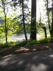
So out I went, following almost exactly the route of the Sellwood->Devil’s backbone populaire until I reached the intersection of Waybill and Orient, at which point I just continued east until Waybill dead-ended into Revenue. It’s much nicer than Orient through here; the road travels through much the same countryside (it’s at most a mile east of Orient) but it’s a tertiary road with quite a bit less traffic. It does dead-end into Orient, but it does that just north of Compton Road, and from there it’s only a couple of miles up to Kelso, where I switch to Kelso road for the run up into Sandy proper, where I made another little detour from the route onto newly built residential streets that loop through a new housing development (densely packed houses – more densely packed than most of Portland – crammed onto a hillside just south of the new Sandy High School) and drop me off on Bluff Road just south of the old Sandy High School. Don’t look for these streets on g**gle maps – they’re new enough so that the map just shows dead-ends and empty fields with my gps track wandering through them.
And once I’m in Sandy, what do I do? Bumbershooten! And then after that I needed to figure a way back.
I’d thought that I would just trim the route short here by dropping down Ten Eyck to Dodge Park, then climbing the Lusted ramp and taking the Mount Hood Railway back into Orient, but as I was dropping down into the Sandy River gorge I decided that I would be better off returning via Bull Run Road, and then, after crossing the Revenue Bridge (I wonder if it’s the same Revenues who named Revenue Road?) and approaching the junction with Marmot I thought that it would be a shame to come out this far and not loop up to Shipley Road.
It’s only about a mile from Ten Eyck to the upper end of Shipley, though you can’t really tell when I’m creeping up the ramp. But at least from the creepy snail on a bicycle viewpoint I’ve got, it’s shorter today than it was a month ago, and the descent on Shipley is gradually graded enough so I can actually clatter on down it without needing to lean on my brakes excessively. And after Shipley road comes Bull Run Road, which gives up a couple of hundred feet almost immediately, then demands it back with interest in one lump sum payment of 7-800 feet.
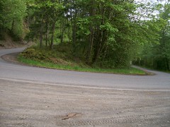
A lump sum payment which is getting easier, if not any shorter, to pay. These days I’ve actually got enough energy to climb that ramp in something other than the absolute bottom gear on the mlcm even if I’m pushing a dozen donuts up the hill with me. I did stop about 2/3rds of the way up, but that was because I wanted to take a picture of the hairpin curve there, not because I was about to die.
And from the top, it was all downhill (mainly) though woodlands and farmland to Oxbow Park and the 400 foot climb back out of the gorge. About a quarter of the way down, I was passed by a bunch of motorcyclists on their Harleys, then about halfway down I had to stop because there were a couple of Multnomah County sheriff’s cars blocking the road where one of the Harleys had dumped, then slid off into the ditch (without injury? Nobody was down and the body language of the sheriffs were not the sort of jittery thing I’ve seen when police are trying to guide traffic around a bad accident.
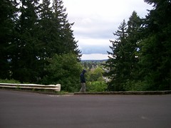
The sun came out when I reached the descent down into the gorge at Oxbow Park, which didn’t make the climb out of the gorge seem any less steep, but certainly made it more pleasant (but not for my legs; by the time I’d made it up to the top of the Oxbow ramp my legs were feeling pretty rubbery, so I decided to follow Hurlburt into Springdale instead of climbing Evans up to Corbett and the Women’s Forum) and, by the time I descended into Springdale I had recovered enough to take Woodward across to Troutdale instead of following the Columbia River Highway back down into the gorge. Woodward is shorter than taking the Columbia River Highway, but it also climbs a lot more going out of Springdale, so any benefit I might have gotten from it was rudely taken away by having to claw my way up onto the point of land above Troutdale. But at least there’s less traffic, and the part where it cuts along the hillside has a somewhat more comfortable shoulder (I’d needed to ride this anyway, because it’s part of Piled Higher & Steeper! and we’d missed in when we cut the route short on the last preride.)
And then I was back in the city, winding along the Columbia River Highway into downtown Troutdale, then up Halsey to 238th, where I cut over (and up the bluff through Wood Village) to Stark Street, and from there over to Burnside for the long ride into town.
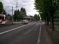
One nice thing about riding along Burnside, of course, is that it follows the old Mount Hood Railway route from Montavilla out to Gresham, and that route is now being used by the Tri-Met Gresham-Hillsboro interurban. There are a lot of trains running on that line; it took me about 25 minutes to go from the intersection of Stark and Burnside to 122nd (where I turned south to go down to Market St) and in that time easily 7 trains passed me going one direction or another. Not a good sight if you’re an auto über alles faux-libertarian, but I was happy with it :-)
I went down to Market Street on 122nd because I wanted to see how it would work out for the return leg of the Sellwood->Devil’s Backbone populaire. There are fewer stop signs on it, but once you get west of 92nd Market street pretty rapidly diminishes to being nothing more than a badly paved alley before (if you miss the jog south to Mills) ending alltogether and forcing a jog north to Clay Street before running into an unsignalled intersection with 82nd. Pity, too, because I’d rather route people along Market than along Davis, but an unsignalled crossing with 82nd is much worse than stop signs, because 82nd is likely to be physically dangerous .
And then I went home; I zigged down to the Lincoln Street greenway, which took me over the shoulder of Mount Tabor, then down into Ladds Addition, where I then made my way down to the Springwater Trail to loop down to Spokane and then go up 17th to my front door. Despite the 30% chance of rain, the showers held off until I was about halfway between downtown and Spokane, when a light drizzle started and kept going until I picked up my bicycle and carried it in the front door.
And then I ate 3 more donuts. Yum!
40-odd photos in 70.75 miles & 4100 feet of climbing @ 12.9 mph semi-brevet time (I turned the gps off when I was in Joe’s Donuts.) The CBC, despite not having a viewfinder or working lcd screen (about all I can use the screen for is an indication of whether it took a picture or not; the screen flashes when a picture is taken) is easy enough to point so that most of my photos actually turned out to be photos of the item I was intending to photograph. The light balance sucks, which is to be expected from a cheap point-and-shoot that has been run over by a bicycle, but some of that can be corrected by brutal photo retouching.
Comments
Comments are closed
I don’t know if you noticed, but in addition to Mill actually not degenerating into a gravel alleyway, it also offers a signalized crossing of 82nd. I like Market as an east side connector very much. When I lived at 60th and Ash, I would frequently leave the Springwater at 122nd on my way back into town from the Mt Hood Nat'l Forest to take Market for most of my remaining westing.