Out on the line (preriding the preride for the Verboort Flat Tire Extravaganza!)
This year I’m one of the organizers for the Verboort Sausage Populaire, so I thought that riding out to Forest-effing-Grove, riding the loop, and then returning would be a good way to get (something close to) my second 200km loop of the month as well as getting, hopefully, a chance to ride the thing without the torrential downpour and countless flat tires that made my last attempt a somewhat less than pleasant experience.
So I sat down last night, plunked the bicycle into the repair rack, replaced the tires with a pair of continental gatorskins, finally ziptied the dynamo taillight into place, loaded the handlebar bag with science diet, set the alarm clock for 6am (I was planning on a somewhat later time, but I had to get back home before 5pm) and went to bed.
This morning, despite the agonising screams of my common sense, I woke up when the alarm told me to do so, dressed, ate some breakfast, then hopped onto the mlcm and headed for the Sellwood Bridge and points west. There was a heavy bank of fog along the Willamette, so the trip across the bridge was done in a grey cloud, but when I reached the west side of the river and climbed up the bluff (via Taylors Ferry->La View->Corbett->Custer) I climbed out of the fog and into an absolutely clear sunrise.

(La View seemed like it was a fairly gradual climb when I went up it at 3:30am on my way to the Three Capes R300 but it turns out to be much steeper when I can actually see it. But it’s still much less steeply graded than the lower stretches of Corbett, and it doesn’t take me up higher than Barbur like the route through Riverview cemetery does. And once I’ve reached Corbett, it’s only 5-6% grades up to Fulton Park, and that puts me onto the ex-Red Electric ROW which is much less enthusiastically graded all the way up to the junction with the Beaverton-Hillsdale highway (and then it’s all downhill from there.)
But, alas, as I went downhill I noticed first that it seemed to be colder on that side of the hill and, secondly, that the fog was still squatting over the valley once you got out past Oleson Road (and this fog stuck around for a /long/ time, too; I didn’t break clear of the fog until I was well north on Jackson School Road.) This made for a fairly uninspiring trip out to Forest Grove (24.43 miles & 95 minutes from home to the Grand Lodge, including a couple of stops to wipe the condensation from my glasses) and a high-speed grope through extra-heavy fog (with quite a few stops to wipe the condensation from my glasses, even though the fog was heavy enough for that not to make much difference) until I was back into Hillsboro and enjoyed several fog-free stretches as I rolled eastwards towards the first transit control at Longbottom’s Coffee.
I was moving along fairly quickly (the first 70 miles were at a 15mph clock average) so I was fairly close to Longbottoms when I started to see several large groups of cyclists coming the other way. I’m fairly certain that they were all Portland Velo members out for their regular saturday loop(s), because just as I turned up 235th for the loop around Longbottoms (I wasn’t planning on stopping, because it was cold and wet and I was on a deadline) I passed the last group of riders which included another local randonneur, all dressed up in her Team Bag Balm jersey. We waved at each other, and then chatted briefly when I overhauled that group about 5 minutes later and rode along with them until we reached Sewell Road and I turned north to run through exploding tire alley.
Sewell Road is a pretty crappy road, and it drops you off on Meek Road, which is even crappier (Meek Road is where I ran over something that exploded and lightly shredded my rear tire (and replacement inner tube) last time I rode this loop, so I treaded very cautiously along this segment. Fate smiled on me, because I reached Jackson School Road with all of the air still in my tires.
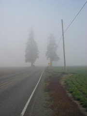
Jackson School road was very foggy for a long time, but then I dropped down into a small valley just north of the Oregon Electric railroad crossing and by the time I started climbing out of the other side I’d cleared the fog, and from that point on almost the entire trip (except for a mile or so around North Plains) was done under a cloudless sky.
Dairy Creek road (and the misnamed Fern Flat Road – it’s a road, and there are ferns around it, but it’s not flat!) are very nice when it’s not raining. Sure, the steadily increasing grade as you wind uphill to the end of the pavement at what used to be Snooseville plays wickedly with your average brevet speed, but once you reach that control and turn around gravity will cheerfully help you get some of that average right back again (I was averaging 15.3mph when I turned onto Dairy Creek Road for the trip up to Snooseville, was down to 14.8mph when I ran out of pavement, and was back to 15.2 by the time I was back to downtown Mountaindale) provided that you don’t end up losing your bicycle into one of the impressively nasty potholes that Fern Flat road is paved with. And from that point on, it’s all bumpy for the next 30 miles. Mountaindale Road goes up and down 4-5 times between Mountaindale and the aptly nicknamed “Frogger Junction” with highway 26, then up and down 3 times between Frogger Junction and highway 47, and then, after a roll through Banks, Cedar Canyon road does its own version of being a rollercoaster before it dumps you onto highway 6 for the mileandchange ride alongside high speed traffic until the turn off (and climb UP) Stafford road, which deposits you onto the hilly but trending downwards Strohmayer/Kansas City Road.
And there’s a barn along the Kansas City part of the road that’s been decorated with what looks like a hundred or so pairs of antlers. I didn’t see that one last time around, thanks to the rain and the flats, but it’s every bit as impressive as the Orrando page blurb says it is.
And then I turned onto Kemper Road, which goes directly east until you have to go south on Visitation (it’s officially a “right turn” on the cuesheet, but if you keep going directly ahead it will be onto a DEAD END GRAVEL PATH, which is probably not what anyone would think is the right route to take at mile 62 of a 62.7 mile populaire.) And then the preride was done, and all I needed to do was get home.
Before I set out, I was worried that I might have to cut the loop short for time. Ha Ha. It’s amazing just how fast I can finish a loop when I don’t have to deal with flat tires in the rain. Last time, it took me about 7h20 minutes to get around this loop, but this time it was about 4h18 minutes, and it would have been faster except that the science diet failed me in Banks and my average speed dropped from 15mph down to under 13mph for the last 15 miles of the loop.
And, alas, I didn’t get 200km; I was thinking of looping through downtown and taking Barbur all the way out to Bertha & the Beaverton-Hillsdale highway, but was worried about timings and took the most direct way instead. So even looping through downtown (and riding the Springwater Trail from there into Sellwood, including the 4 blocks of brand new not even paved yet trail from Umatilla to Linn) only gave me 119.8 miles (in 8h48 minutes, thanks to a couple of stops for fud in Cornelius and Portland; I made 100 miles in 7 hours and a handful of seconds) instead of the 124.mumble miles I needed for a R200.
All of the pictures are here. And now I need to sleep.