Let’s go exploring!
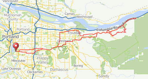
There are quite a few secondary roads up on the mountain between Gresham/Troutdale & Multnomah Falls, and I’ve been planning to explore them for a few years now. So why not take advantage of my first free-route permanent to wander around in the mountains?
I give greater than even odds that I’ll end up walking the bicycle de jour down Palmer Mill Rd (gravel, with up to -20% grades & über-sketchy in sections; I’ve already had one horrible crash on a gravel descent, and if I walk I’ll be able to enjoy the scenery instead of trying to keep the bicycle at subsonic speeds) or bailing out onto Alex Barr instead (steep, but paved and way shorter.)
Comments
Aha. Metro has an area biking map that shows it as paved, but I’m perfectly happy to ride it despite the map being wrong.
Even excluding the Portland watershed there are still a good handful of tertary/logging roads that are screamingly inconvenient for including in permanents. Not too many south of Larch Mountain Road (I don’t know if the NF1509/NF20 couplet is blocked to access – NF20 isn’t in the Bull Run watershed until after the junction with NF1509, and the NF1509 gate is only signed to disallow motorized vehicle access. NF20 is pretty enthusiastically trenched at the Larch Mountain Road end, but I didn’t go very far on it when I last checked it out) but north has some logging roads with a lot of potential – might be a bit of a task fitting them into a 6h45 loop time, but I’ll never know until I try!
EDIT: I found a Water Bureau map showing the BRWMU and the closed area and NF1509 runs right along the edge of both of them. Basically if you stay in or north of the transmission line corridor you’re just in the national forest, but if you go one inch into the woods to the south you’re in no mans land. And the restricted gates (Road 1509044 Gate, Road 20 Gate) are directly east of the complicated little dirt road junction where 1509 and 20 meet up.
And, at least from satellite imagery, Road 20 is there (albeit as barely more than doubletrack) from about 500 feet south of Larch Mountain Road to the junction point. I guess it’s time to call up the Water Bureau and find out what the official scoop is.
Comments are closed
Be advised that Alex Barr isn’t paved. James, Theo and I rode it a couple years ago, and it’s definitely gravel. Also, all the roads south of larch are part of the bull run management area, and thus of limits, which is a bummer.