A somewhat slower populaire
One day (or two?) before I did the checkride for my High Rock 300, my friend Kevin mentioned that he was going to be riding his Cedric Diggory populaire (Brooklyn to Vancouver, then up along what used to be Washington Highway 501 until it ends, then back) with Lynne Fitz on Sunday morning.
Well, I wasn’t doing anything on Sunday, and it seemed like it would be a lovely thing to do as a digestif for Saturday’s 300k, so I asked if I could go along, and got onto the ride.
It started at 9am, in Brooklyn, at what turned out to be a now-closed convenience store, so I started the day off by looping from the closed store to Kevin’s house and back to the closed store again, where I finally met up with Kevin and Lynne, not more than about 2 minutes late. And then we headed north for Kelley Point.
There are a few ways to get from the south side of town to the north side of town. Most of them have about 6,000 traffic controls. The trip across to Willamette Blvd took a considerable period of time, because basically every corner had a stop sign, if not also a stoplight, and we were all pretty happy when we finally reached Rosa Parks Way and could ride, uninterrupted, for blocks at a time on the way west to Willamette Blvd, then north to Lombard, then Marine Drive.
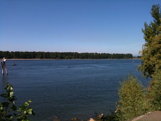
I’ve ridden Marine Drive a lot over the past four years, but most of the time it’s been from east to west, then north to south. We were riding south to north on this trip, and, goodness, there was a lot of traffic – all trucks – moving up the road and in the direction of I-5. We tried to stick to the road, but only made it about a mile away from the intersection of Lombard before we gave up and shifted over to the bike path (concrete slabs, which we went *bump* *bump* *bump* over for the next 3-4 miles before we actually reached Kelley Point Park.) Sadly, the info control for Kelley Point Park wasn’t inside the park, so we didn’t have a chance to pop down and see the slightly deranged historical marker.
And then, after the Kelley Point info control, we continued, on bike paths, east to the Interstate Bridge and our jump across the river into Washington. We stopped briefly at the restrooms at the east end of the Smith & Bybee Lakes area, paced a train on the N/S mainline to Vancouver, then, after skittering by where the ex-steamtug Jean and landing craft LCI(L) 713, onto the horrible maze of twisty passages and narrow noisy sidewalks that take you from Oregon over to Washington.
After this, the crawl up through downtown Vancouver (which really needs a trolley line, though sadly may not get one for quite a while because of anti-Portland agitators) seemed fairly uncomplicated, and we soon reached Fourth Plain for the run up to the end of Washington 501 (which used to go further, but, alas, it was built along the Columbia River for scenic views, but then the river cheerfully washed out large sections of it for several miles a few decades ago, and the state decided that it was too expensive to rebuild the road.)
There were bike paths to ride along, and, alas, a moderate headwind that slowed us down to about 15-16mph on the way up, but at the end of the road we could eat blackberries and take pictures of Sauvie Island (which I am becoming fairly familiar with, thanks to riding the eff out of Kevin’s Cuthbert Binns populaire) before turning back south and heading back into Portland.
I’ve gotten considerably faster this summer, but have not mentally adjusted to this, so when I’m in the front of a group of people I tend to put on the gas so I won’t hold them back, only to lose them because I’m no longer quite so pokey as I was. So I made certain to not be in the lead, but to follow along. So this kept our moving speed down to about 20mph as we screamed back into Vancouver, only slackening when we popped over the BNSF railroad yard, and then slackening to a stop at a park in downtown Vancouver where we used the bathrooms and got some more water.
And then back into Portland via the same stupid bridge and maze of twisty passages. And then we got onto Marine Drive again and headed east for the airport and the section of bike path that leads from 34th over to the I205 path. A light tailwind let us wind up a bit here, and we flew all the way over to I205, then slowed and ground our way up the I205 path through Maywood Park and the Gateway Transit Center.
And then it was all downhill from there. We took the I205 path down into Lents, crossed over to Woodstock (via Harold, Ellis, and 87th), then worked our way west towards Westmoreland. At 52nd I delayed our forward progress when I hit a pothole, then a sunken drain, didn’t crash, but managed to eject my poor camera onto the street and had to recover it. We flew through Eastmoreland (helped by the nice steep ramp down from Chavez,) rode up Bybee to 17th (where I failed to DNF by turning north rather than south :-) and up 17th to what would have been the closing control at 17th & Holgate.
Since that control was closed, we just remembered our arrival time and relocated to Kevin’s house to do the paperwork, then sat around and chatted for half an hour or so before we pried ourselves to our feet and headed off in our respective directions.
5h24 for the loop, which was a nice refreshing change from the faster loops I’ve been doing. Pictures? On flickr, of course.