taking the Wheatland Commuter
When we started planning to go down to Pacific City for a week, one of the early preparations I did was to make up a pair of transit permanents to get there and back. The trip out, a simple 160k loop that features 99W and the Nestucca River Road, is a good lazy morning ride (if climbing 4500 feet or so is your idea of lazy) where you can leave at 10am and still make it into Pacific City before dinnertime. The trip back is a somewhat longer loop that takes the Little Nestucca River Road, then cuts east across the Willamette valley until it splashes up against the foothills of the Cascades, then heads north to get into Portland (via a route that is not 99W through Tigard.)
I rode down on the Nestucca River populaire on Monday, and yesterday it was the return route’s turn.
This route felt like two different 100k rides laid end to end; the first one was cloudy, cool, and still, and I cranked out the 62 miles from Pacific City to the Wheatland Ferry in under 4 hours. But after I got off the Wheatland Ferry, I spent the next 100k riding east, then north against a stiff headwind (I passed one of those plywood “house for sale” signs north of Molalla and the sign was lying horizontally as the wind attempted to blow it away from the signpost) and took over 6h30 to claw my way back home.
The day started nicely enough; when I got out the door of the cottage, it was cool and cloudy, with some fog still clinging to the top of the Coast Range, but I warmed up pretty quickly as I proceeded (on the traditional Three Capes 300k route) south out of Pacific City to the western terminus of the Little Nestucca River Road. I had my cellphone in use as a music player, and I guess it helped, because I shot up the Little Nestucca River Road at an almost flatland speed (~15mph average) and reached the junction with Hebo Road, and then the top of the pass, almost before I knew it (1h05 to the top of the pass), then tipped down and flew down into Grand Ronde, where I jumped over to highway 18 for the short run out to the portage to the Yamhill River Road.
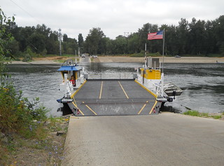
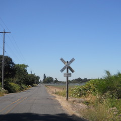
The connection to the Yamhill River Road is not terribly obvious, but fortunately I’m not the only person who’s had the idea of portaging there, and there is an obvious path there that gets you off the shoulder of 18 and down to the end of the road (about 50 feet.) I guess it would be possible for someone to just ride down there, but I just hopped off the mlcm and walked it over to the road. And then it was a quiet 4 miles over to the highway 18 crossing, and a slightly busier six miles down to the first control in Sheridan. And then off to the east, still following the route of orrando’s Three Capes 300, but eventually diverging from that route in Amity, where I continued going east and over the range of hills that separate Amity from the Willamette. And eight or so miles later, I rolled up to the Wheatland Ferry landing, just in time to see the ferry pull away and sail across to the other side of the Willamette.
I reached the east side of the Willamette a little bit after 10am. At this point I thought that a <8hr 200k might distantly be doable, but a more realistic loop time would be slightly less than 9 hours. The weather, however, had a different idea about my brevet timings, and from Wheatland east I proceeded into the teeth of an enthusiastic headwind under a blazing sun.
I tried to keep up my pace, but found it increasingly difficult to do so. By the time I’d cleared Gervais, my brevet average was down to about 13mph, and it inched slowly downwards from there as the unceasing headwind sapped my energy. I was hoping that when I reached the foothills of the Cascades that I’d get some respite from the wind, and I did, but the foothills of the Cascades came in the form of Wildcat Road, which went enthusiastically up in a series of ramps, many of which were so steep that I had to drop down to my dump gear and stand up to get even a slow creep up the ramps. (I had ridden Wildcat Road before, during the spring 200k, and it didn’t seem that bad, but I was riding with a friend then and we were riding south instead of north.)
Eventually I fell out of the foothills down to Molalla again, but by then I was out of water and getting close to being out of energy. The gas station that I used for a control on the Molalla 200k had closed, but fortunately there are several other stores (a Subway, a Hi-School Pharmacy, and at least one other convenience store) on Molalla Ave north of highway 212 so I could stop, get water and soda, then sit in the shade for a while before heading out again.
Now, one of the things I had forgotten when I headed out to Pacific City this week was to print out a brevet card and cuesheet. So I loaded the cuesheet onto an iPad instead and I was periodically taking it out of my rando bag and trying to memorize the next half dozen cues. This had been working pretty well (at the cost of having to stop repeatedly to pull out the iPad to read the cue sheet) but north of Molalla I fell victim to a bikeroutetoaster miscue (a R onto Sprague Ave was listed as Sprague Ave/Vicks Ave) and turned L on Vicks Ave, which is about a mile south of Sprague Ave, and rode all the way to highway 213 before realizing my mistake.
Oh well, can’t be helped. A few extra km never hurt anyone, particularly since the route hasn’t even been approved yet.
But once I fixed that, it was easy going as far as the cues go. There are a grand total of 3 turns from Sprague Ave before I reached highway 170, which is a really familiar route into Canby, and from Canby I’m basically home as far as my familiarity with the route goes. So into Canby for the Canby control, then east to Central Point Road, north to Criteser, east to Leland, and Leland into downtown Oregon City.
I ran out of water on Leland (after stopping in a patch of shade to cool down halfway up the hill; I looked at my watch here and it was already 9h07 into the ride, which meant that not only was I not going to get a <9hr 200k, I wasn’t even going to get a <10hr 200k.) so I stopped in Oregon City for nasty sports drink and strawberry milk, then pushed onwards against the wind.
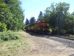
When I reached Milwaukie, I stopped briefly to photograph a P&W train that was paused on the Oswego Branch waiting for access to the ex-SP mainline, but that was the last stop of the trip and I rolled into my driveway at about 4:25, 10h33 after I started the ride in Pacific City.
My moving speed on this brevet wasn’t that bad (13.9mph) but my brevet average was just shy of 12mph (12.1 trip average, but that includes the Vicks Road bonus miles.) Drat, I wanted to do the loop faster and avoid the afternoon heat :-( Pictures are, as is traditional, on Flickr, and if you find my sanity on the road you don’t need to return it.