Circumnavigating Highland Butte
A bunch of people are planning on riding my Volcano(e)s vs. Farmlands loop on January 2nd, so I needed to go out and verify that the two info controls were still good. The first info control is in Oregon City, which is a “if you have 80 minutes you can hop on down and check it out”, but the second one is up by Highland Butte, which is a somewhat more substantial distance. And the second one really needed to be checked, because when I did the preride with Ed we forgot to actually stop at the designated control point and set up a control. (whoops!)
I was planning on riding up there the 26th, but I came down with a bit of a cold on the 25th. However, it didn’t appear to be a fairly serious cold, and I found myself feeling more-or-less human on the 27th, so I decided that I might as well leap at the chance to do the loop before the rain came in (a storm system is rolling through the area this week, and it’s scheduled to dump a metric bucketload of rain in the highlands before it rolls on out this weekend.)
So, at the crack of noon I loaded up the mlcm and headed south into a cloudy, but dry, winter afternoon. I made pretty good speed down to Oregon City (it’s a ridiculously familiar route by now, and I don’t even particularly notice the one steep ramp just south of downtown Milwaukie unless something goes wrong with the bike) except that I discovered that something in the drivetrain is worn and when I switch to my alpine (34t) ring I can’t use any of the gears higher than the 32t dump gear for climbing, because if I’m in one of those other gears and I attempt to crank up a hill the chain skips horribly. So I had to either chug upgrade in the 50×28 gear or drop alllll the way down to 34×32 and creep, sluglike, up any substantial ramps.
So as a result of this it meant that after a (moderately) speedy run down to Oregon City, a stop to note a new info question there, and another moderately speedy run up to Fischers Mill, my average speed immediately dropped like a stone when I reached the first ramp on Ridge Road.
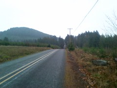
But at least it’s a scenic way to creep up the side of a volcano. Most of Ridge Road is fully equipped with hobby farms, and most of them come with a llama or ten. And I know about the ramps these days, so they aren’t the sort of unwelcome surprise that they were the first couple of times I ran the trek up the hill. And once you’ve climbed past the lower plateau, the Impassable Wilderness that separates the lower and upper plateaus, then past the two Highland Roads, you’re right up there by the long-extinct vents of this massive shield volcano.
So I stopped, took a few pictures, set a few info questions, and continued on my way. But I wasn’t going to get this far and then turn back, oh, no, because if I continued to the end of Ridge Road I run into Butte Road, which goes either west (down to Beavercreek Road) or east, which takes you up right alongside the tree-covered butte that contains the multitude of vents that grew this volcano. (There’s a jeep road that goes up to the top of one of the vents, but I decided that I wouldn’t try it because
- it’s very steep,
- it’s been trenched to stop people from driving up it,
- it’s dirt, which becomes mud when it rains,
- and it was raining (there was no rain for most of the way up the volcano, but it started spitting rain when I crossed Upper Highland, and this turned into real rain just as I turned east on Butte Road)
So I just went east, climbing all the way, on Butte Road, which dumped me onto Beeson Road which continued to climb up to ~1400 feet before plateauing, then dumping me onto Upper Highland Road for the descent back down off the volcano.
One of the loops I did this year – the Piled Higher & Steeper variant of my Hills to the Yeah! 200k permanent – goes down Upper Highland Road to Highland, then down Lower Highland to Fellows Road, which drops you down into Viola before climbing back up to Springwater Road and onward to more climbing up into the Sandy River basin. I was certainly not going to do any of the climbing in this loop (it was 15:30 by the time I reached Fellows Road) but there’s a little country road called Mattoon Road that’s a water-level connection between Viola and Fischer’s Mill, so if I dropped down the (terrifyingly steep and twisty) Fellow Road ramp I would be rewarded by a nice level run down into Fischers Mill and then a fairly moderate climb up to Springwater Road.
And I wasn’t going to let a bit of rain get in the way, as long as it wasn’t enough rain to compromise my brakes. This is important, because Fellows Road follows a ridgeline away from Highland Butte, dropping steeply but evenly most of the way, until it reaches the end of that ridge and becomes a terrifically steep and twisty rollercoaster down to the bottom of the valley that Clear Creek runs in (you fall off the end of the ridge down a twisty, but managably steep, ramp, and just as you start getting used to it it straightens out, becomes steeper, then rolls into a ridiculously steep and tight hairpin, which dumps you into a straight steep ramp that has a sharp left turn at the bottom.)
And then if you don’t die it’s a nice level ride back into Portland. I didn’t die, so I shot back towards home, arriving at the OR224 mess in Oregon City at about the same time that night came crashing in, and then zipping back home in the dark along River Road, which comes with a nice wide bike lane that is almost never used as a parking lane.
And now I’ve got the info questions, so all I need to do is fill in some brevet cards and take them (and the cuesheets) down to the copyshop to make enough for all of the riders on the 2nd. And someday it will stop raining so I can do this loop again.