Catching up on my 300s, very late in the season
My plan was to have ridden my 300s much earlier this year, but, alas, catastrophes happened and before I knew it it was August (and then I ended up riding my 400 instead of either 300) and then, almost before I blinked, September.
So something needed to be done. I have two 300s, both of which run up into the mountains south of Mount Hood. One of them (Sellwood to Hood & Back, which borrows liberally from the western half of Michael Wolfe’s Barlow 300) treads familiar roads that I’ve ridden at least once this year (with the notable exception of NF 58 to High Rock, which is, um, kind of steep going up to High Rock from the west.) The other one, the High Rock 300, takes roads that I have not used before, plus takes NF 58 from east to west, hopefully avoiding the insanely steep ramps that weigh down the climb up to High Rock.
Plus it’s a new perm and I’ve not even had a chance to do the checkride of it yet. So I set a date to ride it (the 15th) and asked a few of the usual suspects if they wanted to help me checkride it. Nobody did for various reasons ranging from bike camping to wanting to take a rest week before The Big Lebowski (I must admit I can’t think of anything more restful than a nice 300k, but then again I’m the person who warmed up for the summer 600 by riding a 200 two days before it,) so I ended up having to do it by myself.
Which actually worked out pretty well.
My planned departure time was 5am, so I’d set the alarm clock for 4:30 to give me enough time to throw on some clothes and get out the door, but, alas, the inevitable effects of not riding with anyone happened and I didn’t get the mlcm out the door and onto the road before 6am.
The first and last 60 miles of this loop tread very familiar ground; there aren’t that many ways to get out to Ripplebrook (OR 224, looping south through Detroit and coming up NF 46, or, um, gravel forest roads) and the one I prefer is OR 224, which I’ve now ridden up and/or down 11 times this year (this ride, the Hot Springs-Covered Bridges 400, the summer 400k, the summer 600k, and *7* loops of my Portland-Ripplebrook-Portland 200k.) So there weren’t any new surprises for me (aside from hitting 55mph on the Van Curen descent, thanks to sprinting up to the edge of the bluff, then doing a pretty good tuck on the way down) and I could just ride along and enjoy myself.
Not quite as fast as usual, though (4h22 to get to Ripplebrook) because I’d burned off a lot of power by doing fast loops up to Sauvie Island and Sandy in the 3 days previous to the 15th, but the day was just starting and there was no reason to burn off much energy before reaching the hilly part in the middle. And then I stopped in Ripplebrook for over half an hour to eat a nutritious (fsvo “nutritious.” It had a bunch of calories, which, I guess, is something) breakfast and look at the net (my iPhone doesn’t have a data plan, but Ripplebrook has wifi) before I dragged myself, just before 10am, back onto the mlcm for the alpine section.
The first part of the alpine section is on NF 46, which, despite teasing you with a collection of hills just past the end of OR 224, settles down to a distinctly non-alpine gradual climb along the Clackamas River for a dozen or so miles. But then the fun begins – NF 42, which is one of the few paved routes over to Timothy Lake, starts climbing immediately after the junction with 46, and really doesn’t stop until you’re almost at Peavine Mountain, which it then climbs as well.
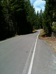
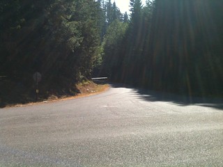
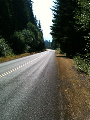
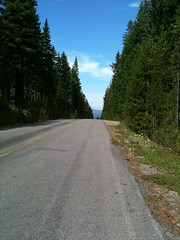
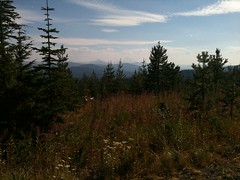
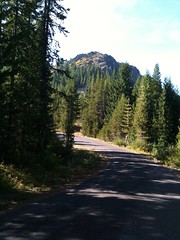
It’s a terrific climb. Maybe averaging 5%(?), so I could bigring myself up it with only a few points where I started to worry about my sanity, and it’s all nicely paved and with very little traffic. Up and up I wound, through clear cuts, new forest, and old forest, stopping occasionally to delayer, make a note to add to the cuesheet (the first cue that bikeroutetoaster put in when I did the route was to not turn off on a road that ended up to be a blocked gravel logging road. No worry about that,) or to take a picture of a particularly scenic stretch.
Before you reach Peavine Mountain there’s a stretch where the road drops down into an alpine valley, then climbs out again. It does this in a sneaky way, by first dropping down into small valleys, popping up out of them (I was thinking “is this it? The topology must be wrong or I got really strong all of a sudden.”) and repeating it until you’re surprised by a long plummet down to the foot of the Peavine Mountain climb, which is noticably steep (but not steep enough to get me out of my big ring.)
This is a moderately long climb, too, but nowhere near as long as the climb I just did. And while I was climbing I saw a few other people on their bicycles, too, including a gentleman that I passed who was in full pain cave mode, and couldn’t be bothered to return the greeting wave I gave him as I passed (and the funny thing about this fellow in his pain cave is that though *I* was climbing, he was descending, and not on a fixie either.)
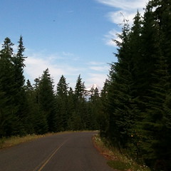
And then I rolled over the pass just west of Peavine Mountain’s summit and plunged down towards Clackamas Lake. A plunge that was interrupted just as I reached about 45mph by the road curving north and all of a sudden Mount Hood was right there in front of me. Sadly, by the time I said “Oh, shit!” and managed to stop I’d descended far enough so that much of the mountain was hidden behind a screen of trees (and I was not going to turn around and climb back up to get a good photo. Maybe the next time I ride the loop.) I took as good of a picture as I could, then continued downgrade to Clackamas Lake, where I rewatered myself (the visitor center appears to be closed for the winter, so I couldn’t see if they sell snacks) and discovered that one of the info controls for Sellwood to Hood & Back had been removed.
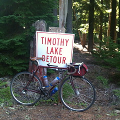
And then it was time to climb again. the road is flat across Clackamas Meadow and up to the junction with NF 57, but then it starts to work upwards towards the junction with NF 58. I started to see “TIMOTHY LAKE DETOUR” signs along here, and those signs were on NF 58 as well as along NF 42. Earlier, when I was having my breakfast at Ripplebrook, the staffers there asked if I was planning on taking NF 57 up to Timothy Lake. I thought nothing of their question (I was assuming that they thought I didn’t know that 57 wasn’t paved past the junction with 58) then, but when I started to see these signs I realized that they were going to tell me about a road blockage or something. In any case, there was a lot of traffic on NF 58 as I worked my way up towards High Rock.
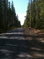
The eastern approach to High Rock is not as long, or as high, or as steep as the western approach, but it has its own moments. It rolls upgrade, so i went over what seemed like an unending series of short descents followed by considerably longer steep upgrades. Not steep enough to get me out of the big ring, but certainly steep enough to make me very slow. And every time I reached the top of one of these ramps, I would be greeted by a surprisingly cold headwind, which got pretty tiring after a while.
Eventually, after more time than I wanted to think about, I reached NF 58’s summit (at ~4550 feet) and the clearcut that normally gives me wonderful views of Mount Jefferson. Alas, this was a hazy day so all I saw was the ghostly white shape of the mountain against the white of the haze.
And then it was time to get down. I’d reached the Mount Jefferson vista/summit at ~3:20, so I thought I’d not get back to Ripplebrook before it closed at 5 (I think it’s about 21 miles away from this vista,) but I’d forgotten just how steep the ramps are here. I made quick work of descending down to the hairpin at the foot of High Rock, but then it started to get scarily steep; the top of the ramp up from NF 57 is maybe a 20% grade, and it’s a fairly straight half-mile down to the first tight curve, so after I rolled around the hairpin and surrendered the mlcm to the embraces of gravity I skooched myself into about as aero a position as I could get. Which ended up being a really good plan, because I’d forgotten (or never noticed) that NF 58 is littered with sunken sections and potholes, and I rediscovered this when, at 40mph, the mlcm went airborne over one of these sunken sections.
It’s a good thing my hair is already white, for otherwise I would have lost my youthful beauty on the spot.
The rest of the descent down NF 57 was a constant battle between me, my brakes, and the rough embrace of gravity – I didn’t want to completely let the mlcm go, because NF 58 is a lot more twisty going down than it was going up, but I didn’t want to ride the brakes because I didn’t want to melt them or the rims during my descent. So I *shot* down NF 58, pulsing the brakes on steeper sections and hoping that I’d not encounter any enthusiastic uphill traffic at one of the curves.
Thankfully, NF57 doesn’t have anywhere near the number of surprise sunken sections and/or potholes that NF58 has, and I could descend it stupidly fast without feeling like I might end up with a(nother) spectacular pothole crash.
It seemed like it took a long time to come down NFs 58 & 57, but it didn’t take much time at all. I dropped around the High Rock hairpin at ~3:30 and reached the Ripplebrook Ranger Station – 16 miles down the road – at ~4:15. So I stopped and had another snack before heading north for the last 100 kilometers.
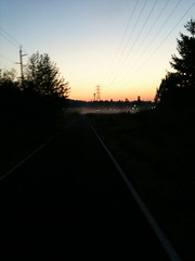
Once again I was on the old familiar ground of my Ripplebrook ↔ Portland segment, so there’s not much to say. There was a headwind, but it was noticable at Ripplebrook so I could get myself up to line speed before hitting the long ramp that takes you down to the Clackamas River (this time I didn’t let up on the gas until I was going 36) and I managed to make it all the way to Carver before the sun finally dropped below the horizon.
It was late dusk when I reached Oregon City, but full night when I turned onto the Springwater Trail for the final fishhook up to an info control before going home. I wasn’t paying much attention to the time, though (I don’t use my GPS as my primary speedometer on the mlcm, because it has poor battery life and not enough memory to store any loop longer than about 500k; but it has a clock, and the el-cheapo Cateye bike computer I replaced it with does not) and was unexpectedly delighted to roll up to my front door at 20:58, 14h58 after I left in the morning.
It’s not, by about 100 minutes, the fastest I’ve done a 300k, but (a) it has much more climbing than those other 300k loops, and (b) I spent a lot of time stopped on this one that I would not have spent on a non-checkride. I’ll have to do it again. Maybe this Saturday, since I cannot carve out 4 days to ride The Big Lebowski.
There are pictures, of course, and there will be a route description sooner or later.
And now I’m only a 600k permanent away from a permanent-SR (motto: “all of the work, none of the credit”) for the year. Sadly, there aren’t any 600k Portland loops yet, so I don’t think I’ll get that SR this year :-(
Comments
I know there didn’t use to be snacks up at Clackamas Lake, but Naile Neel rode Sellwood to Hood & Back the day of the summer 400 and said that there were snacks available there then. So I was going to ride up soon thereafter to verify, but, of course, September 15th was /not/ soon thereafter enough and the office was closed when I got there.
Next summer will come soon enough, and then I can check for certain. I’m sure that NFD 58 will be free of snow by the end of May (or at least there will be little enough snow so I can cyclocross the midlifecrisismobile across the drifts like I did last year.)
Comments are closed
No snacks at the cascade lake ranger station. They do sell maps and guidebooks, though, and have interesting historical photos for perusal.
I ought to get off my butt and file my route for a portland-bend-portland 600.