Permanent 1601 – Portland/Pacific City 160 – 161km
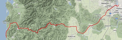
There are basically three ways to get over the Coast Range when you’re travelling between Portland and Pacific City. You can go on Highway 6 across to Tillamook, Hebo Road/Little Nestucca River Road, or Nestucca River Road. The shortest route is to take the Nestucca River Road & 99W, which is what this permanent does.
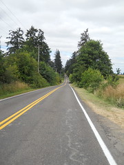
It starts out in Sellwood, works its way down to, then crosses the Sellwood Bridge, and takes my favorite route (Taylors Ferry->LaView->Corbett->Barbur) up the bluff on the other side of the river to get to 99W, which you then stay on for the next 30 miles before you reach the first control in Lafayette. 99W is a typically suburban wide busy road, but it has the advantage that it’s fast (and if you leave at 5 in the morning, it’s not that busy) and it travels through enough suburbs and small towns so that you’re never more than 4-5 miles away from services of one kind or another. And when you get south of Dundee, the road pretty rapidly diminishes to a two-lane country road which is far less hectic than it was closer to the city. But it’s still 99W, and it will probably be a relief to you when you turn towards Carlton on Mineral Springs Road.
Mineral Springs Road dumps you onto Hendricks Road, and you then turn to the west and follow the road for about 42 miles, (in Carlton, it becomes Main St, and then on the other side of the town it becomes Meadow Lake Road, which becomes the Nestucca River Road after a considerable amount of climbing, and you only have to change roads when it dead-ends into Blaine Road about 7 miles east of the town of Beaver.) But before you go too far, you go through Carlton, where you should stop for supplies and to top off your water bottles, because after you leave town there is nothing in the way of services for the next 45 miles, and there’s a great huge hill between you and those services.
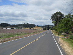
Meadow Lake Road starts off as a gently rolling country road, then crosses Westside Road and immediately climbs a set of huge steep hills before dropping down to the bottom of a valley and working gently upgrade for a while. And then the valley narrows and the road tilts upwards and starts snaking its way up a steadily steepening mountain. Up it goes, through ranches and tree farms, for 5-600 feet before levelling off on a saddle that lasts just long enough for you to think “is this it?” before it tips abruptly up again, climbing more steeply past small farms, woodlots, and just plain woods. One really steep short ramp at the very top of this section and you come out on a second saddle, which is longer but surrounded by enough hills so you won’t think that this is the top (at only about 1200 feet.)
As you start climbing the next ramp, high chainlink fences start appearing north of the road, all signed “CITY OF MCMINNVILLE WATER DISTRICT. KEEP OUT” at regular intervals, and eventually you come up on a very short saddle with a water district access road dropping off to a gate to the north. Are we done?, you might think? No, sadly not, because very soon after that access road Meadow Lake Road turns into two miles of an increasingly raggedy logging road (paved, but the pavement has seen better days and whoever is responsible for maintaining it isn’t really spending much time or money on it) which once again tips severely up and climbs up a moderate ramp to a BLM informational kiosk that marks the point where Meadow Lake Road becomes the Nestucca River Road (and becomes well-paved again, thank goodness!)
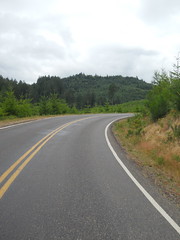
But are we done climbing? Oh, no, not in the least; the Nestucca River Road drops away to the west for a while, then starts climbing a gradual ramp again out into a logged over area where it appears to be aiming for a gap between two mountaintops. But, sadly, as you reach the end of the logged off area, the road curves sharply left and runs you all the way up to the mountaintop to the south, where it finally relents and levels off.
At about 2000 feet.
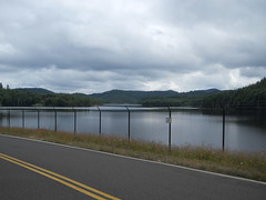
You roll along on gently undulating roads for a while, and then come to a large lake nestled in the mountaintops. This is McGuire Reservoir, and it’s the water supply for the city of McMinnville, and it also marks the top of the climb; to the west, it’s basically all downhill from here, and you can start making up the time you lost climbing up this hill.
There’s a 2.5 mile gravel stretch along this descent, but, sadly, I’ve never ridden it because on the day I did the checkride there was a construction project going on that blocked the gravel section and forced a slight detour. I’d dropped about 300 feet off the top of the mountain when I encountered a ROAD CLOSED sign which detoured me up a side road to get around it.
The side road is Bald Mountain Road (the detour is L Bald Mountain Road, R Bible Creek Road, L Nestucca River Road,) and it says “hello, sailor!” by going up 1000 feet in the first 3 miles, but to make up for it it’s a fairly quiet road and the view from the top is very nice. And then it rewards you by giving you 15 miles of fast curvy descent on quiet roads with good sight lines. It’s 5 bonus miles that are not to be missed (I will never put an info control on the Nestucca River Road to keep you from this detour) and will keep a smile on your face all the way down to Beaver.
But in either case you go skittering down the Nestucca River Valley all the way to the next control (and services) in the town of Beaver, which is less than 20 miles from the finish. And after getting your card stamped and restocking, you head north for a few miles on highway 101 before turning back towards the ocean on Sandlake Road, which runs west towards Cape Lookout for a few more miles before turning south and running you towards Cape Kiwanda and the end of the line in Pacific City. When you’re almost to Cape Kiwanda, Sandlake Road turns inland, but you continue directly ahead on Cape Kiwanda Drive along the beach, then around behind the cape before dropping into the northern side of Pacific City.
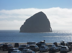
When you enter Pacific City, the Pelican Pub (and Pacific City’s Haystack Rock) will be off to the west, but resist the temptation to stop here because you still have a mile and a half to go. Carefully proceed south along Cape Kiwanda Drive (the road is not in the best shape and it has a series of spectacularly toothrattling potholes just sitting there in the southbound lane waiting for you,) then turn back east on Pacific Ave, ride up to Brooten Road and you’re done!
There’s a Shell Station on the NE corner of Brooten road that you can get a receipt at, or if you’re hungry for real food there’s a BBQ place a block south on Brooten, the Grateful Bread cafe a couple of blocks north on Brooten, and a couple of other beach town restaurants scattered between those places. And about 10 blocks north on Brooten is Pacific City’s little supermarket, so there are many choices here.
When you’ve got your card signed, then you can go back to the Pelican Pub and have a drink or two while figuring out which permanent you’re going to use to get back to Portland.
Pictures from my checkride are on flickr, you can look at the cuesheet, and you can contact me to ride this route for RUSA credit.
Comments
Oh yes indeedy – that detour nicely clips out all of the gravel :-)
Comments are closed
so wait, if you take the 5-mile detour away from nestucca road, is the whole thing paved? Cuz if so, I think I need to do this:)