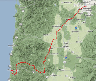
Permanent 1617 - Portland-Summit-Newberg – 228 km
Last year I rode a 600 that crawled over the Coast Range just north of highway 20, then proceeded north for quite a long distance along King’s Valley Road before it jumped off onto tertary roads for the final run up to Forest Grove. And this spring I rode down to Newberg, then rode the first 70 miles of a 600 that went south along King’s Valley Road before turning to cross the Coast Range again, just north of highway 20.
So when the family got a last-minute invitation to spend a week down in Newport, it didn’t take long at all for me to decide to take the midlifecrisismobile down instead of wedging myself into a car for the long trip there. And then I drew up the map and realized that this would be an ideal route for a permanent; mainly secondary roads (except for the initial 20 miles of 99w, which isn’t that bad if you do it at 5 in the morning,) no bizarre routing to make up miles (the Summit/Nashville/Logsden routing is to avoid highway 20, which has no shoulder, is very narrow, very twisty, and choked with traffic. Oh, and it’s also clogged with construction debris because the DOT has an ongoing project to try to build bypasses around the worst twisty parts. Trust me, you do not want to try and ride that segment.)
So.
This route starts, as is traditional, in Sellwood (at the intersection of Bybee & Milwaukie) and heads south. But unlike most of my other routes, it turns west at Tacoma and crosses the (soon to be replaced with a more bike-friendly) Sellwood bridge, then switchbacks up the bluff to Barbour Blvd (aka 99W, though you will not see any signs saying that it’s 99W until you reach Tigard) for a 25 mile run south to the junction of OR 223, which takes you cross country past Dayton and Amity to close to Perrydale, where you dodge a little bit west (and past a traction engine that’s displayed in the forecourt of an abandoned gas station) to take Perrydale road over hill and dale into Dallas, where you rejoin OR 223 for a 25 mile run up Kings Valley and a short stretch following highway 20 to Blodgett (and the Blodgett Store, which has very good hand-scooped ice cream.)
From Blodgett, you flee highway 20 for the much quieter environment of Summit Highway, which wanders across the highlands of the Coast Range for a half a dozen miles before plunging down into the Yaquina River valley and into the tiny town of Nashville (just before the road plunges down into the valley you’ll go under a railroad bridge, and just before you reach Nashville you’ll go over a railroad crossing. It’s the same railroad; it just took a somewhat more circuitous route to get to the bottom of the valley than the way you’re taking.)
And at Nashville, Nashville Road urges you to go left and back to highway 20. Do not pay attention to it; you want to go right, onto Logsden Road, which is a much quieter and (mainly) well paved tertiary route over the mountains; you head west (and a little north) up along the Yaquina and Little Yaquina rivers for a few miles, at which point you cross over a bridge (Hamar Lake will be off to your left) and the pavement comes to an abrupt end, leaving you on a gravel road.
It’s still Logsden Road, but this is why it’s such a pleasant untravelled road; there are three miles, and a mountain pass, of gravel that you need to traverse before the pavement resumes on the other side of the pass.
So up and up, gingerly picking your way along (when I last rode this route in 2011, the east side of the pass had been recently repaved, so it was a wee bit bumpier than I liked) and then slithering your way down the other side of the pass. And then in less time that it might feel like, you’re back on pavement, and will remain there for the rest of the way down into Newport.
The Logsden Store is up ahead in a few miles, so you can stop for a snack and water there if you desire, and then after that comes Siletz, where you turn onto highway 219 to head south towards Toledo. And in Toledo, you cross over Depot Creek and find yourself on the banks of the Yaquina River (here it’s a large tidal estuary) on Yaquina Bay Road for the last dozen miles into Newport.
And in Newport you ride along the waterfront for about a mile (passing many restaurants and other touristy attractions; be cautious here that you don’t get splatted by a SUV that’s trying to get that last parking spot, and that you don’t splat tourists who are crossing the street from parking to a restaurant) and then climb up one last ramp to get to the official end of the line at highway 101 (there are plenty of shops along 101 where you can get a brevet card signed, or you can turn around and go back to Bay Ave for a little something and a signature.)
Some interesting features about this loop are (aside from the gravel) that
- apparently there is good cellphone coverage for about half of it. I have t-mobile, so am used to having the cellphone just not work for about 99% of my rambling, but the western half of the Willamette valley is well covered. From Dallas south to Newport, well, the coverage isn’t quite so good, but if you’re lucky you can get a signal around Blodgett before you drop back into radio silence for the rest of the way west to Toledo.
- This route is reversable, so if you’ve got a holiday in Newport you can ride out for credit, then turn around and ride back for more.
I am planning on riding this route both directions this week, so may be able to flesh out the description with more photos and commentary (and will change the title when the RUSA permanents coordinator approves the loop, of course!)
A cuesheet is available here, and if you want to ride this for RUSA credit contact me at orc@pell.portland.or.us.
Comments
Logsden Road keeps the gravel to a minimum, though, and I’ve climbed, descended (and crashed descending) an awful lot already this year. Plus it starts 100 miles into the loop, which is the point where I want to not slow down and creep up and down hills. (For that matter, Logsden Road was a lot longer yesterday than it was when I rode up it last year during the 600. How did that happen?)
Comments are closed
This looks great, David. I may have a chance to try it in August.
There are a couple of gravel road options between Siletz and 101 north of Newport but I’ve yet to punch through any of them. They could be nice options for avoiding Hwy 20 if they were passable.