Permanent 1565 – Zigzag 160 – 167 km
For the last couple of years I have been riding out to Sandy to stop in at Joe’s Donuts to pick up one or two dozen donuts, plus a couple more for the road. This is a nice little loop; it’s about 60 miles if I go there on a moderately direct route (120 miles if I take the scenic route), and I’ve been trying to do that at least once a month.
But if you’re going to go up to Sandy, why not go further? The mountain doesn’t start getting really steep until you get past Zigzag (the Zigzag river valley starts to slowly tilt more upwards as you follow highway 26 up towards Rhododendrum, or you can head north for 10 miles to get to Lolo Pass and a long fractionally gravel descent down towards Hood River) but the backroad up to Zigzag is a nice low-traffic way to spend a few hours riding 40 miles or so.
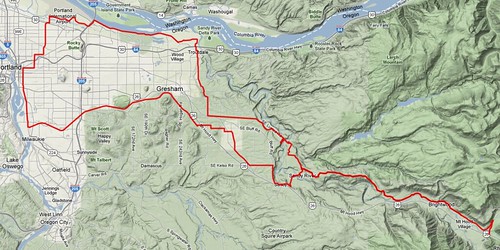
This route takes you all the way from Sellwood up through Sandy (with a stop at Joe’s,) down into the Sandy River gorge for a wander up and down Marmot, followed by a steady climb along the Sandy River up to Lolo Pass Road, where you fishhook back to OR 26, then turn around and retrace your steps down to what used to be Roslyn Lake, where you diverge from the outgoing route to head north (and down) on Ten Eyck & Lusted Roads to Dodge Park, then up out of the Sandy River gorge and roughly northwest to Troutdale, then onwards back into Portland.

About 25 miles of the route is along old Portland Traction ROW; from Sellwood, you take the Springwater Trail out as far as it’s paved (this will probably change soon; the town of Boring is working on their section of the Springwater Trail and may soon pave it all the way down to the edge of Gresham,) and when you’re coming back up out of the gorge, Dodge Park Blvd is the old Mount Hood Railway ROW that was briefly part of Portland Traction before they abandoned the line to Bull Run.

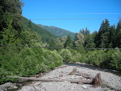
It’s a moderately climby route; in the 100-odd miles of route you end up climbing around 4500 feet (at least according to online mapping software) but the majority of that climbing isn’t all that steep, but is in the “why am I riding so slowly? Am I out of shape?” category. But there are some steep pitches; climbing Marmot from the east isn’t that bad because the steeper part of the road is bypassed by Shipley Road, but when you come back in from the west there are three scarily steep ramps that are only redeemed by being fairly short (and when you go east, you need to be careful of these ramps; the middle ramp has a sharp corner at the bottom of it and if you hit that corner too fast you’ll end up ramming a guardrail and launching yourself into a streambed.)

But if it’s a sunny day, you’ll never forget that you’re heading east towards a stratovolcano; Mount Hood will be visible in many places, getting larger and larger every time you see it until you’re tucked into the upper Sandy River Gorge and the walls of the gorge start to obscure the view (if you’re really fast and want to see more volcano, you can do 20 bonus miles by climbing Lolo Pass Road for some eyepoppingly impressive volcano viewing.)
The only really high traffic part of the loop is along Marine Drive from Troutdale to the vicinity of the airport, and this not only is high traffic but the shoulders tend to pick up pointy tire-eating debris. You can avoid some of the traffic by jumping off onto the Marine Drive bikepath (which is not continuous, but it’s follows about half of the Marine Drive segment) but it works out just as well to have new tires and keep a sharp eye out for broken bottles and other heaps of glass.
A cuesheet is available here, and if you want to ride this for RUSA credit contact me at orc@pell.portland.or.us.