Preriding the Multnomah Falls 100(ish)k
Since I’m volunteering to staff one of the controls on the upcoming Multnomah Falls populaire this means that I don’t get to ride it on the day. But to make up for that I was given the chance to ride it in advance, and that’s what I did on Sunday.
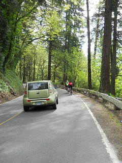
This is not a particularly surprising route for anyone who actually lives in the Portland area; the loop from Portland out the Historic Columbia River Highway to Multnomah Falls is hideously popular with local cyclists, and on any weekend with good weather there are almost as many bicycles as cars winding along the side of the gorge between here and there.
The plan was that the workers would meet at the Jazz Cats coffeehouse in Hollywood at 8:00ish for an 8:30 departure. Well, that was the plan; I got to Jazz Cats at about 8:05 and there was nobody there, so I settled down with some coffee and a muffin to wait. About 10 minutes later, Stasia Honnold showed up – she’d been roped into the preride just the day before – and we sat around and chatted for about 25 minutes before everyone else arrived, and after another 10 minutes of planning we rolled off by a maze of twisty passages northwards to get to Marine Drive, and then east towards the gorge.
There are no surprises on the route inside Portland, aside from the cuesheet going abruptly wrong on milage (when we reached Marine Drive, we were about half a mile up on the cuesheet. Some of that is because the cuesheet was based on a start from Wilshire Park and it needed to be extended down into Hollywood for a Velo Cult start, but some of it was just wrong in the same way the preride for the Bridge of the Gods 200k last year found the milages wrong) and we whisked away to the east at a pretty good pace. In Troutdale, we briefly stopped at Troutdale Community Park to use the facilities and delayer, then hopped across the Sandy River and chugged upgrade towards the info control at Crown Point.
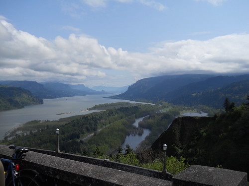
As is traditional, I fell behind on the climb up to Springdale, but as is not traditional, I managed to overhaul them between Springdale and Corbett (after stopping briefly to delayer a little bit more; the day started off cool, but warmed up in a hurry when I needed to hustle upgrade to catch up to everyone) and we rolled up to the Vista House in more-or-less of a group. After a brief pause to use the facilities and pick out an info control question, we plunged back down into the gorge (along the highway; it’s probably faster to go over the cliff, but it would wreck your bicycle and force a DNF) and proceeded past every other waterfall on our way to the turnaround at Multnomah Falls (arriving there approximately 2 miles up on what the cuesheet said. Hmmpf.)
We parked ourselves at Multnomah Falls for a considerable period of time, only prying ourselves away 45 minutes (and one train) later, and then headed back towards Portland. The cuesheet directs you onto I84 to get into Troutdale, but says you can climb up to Crown Point as a slightly longer (3 miles) alternative route. Well, none of us had the slightest interest in riding along I84, so we decided we’d climb back over the hill to get back into civilization.
The climb up to Crown Point is considerably more scenic when you’re not carving around switchbacks at 30 mph, and if you’re like me you’ll get plenty of chances to see the scenery as you creep up the ramp well behind everyone else. But as 700 foot climbs go, it’s really not that bad, and once you’ve climbed around the five switchbacks halfway up the ramp the grades moderate and you can pick up your pace and enjoy the views at a somewhat better speed than you were climbing just a few minutes ago.

Since this is an optional scenic reroute, there’s no need to stop at the Vista House for control purposes, but if it’s not raining it’s always worthwhile to stop for a second or two for the view. And then there’s about a mile of intermittently steep climbing up to the summit at the Women’s Forum (and the road to Larch Mountain, which you DO NOT want to do now unless you brought snowshoes) and then it’s a long pleasant coast all the way back down to the Sandy River(say “hi!” to the Springdale Dragon as you fly past the entrance to the Springdale Job Corps complex just west of downtown Springdale,) then across the river and back into the city of Troutdale.
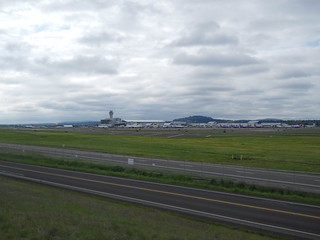
From there you’re back on onto Marine Drive, but on the return you route around the southeast side of the airport. It’s worthwhile to be careful when you go from Marine Drive to the i205 path, because it involves a left turn across Marine Drive and the people driving along there may feel it’s a moral failing to slow down for bicyclists (when I was turning onto the i205 path, I signalled a good long way in advance of any cars, but one of them decided that stopping was wrong and sped up to go around me in the other lane instead of slowing down for a second to wait for me to clear their lane) but after that you’re back on city streets where people are at least used to seeing bicycles on the road.
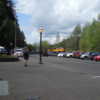
And then south along 34th, wiggling over the Alameda and dodging back into Hollywood, where the ride finishes at Velo Cult. Velo Cult is a pretty nice bike shop, not only because they’ve got a bar and coffee, but because the owner collects interesting old bicycles and thus has a good collection of rando-style shiny! for people to ogle as they sit around and chat.
(Like we did. For two hours before we got hungry and went to Apex to sit around and chat for another two hours. But that’s not relevant here.)
It took us about 5h30 minutes to do the loop (at a brevet average of 12.7mph/moving average of 15.6mph,) but that included about a hour of sitting around at various controls and the 3 mile scenic reroute over Crown Point. With the reroute, it was 72 miles, which is approximately 4 miles over what the cuesheet claims, so the cuesheet will no doubt be revised before the ride. And I took some pictures while I was riding, and a few after the ride was finished (because I dropped the camera on Cornfoot Road and needed to test it out after I wedged it back together when the ride was over :-)
Comments
Comments are closed
Looks like a good route! Look forward to riding it.