flèche flèche glorious flèche!
Last weekend saw the Christian Easter feast, which for a large part of the world includes hunting for easter eggs, eating yourself sick on sweets, and sitting down for a leisurely meal on Sunday. For randonerds in the NW US, it also includes an exercise in insanity called Flèche Northwest, which ends up in Olympia, Washington after starting 24 hours earlier and at least 224 miles away.
I did it last year, so I really wanted to do it again this year, but it was complicated by the 6th being Silas’s birthday . But after much shuffling and rearranging of scheduled events (Silas wanted to do his birthday party the week before his actual birthday, which, thankfully, only conflicted slightly with the ORrando spring 200k, so I was able to get back into town and clean up before the party started) I managed to carve out a block of time starting at ~9pm on Friday and ending at ~noon on Sunday, which was just barely enough time to ride up to Olympia, nap for a few hours, then take the train back down to Portland.
So the ride was on. We didn’t have the entire team from last year – Theo had been recruited by a faster team that wanted to ride 480km or so – but the team still had Bill Alsup, Ed Groth, Asta Chastain, yours truely, and the new team member Ryan Good. Ed had made the route, done the paperwork, named the team (flèche reconstituer), and left only the riding up to the rest of us.
So starting around 8pm on Friday, we started drifting into the Thai restaurant just around the corner from my house (my house wasn’t really usable, because I was down at my parents house celebrating Silas’s birthday), and promptly(ish) at 9pm we headed out towards the Springwater Trail, to ride into downtown, then over skyline via the insanely steep 53rd Drive. It was cool, but not cold (the weather forecast called for mid to high 30s nighttime temps along the route from Portland to Westport (where we were to take the carferry across the river to Cathlamet), and it didn’t take very long before we completely forgot about the temps as we climbed up to Skyline.
I don’t think of myself as a very fast climber (my traditional climbing position is to be faaaar in the back as everyone else evaporates into the distance on any climb longer than about 60 feet) but I seem to be getting faster. I found myself, to what would have been my surprise except I was too busy trying to remember to breathe as I pounded upgrade, climbing as fast as Asta was on this first long ramp.
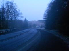
We regrouped on the top (it was considerably colder up here) then dropped down the other side of the hill into the Tualatin River valley, where it was colder yet, and then proceeded eastward towards Timber Road (which would eventually drop us onto highway 47.) But we weren’t moving all that fast, and found ourselves unsuccessfully chasing the closing hours of the grocery stores and minimarts that are scattered along the roads on the north edge of the valley. We reached North Plains just after the grocery store on Commercial St had closed (we stopped in the city water bureau’s pocket-park to snack and layer), we reached Banks after the Thriftway and gas station had closed, and we reached Glenwood after the gas station, store, and bar had closed. (We stopped here anyway because Glenwood was a control, so we needed to take pictures and toss on every layer we had because it had become quite cold indeed.) and then we headed north on Timber Road up past the headwaters of the Nehalem River and into banks of thick freezing fog that would stick with us all the way to Mist, where we would finally climb out of the Nehalem River valley.
There aren’t any services from Glenwood to Vernonia, but there was a minimart there. But it was closed. And after Vernonia, there were no other services until Clatskanie, so we ended up riding 100 miles before our first fud stop.
But to get there was interesting. It was in the mid to high 20s (Fahrenheit) in the Nehalem River valley, and it was foggy, so everything was coated with a thin layer of frost except for our bicycles, which were picking up sheets of ice on every forward facing surface (including us.) By the time we’d reached Vernonia, our water bottles contained icy slush instead of water and/or science diet, and those of us who wear glasses were needing to wipe the glasses like clockwork every minute or so before our vision disappeared into the fog.
And it was cold (did I mention it was cold) enough so that every time we stopped we immediately chilled, so we had to keep moving to stay warm enough (I found that spinning my pedals as fast as I could go was the best way to warm up fast, so I spent a large part of our transit up to Mist pushing a 100+rpm cadence in a very low gear.)
But as we approached Mist, it started to lighten, and the long climb up Clatskanie Mountain was done in the pre-dawn light. Asta and I gapped everyone else by a long stretch on this climb, with me trying (successfully) to keep up with her while she tried (and succeeded) to stay barely ahead of me as we climbed. And then we stopped at the summit of the highway, tried to stay warm (or nap), and waited for everyone else to show up before plunging down the other side of the mountain to the town of Clatskanie, where we hoped to find somewhere that had coffee and maybe breakfast.
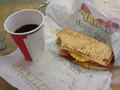
There was coffee (standard american cafe coffee, which is not the sort of coffee that Portlanders usually drink) and fud at the Clatskanie Subway, and it was warm there, so we paused for a considerable amount of time before getting on our bicycles and heading for the ferry terminal in Westport. The ferry runs on 1 hour headways, so we had to wait, but not for very long (20 minutes, I think,) and then we sailed across the mighty Columbia and rode on to the west.
But unfortunately we still weren’t going all that fast, and after a hour or so on Washington Highway 4 we were down to
- a brevet average of 9.1 mph (control closing times are based on 9.5 mph), and
- a little over 3 hours to go 70 kilometers to the next control if we wanted to make it there before it closed.
A brief emergency meeting was needed, so we stopped at the side of the road and discussed what to do; either abandon the flèche or try to go like the dickens to make it to the next control on time.
I didn’t want to abandon, and Ryan, Asta, and Ed were willing to try and go for it. Bill didn’t think he could maintain the needed pace, so he decided to ride the rest of the way in at a more sustainable rate, and that left the four of us to ride west as fast as we could go. Ed lit out for the coast at top speed with the rest of us tagging along in his slipstream, then Asta took a turn pulling us along, and then I stomped on the gas and yanked us along at 27mph for a few miles before I ran out of power and had to follow behind, but, uh oh, we’d lost Ryan already – it turns out that he’d fallen behind when Asta was pulling and was long gone :-( But there were still three of us, and that’s how many people had to do the loop to get credit for it, so we cranked on as fast as we could go trying to get those kilometers out of the way before we ran out of time.
By the time we’d reached highway 101, our water supplies were starting to run down and we had decided that when we passed the next store or gas station we would need to stop and get some water. But, as we eventually realized, even though southern Washington is a bit of a tourist spot and there are lots of vacation spots along the coast, highway 101 is not along the coast and all of those vacation spots are 2-3 miles (or 20-30 minutes) away from the highway. And we didn’t have 20-30 minutes to spare. So we screamed up the coast, water supplies slowly dropping down to 0, until about 10 miles out of Raymond (our next control) my water ran out, and, soon thereafter, so did my energy – I had been snacking pretty much continually as we shot up the coast, but when I didn’t have water to wash down the nasty science diet I just couldn’t eat it. So no water => no food => no power => dropping abruptly from 20mph down to 13 and watching as Asta and Ed disappeared into the distance when we hit the next hill.
And then for the next 8 miles I staggered along, cursing on every pedal stroke, trying to keep up with them. I caught up with them about 3 miles south of Raymond (they’d stopped for the call of the wild and putting air into a tire with a slow leak) then passed them by saying that I would stop at the first store or the Raymond city limits to wait for them.
And, just about 1000 feet this side of the Raymond city limits (and with 17 minutes before the control closed) I saw a grocery store, so pulled off, dashed inside, and returned with water and nasty sports drink just as Ed & Asta saw my bicycle and started pulling into the lot.
We stopped, inhaled a bunch of the water, got some snacks and ate them as if there was no tomorrow, then called this grocery store our Raymond control and signed it off on our brevet cards.
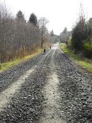
And this left us 6 hours to ride 100km (to get into Olympia) or 72km (to get up to 360km, which is all we needed) which seemed like it would be pretty easy to do. Except that the secondary roads we were planning on using had long gravel sections that climbed abruptly up to the tops of mountains, then plunged equally abruptly down to their feet. Our 22 hour control, which was originally Oakdale, was relocated back to the second mountain summit (I labelled it as “GODFORSAKEN GRAVEL ROAD, WASHINGTON” on my brevet card) and that left us with 32km to ride to get up to the 360km minimum.
This last bit was fun, in a sort of soul-destroying way. First, we wanted to just get off the mountain, so we went sledding down at various speeds (Ed, on his nice rSogn, disappeared into the distance, followed at a distance by Asta, who was followed more closely by yours truely) until we went over a bridge and were magically back onto a gravel surface with 28km to go in 1 hour and 40 minutes. The three of us knew that this was doable, so we put on (what was left of) the afterburners and shot towards Olympia, knocking off 21km in 40 minutes before the clock ticked over to hour 23 and all of our energy reserves went away to die.
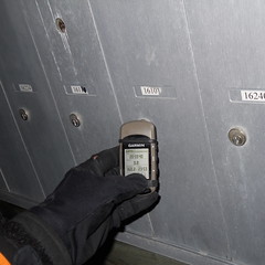
It took us 58 minutes to go 7km. Some of that was because Asta had a flat (her third of the loop) and it took about 15 minutes to change the tire, but mainly because we were all pretty nearly out of puff and could only stagger on at about 10km/h. At 23h56 minutes my GPS ticked over to 360km, so we declared the flèche over and crawled up to the nearest intersection (a short side road with a row of mailboxes) to write down the street address, sign each other’s cards, then take a picture of my GPS showing the distance and the time.
And then we called the organizer, got a route to get into Olympia that was a little more direct (19 miles) than the 22 miles less than our planned route was, and crept towards the end of the line. Ed had burned off all of his energy, so he eventually stopped and called for a cab, and after he’d gotten picked up Asta and I had recovered to the point where we could ride at a more normal pace into Olympia, where we met up with Ed & Theo (Theo’s flèche team had DNFed the previous day, so he just rode up by himself to meet up with us and go to the brunch that SIR was putting on) then eventually Ryan and Bill, and then I got to take a 5 hour nap before waking up, riding out to the Amtrak station, then taking the first Cascades home so I could help with easter egg gathering. (Ed, Asta, Theo, and our friend Kevin (who was on yet another team) did not have to be back in town by noon, so they got to ride back. Color me insanely jealous!)
The gory detail are
- 360.2km in 23h59
- 12,000 feet of climbing according to my (elevation corrected) GPS track
- 79 photos
- 39 hours door to door (and that included a brief stop for coffee before I got home.)
- Almost no services on the route :-(